According to the latest storm information from the Philippine Atmospheric, Geophysical and Astronomical Services Administration (PAGASA), at 5:00 a.m. on November 13 (local time), the center of storm Usagi was 475 km northeast of Virac, Catanduanes or 595 km east of Daet, Camarines Norte.
The storm is moving west at a speed of 25-30 km/h. The strongest wind near the storm's center is maintained at 120 km/h, with gusts of up to 150 km/h.
Typhoon Usagi is expected to move west-northwest to northwest across the Philippine Sea before making landfall along the eastern coast of Cagayan or Isabela on the afternoon of November 14.
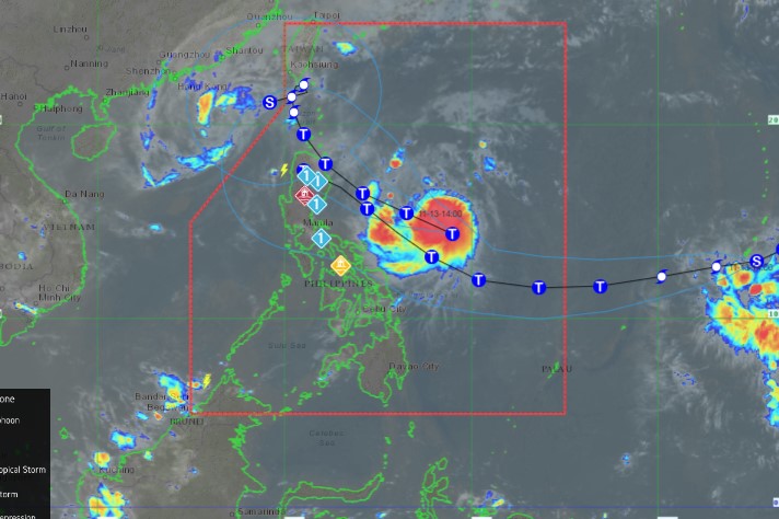
The storm will then emerge over the Luzon Strait on November 15 and turn more north-northwestward and slow down before becoming erratic throughout the weekend. PAGASA stressed that land and coastal water hazards may still exist in areas beyond the predicted landfall point.
Additionally, PAGASA forecasts that Usagi may shift from its forecast track, especially this Wednesday and Thursday (November 12 and 13). There are two other possible scenarios: a track that turns west-northwest and crosses land further south of the current forecast; a track that recurves to the right of the current forecast, mainly away from the northern coast of Luzon.
PAGASA also forecasts that in the next 24 hours, storm Usagi will gradually strengthen and is likely to make landfall in the Philippines when it reaches its maximum intensity.
Meanwhile, newly formed Tropical Storm Man-yi has rapidly intensified into a severe tropical storm, heading towards the Philippines. The storm is expected to continue strengthening to typhoon status before reaching the Philippine Area of Responsibility (PAR) around 2 p.m. on November 15.
With storms continuing to hit, residents and tourists planning to travel to the Philippines should regularly monitor weather forecasts and check for changes in flight schedules to have a safe trip and avoid being affected by storms.

