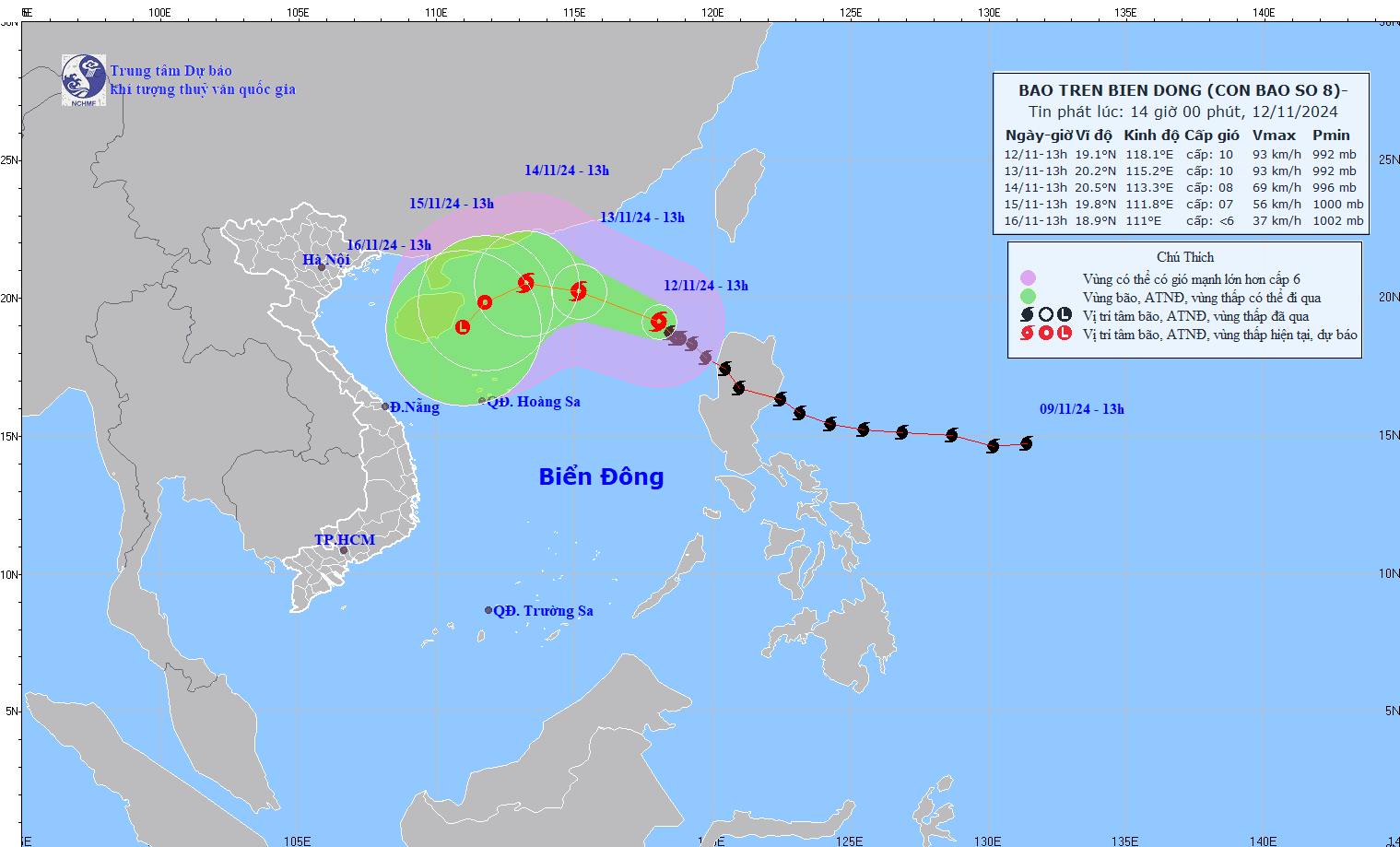
According to the National Center for Hydro-Meteorological Forecasting, at 1:00 p.m. on November 12, the center of storm No. 8 Toraji was located at approximately 19.1 degrees North latitude - 118.1 degrees East longitude, in the eastern sea of the North East Sea. The strongest wind near the center of the storm was level 9-10 (75-102 km/h), gusting to level 12. The storm moved northwest at a speed of 10-15 km/h.
It is forecasted that by 1:00 p.m. on November 13, storm Toraji will move in a West-Northwest direction at a speed of about 15 km/h. The center of the storm will be located at about 20.2N degrees North latitude - 115.2E degrees East longitude, in the northern sea area of the North East Sea.
The strongest wind near the storm center is level 9-10, gusting to level 12. Warning level of risk due to natural disasters: level 3 in the northern sea area of the North East Sea.

At 1:00 p.m. on November 14, the storm continued to move west-northwest at a speed of 10 km/h, gradually weakening in intensity. The center of the storm was located at approximately 20.5 degrees North latitude - 113.3 degrees East longitude, in the northwest sea area of the North East Sea.
The strongest wind near the storm center is level 8, gusting to level 10. Warning level of risk due to natural disasters: level 3 in the northern sea area of the North East Sea.
At 1 p.m. on November 15, Typhoon Toraji changed direction to move west-southwest, continued to slow down to 5-10 km/h and gradually weakened into a tropical depression. The center of the storm was located at about 19.8 degrees North latitude - 111.8 degrees East longitude, in the northwest sea of the North East Sea.
The strongest wind near the storm center is level 6-7, gusting to level 9. Warning level of risk due to natural disasters: level 3 in the northwest sea area of the North East Sea.
Warning from the next 72 to 96 hours, the tropical depression will move in the southwest direction, about 5km per hour, and its intensity will continue to weaken.
Under the influence of storm No. 8, the northern sea area of the North East Sea has strong winds of level 6-7, near the storm's eye level 8-10, gusts of level 12, waves 3.0-5.0m high, near the storm's eye 5.0-7.0m; very rough seas.
With the current weather conditions, people and tourists coming to Hainan Island (China) and the Northern region in the coming days need to pay attention to weather forecasts and check announcements from airlines to be proactive in their schedules.


