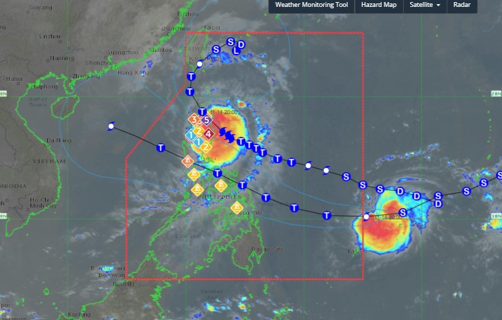
According to the latest storm information from the Philippine Atmospheric, Geophysical and Astronomical Services Administration (PAGASA), at 11:00 a.m. on November 14 (local time), the center of storm Usagi was located at approximately 17.5 degrees North latitude - 122.7 degrees East longitude, in the coastal waters of Divilacan, Isabela or 135 km northeast of Echague, Isabela.
The storm is moving west-northwest at 15 km/h. The strongest wind near the storm's center is maintained at 180 km/h, with gusts of up to 230 km/h.

Typhoon Usagi is expected to move northwest across the Philippine Sea before making landfall along the eastern coast of Cagayan this afternoon, November 14. It will then emerge over the Babuyan Channel on the night of November 14, before making landfall again or passing near the Babuyan Islands.
The forecast track of Usagi is expected to turn north-northwest to northeast-northeast across the sea west of Batanes on November 15, before turning northeast starting on November 16 across the sea east of Taiwan, China, towards the Ryukyu Islands (Japan) in the later stage.
Regardless of where the typhoon makes landfall, PAGASA stressed that land and coastal hazards may still occur in nearby areas. Furthermore, the track may still change from the forecast.
During most of the landfall period, the typhoon is expected to weaken due to increasing interactions with the Luzon and Taiwan (China) mainlands, as well as an increasingly unfavorable environment in the Luzon Strait and the waters east of Taiwan (China). However, the possibility of making landfall as a super typhoon is very high.
Super typhoon Usagi is forecast to weaken into a hurricane from 8:00 p.m. on November 14.
Meanwhile, offshore Typhoon Man-yi will enter the Philippine Area of Responsibility (PAR) as a severe tropical storm. The storm is expected to strengthen into a typhoon by the morning of November 15.
With the current weather conditions, people and tourists who want to travel to Taiwan (China) and the Philippines should pay attention to weather forecasts, check flight schedules to ensure their journeys are not affected and consider postponing or canceling flights if necessary.


