According to the National Center for Hydro-Meteorological Forecasting, due to the influence of storm No. 3, on the evening of September 10-11, the mountainous and midland areas of the North will have moderate rain, heavy rain and thunderstorms, locally very heavy rain with common rainfall of 30-70mm, locally over 120mm; Lao Cai and Yen Bai will have heavy rain, locally very heavy rain with common rainfall of 50-100mm, locally over 200mm.
The Northern Delta, Hoa Binh, and Thanh Hoa regions will have heavy to very heavy rain and thunderstorms with common rainfall of 50-120mm, locally over 250mm.
The area from Nghe An to Thua Thien Hue will have scattered showers and thunderstorms, locally heavy rain with rainfall from 15-30mm, locally over 70mm. In the area from Da Nang to Binh Thuan, the Central Highlands and the South, there will be scattered showers and thunderstorms, locally heavy rain with rainfall from 15-40mm, locally over 80mm. During thunderstorms, there is a possibility of tornadoes, lightning and strong gusts of wind.
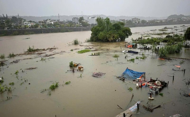
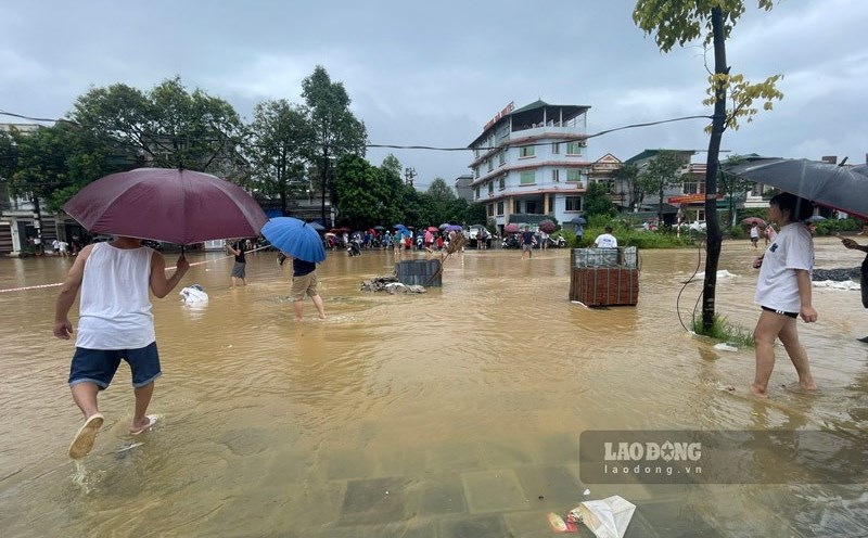
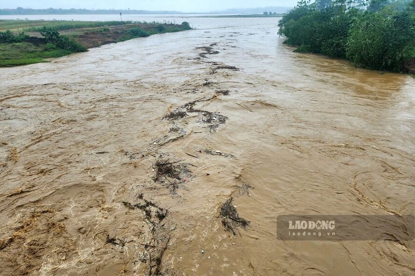
Water levels at downstream stations of the Red River - Thai Binh River system are likely to rise to level 3 and above. Rising flood levels cause flooding in low-lying areas along the river, alluvial areas outside the main dike, causing the riverside dikes to overflow, and landslides to seriously affect key locations in the dike system, embankments, and riverside works in the provinces of Hanoi, Ha Nam, Nam Dinh, Hai Duong, Hung Yen, Thai Binh, and Ninh Binh.
There is a high risk of flooding in low-lying areas along rivers in the provinces of Lang Son, Cao Bang, Lao Cai, Yen Bai, Phu Tho, Bac Giang, Bac Kan, Thai Nguyen, and Hoa Binh; flash floods and landslides on steep slopes in mountainous areas of the North.
Hanoi
Lowest temperature: 23-25 degrees Celsius.
Highest temperature: 27-29 degrees Celsius.
Cloudy with heavy to very heavy rain and thunderstorms in some areas. East to northeast wind level 2-3. Thunderstorms with possibility of tornadoes, lightning and strong gusts of wind.
Northwest
Lowest temperature: 21-24 degrees Celsius, some places below 22 degrees Celsius.
Highest temperature: 26-29 degrees Celsius.
Cloudy, moderate to heavy rain, locally very heavy rain and thunderstorms; Lao Cai, Yen Bai and Hoa Binh areas have heavy to very heavy rain. Light wind. Thunderstorms have the possibility of tornadoes, lightning and strong gusts of wind.
Northeast
Lowest temperature: 22-25 degrees Celsius, mountainous areas below 22 degrees Celsius.
Highest temperature: 26-29 degrees Celsius.
Cloudy, moderate to heavy rain, locally very heavy rain and thunderstorms; especially in the plains there will be heavy to very heavy rain. East to northeast wind level 2-3. During thunderstorms there is a possibility of tornadoes, lightning and strong gusts of wind.
Thanh Hoa - Thua Thien Hue
Lowest temperature: 23-26 degrees Celsius.
Highest temperature: 27-30 degrees Celsius, in the South some places above 30 degrees Celsius.
Cloudy, scattered showers and thunderstorms, locally heavy rain (concentrated in the evening and at night), Thanh Hoa in particular has heavy to very heavy rain and thunderstorms. Light wind. Thunderstorms have the possibility of tornadoes, lightning and strong gusts of wind.
Da Nang to Binh Thuan
Lowest temperature: 26-29 degrees Celsius.
Highest temperature: 32-35 degrees Celsius.
Cloudy, scattered showers and thunderstorms in the late afternoon and evening, locally heavy rain; sunny during the day. Southwest wind level 2-3. Thunderstorms are likely to cause tornadoes, lightning and strong gusts of wind.
Central Highlands
Lowest temperature: 21-24 degrees Celsius.
Highest temperature: 28-31 degrees Celsius, some places above 31 degrees Celsius.
Cloudy, scattered showers and thunderstorms; scattered showers and thunderstorms in the late afternoon and evening, locally heavy rain. Southwest wind level 2-3. Thunderstorms are likely to produce tornadoes, lightning and strong gusts of wind.
Southern Vietnam
Lowest temperature: 24-27 degrees Celsius.
Highest temperature: 31-34 degrees Celsius, some places above 34 degrees Celsius.
Cloudy, scattered showers and thunderstorms; scattered showers and thunderstorms in the late afternoon and evening, locally heavy rain. Southwest wind level 2-3. Thunderstorms are likely to produce tornadoes, lightning and strong gusts of wind.