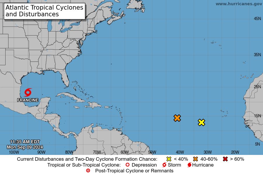
According to the latest information from the US National Hurricane Center (NHC), tropical storm Francine in the Atlantic Ocean has officially formed and is expected to continue to strengthen in the coming days.
As of 3:00 p.m. on September 9, Vietnam time, tropical storm Francine is located near 23.0 degrees North latitude and 94.9 degrees West longitude.
The storm is moving north-northwest at around 7km/h. However, Francine is likely to move more rapidly northeastward from 10.9 and is expected to approach the Louisiana and Upper Texas coasts of the US by 11.9.
The storm's current maximum sustained winds are around 85 km/h, and it is forecasted that the storm may increase in strength from tonight (September 10) and tomorrow (September 11).
Forecasts show Francine could become a major hurricane before making landfall on the northwest Gulf Coast by midweek. Tropical storm-force winds could extend as far as 160 miles from the center.
In response, the NHC issued a hurricane warning for the area from east of High Island, Texas, to the Mississippi-Alabama border, including Vermilion Bay, Lake Maurepas and Lake Pontchartrain. Hurricane and tropical storm warnings were issued for the Louisiana coast and surrounding areas.
The NHC also warned of the risk of severe flooding due to rising water for coastal areas over the next 48 hours.
Francine is forecast to bring 4 to 8 inches of rain, with localized amounts as high as 12 inches. This rainfall has the potential to cause flash flooding and severe urban flooding from the northeastern coast of Mexico to southern Louisiana and southern Mississippi.
The combination of storm surge and tides could cause flooding in coastal areas. Water levels could rise by 0.1-3m depending on the location and timing of the high tide. Large waves generated by this Francie are affecting parts of the Gulf Coast, causing life-threatening rip currents.
In light of the severe weather, if you are planning to travel to areas affected by Hurricane Francine, please stay tuned for updates from your local weather agency and be prepared for severe weather conditions.
Postpone or change travel plans if possible, and if you are in an affected area, follow the instructions of the authorities to stay safe. Be sure to check traffic and weather conditions before travelling and avoid areas at high risk of flooding and storm surge.