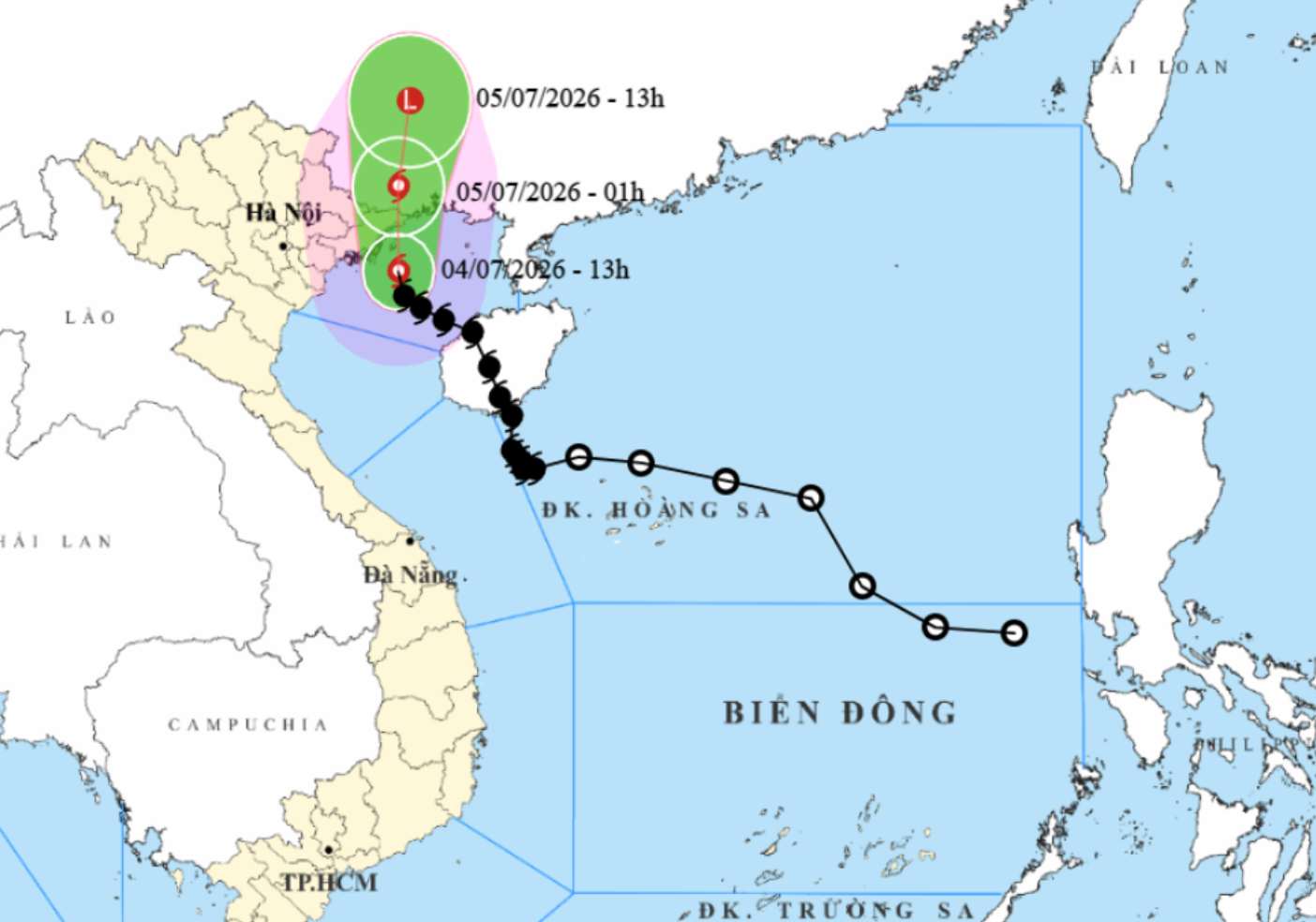
According to the National Center for Hydro-Meteorological Forecasting, as of 2:00 PM on July 4th, the center of storm No. 1 was located at about 20.6 degrees North latitude - 107.9 degrees East longitude, about 90km south of Mong Cai (Quang Ninh).
The strongest wind near the storm center reaches level 9 (75-88km/h), gusting to level 11. In the next 3 hours, the storm will move in a Northwest direction at a speed of about 15km/h.
Quang Ninh synchronously deploys response plans
Forecast as one of the localities directly affected by storm No. 1 and post-storm circulation, from 12:00 PM on July 3rd, Quang Ninh has implemented a sea ban, and at the same time called on all ships and boats operating at sea to enter safe shelters.
The province also reviews aquaculture areas, cages, and points at risk of flooding and landslides; prepares plans to evacuate people and property in key areas. Dyke systems, reservoirs, and key projects are inspected; the coal industry deploys plans to ensure production safety; rescue and relief forces maintain 24/24 hour duty according to the "4 on-site" motto.
According to Quang Ninh Border Guard, functional forces have notified the storm's developments to 6,945 ships with 13,890 crew members and 1,919 cages with 3,838 workers. Border guard stations continue to maintain communication, guide fishing boats to leave dangerous areas, and support people to reinforce vehicles and cages.
In the Co To special zone, the locality has coordinated to organize 18 ship trips to bring 3,147 passengers to the mainland before the sea is rough on July 3. By the evening of the same day, there were still 2,011 passengers on the island, including 16 foreign tourists. The locality has brought 452 ships and 33 rafts to anchor and shelter; reinforced 45 temporary houses and weak houses and prepared about 700 officers and soldiers along with shock forces, vehicles, and rescue equipment to be ready to respond.
Forecast from the afternoon of July 4, the sea area of Co To and Van Don may have strong winds of level 7-8, gusts of level 9-10, waves 2-4m high; the mountainous area of Quang Ninh is at risk of heavy rain, flooding and landslides.
More than 56,000 boats guided to avoid storms
Reporting at the meeting on storm No. 1 response work on the afternoon of July 3, Mr. Pham Duc Luan - Director of the Department of Dyke Management and Natural Disaster Prevention and Control - said that right from the formation of a low pressure area in the East Sea, the National Steering Committee for Civil Defense and ministries and sectors have continuously issued documents directing response.
The National Center for Hydro-Meteorological Forecasting continuously releases forecast and warning bulletins; the Department of Dyke Management and Natural Disaster Prevention and Control organizes 24/24 hour duty and sends text messages via Zalo to about 20.6 million subscribers in areas at risk of being affected.
By the afternoon of July 3, functional forces had notified, counted and guided 56,240 vehicles with more than 249,000 workers to firmly grasp the developments and direction of the storm to proactively move, avoid or escape from dangerous areas. Three localities including Quang Ninh, Ninh Binh and Hung Yen have issued sea ban orders.
The area from Quang Ninh to Thanh Hoa currently has more than 140,000 hectares of coastal aquaculture, about 29,000 cages and rafts and 3,251 watchtowers located in areas at risk of being affected by storms. On the sea dike and river mouth dike system from Quang Ninh to Thanh Hoa, there are still 31 key and critical locations and 5 projects under construction that need to be reinforced.
The Department of Dyke Management and Natural Disaster Prevention and Control emphasized that although storm No. 1 is not too strong, it is the first storm of the season, so absolutely do not be subjective. Localities need to continue to maintain the sea ban order, ensuring safety for ships, aquaculture areas, and tourist areas.
At the same time, review and evacuate people from areas at risk of flooding and landslides, proactively drain water to protect agricultural production, check the safety of reservoirs and dykes, and prepare sufficient forces and vehicles to be ready for rescue and relief when situations occur.
Tourists staying in Quang Ninh during this time should pay close attention to weather developments. Follow local instructions to avoid dangerous storms.


