According to the new low pressure information from the Philippine Atmospheric, Geophysical and Astronomical Services Administration (PAGASA), the low pressure area being monitored is in the Philippine Area of Responsibility.
As of 8:00 p.m. on June 30 (local time), the center of the low pressure was at about 15.2 degrees North latitude - 128.9 degrees East longitude, in the sea about 780km from Aurora.
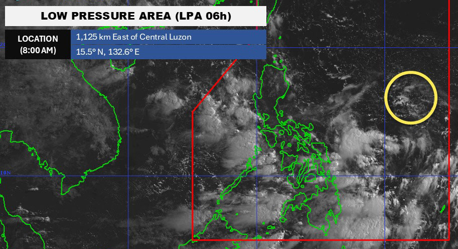
PAGASA forecasts that the low pressure is likely to develop into a tropical depression in the next 24 hours at an average level.
Due to the influence of the low pressure, the Bicol region, Eastern Visayas, Aurora, Quezon, Metro Manila, Mindanao, Mimaropa, the rest of Central Luzon, Calabarzon and Visay, will have cloudy weather with scattered thunderstorms.
Moderate to heavy rain can cause flooding and landslides.
According to the National Center for Hydro-Meteorological Forecasting, on June 30, in the Gulf of Tonkin and the eastern sea area of the Central East Sea, there will be showers and thunderstorms. In the Phu Quy special area, the southwest wind has been recorded at level 5, sometimes level 6.
It is forecasted that during the night of June 30 and July 1, the Gulf of Tonkin, the North and Central East Sea (including Hoang Sa special zone), the East of the South East Sea (including the East sea area of Truong Sa special zone) and the Gulf of Thailand will have scattered thunderstorms. During thunderstorms, tornadoes and strong gusts of wind of level 6-7 may appear, with waves over 2.0m high.
In addition, in the sea area from Lam Dong to Ca Mau, there are strong southwest winds of level 5, sometimes level 6, gusting to level 7. Waves are 1.5 - 2.5m high, rough seas.
Ships operating in the above areas need to pay special attention to the risk of being affected by tornadoes, strong gusts of wind, and large waves.
People and tourists coming to these coastal areas should pay attention to weather forecasts. Follow local instructions to ensure safety throughout the journey.


