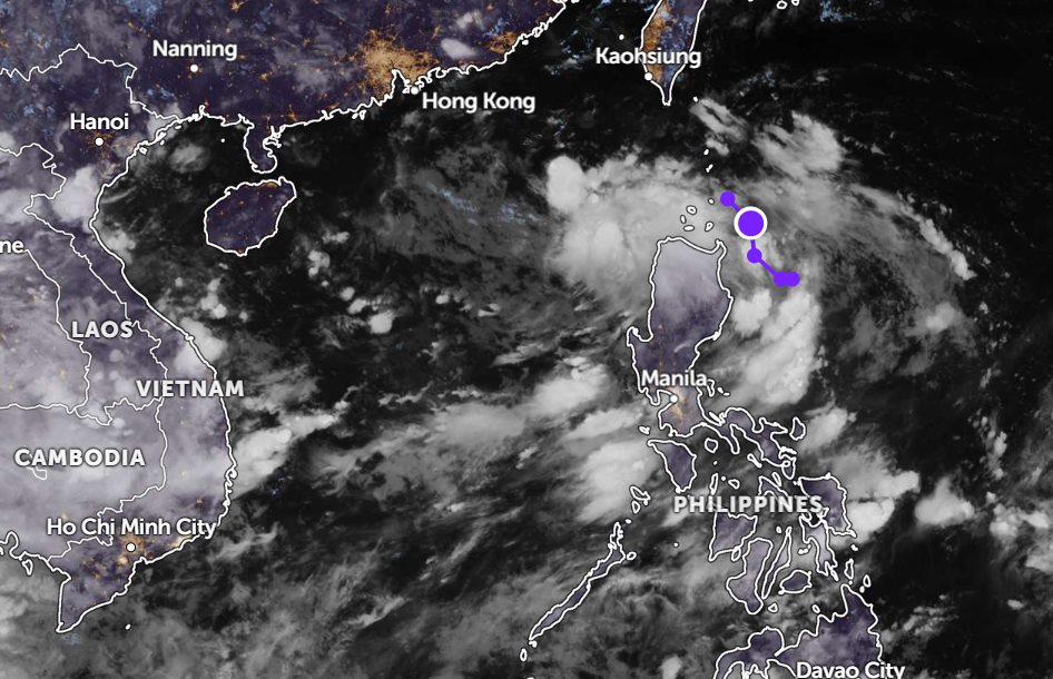
According to new low pressure information from the Philippine Atmospheric, Geophysical and Astronomical Services Administration (PAGASA), the low pressure area being monitored is still outside the mainland of the Philippines.
As of 8:00 a.m. on July 3 (local time), the center of the low pressure was at about 19.5 degrees North latitude - 122.4 degrees East longitude, in the coastal waters of Calayan and Cagayan.
The low pressure tends to move around the Luzon Strait and the possibility of strengthening into a tropical depression in the next 24 hours is at a moderate level.
Meanwhile, the tropical depression being monitored outside the Philippine Area of Responsibility has strengthened into a tropical storm. The storm is named MUN and tends to move further away from the country's Responsibility Area.
Due to the influence of the depression, Ilocos, Cordillera Administrative Region, Cagayan Valley, Aurora, Metro Manila, Pangasinan, Zambales, Bataan, Cavite, Batangas and Mindoro will have cloudy skies with scattered thunderstorms. Tourists traveling to the Philippines should be on guard against heavy rain that can cause floods or landslides.
According to the National Center for Hydro-Meteorological Forecasting, on July 3, showers and thunderstorms are appearing in the Gulf of Tonkin, the sea area from South Quang Tri to Quang Ngai, the North, Central East Sea (including Hoang Sa special zone) and the Gulf of Thailand.
It is forecasted that during the day and night of July 3, scattered showers and thunderstorms will continue to appear in the following seas: Gulf of Tonkin, the North, Central and South East Sea (including the special areas of Hoang Sa and Truong Sa), the sea from South Quang Tri to Quang Ngai, the sea from Lam Dong to Ca Mau, from Ca Mau to An Giang and the Gulf of Thailand.
During thunderstorms, there is a possibility of tornadoes and strong gusts of wind of level 6-7. Waves over 2.0m high
The sea area from Lam Dong to Ca Mau has rough seas and strong gusts of wind. People and tourists to these areas should pay attention to weather forecasts. Follow local instructions to ensure the trip is safe and without incidents.


