According to the storm bulletin, the latest low pressure from the Philippine Atmospheric, Geophysical and Astronomical Services Administration (PAGASA), a new low pressure formed immediately after Typhoon Mekkhala.
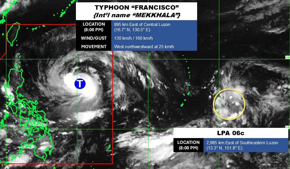
As of 8 pm on June 21, the center of the low pressure was located at about 13.3 degrees North latitude - 151.8 degrees East longitude, about 2,985 km east of the Southeast Luzon region. The strongest wind near the center of the low pressure reached 30-35 km/h.
PAGASA forecasts that the low pressure has the potential to develop into a tropical depression or storm in the next 24 hours.
Because it is still quite far from the mainland, the low pressure only causes thunderstorms at sea, not affecting much the adjacent mainland areas.
In the East Sea, according to the National Center for Hydro-Meteorological Forecasting, on the evening of June 21, monitoring on satellite cloud images, lightning positioning images and weather radar images showed that convective clouds are causing thunderstorms in the sea area of Ha Long Bay and off the coast of Quang Ninh province.
It is forecasted that on the night of June 21, these convective cloud areas will continue to develop and expand, causing showers and thunderstorms for the above sea area.In thunderstorms, there is a possibility of tornadoes, strong gusts of wind and big waves.All ships operating in the above area are at risk of being affected by tornadoes and strong gusts of wind and big waves.
Forecast for the night of June 21 and day of June 22, the area of the Northern Gulf of Tonkin is rainless, visibility over 10km. South wind level 5, sometimes level 6, gusts level 7, waves 1.5 - 2.5m high.
Southern Gulf of Tonkin and the sea area from South Quang Tri to Quang Ngai no rain, visibility over 10km. South to Southwest wind level 4, waves from 0.5 - 2.0m high.
The sea area from Gia Lai to Khanh Hoa, from Lam Dong to Ca Mau has showers and thunderstorms in some places. Visibility over 10km, south to Southwest or Southwest wind level 3-4, waves 0.5 - 2.0m high.
The sea area from Ca Mau to An Giang, the Gulf of Thailand, the South East Sea and the Truong Sa special zone have scattered showers and thunderstorms. In thunderstorms, there is a possibility of tornadoes and strong gusts of wind. Visibility is over 10km, reduced to 4-10km in rain. Sea waves are 0.5 - 2.0m high, possibly higher in thunderstorms.
In the Northern East Sea area and Hoang Sa special zone, there are showers in some places, visibility over 10km. Northwest of the East Sea, south to southwest wind level 3-4, eastern light wind; waves 1.0 - 2.0m high.
The Central East Sea area has scattered showers and thunderstorms in the East. In thunderstorms, there is a possibility of tornadoes, strong gusts of wind. Visibility over 10km, reduced to 4-10km in rain. Light wind, waves 1.0 - 2.0m high, in thunderstorms possibly over 2.0m high.
People and tourists planning to visit these sea areas should follow the weather forecast. Do not go out to sea when the sea is rough and follow local instructions to avoid thunderstorms and big waves at sea that are dangerous.


