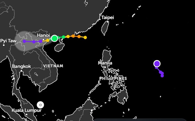
According to the National Center for Hydro-Meteorological Forecasting, as of 9:00 p.m. on July 21, the center of storm No. 3 was at about 20.9 degrees North latitude - 108.3 degrees East longitude, about 70 km East Southeast of Quang Ninh, about 190 km East of Hai Phong, about 210 km East of Hung Yen, about 240 km East Northeast of Ninh Binh.
The strongest wind near the storm center is level 10 (89-102 km/h), gusting to level 13.
It is forecasted that in the next 3 hours, the storm will move in a West-Southwest direction, at a speed of about 10 km/h.
Due to the influence of the storm, from the evening of July 21 to July 23, the Northeast region, the Northern Delta, Thanh Hoa, Nghe An will have heavy to very heavy rain, with a total rainfall of 200-350mm, some places over 600mm.
Other places in the North and Ha Tinh will have moderate rain, heavy rain, locally very heavy (100-200mm, some places >300mm). Warning of heavy rain over 150mm/3 hours.
On the night of July 21 and July 22, the area from Quang Tri to Da Nang, the Central Highlands and the South will have scattered showers and thunderstorms, locally heavy rain (10-30mm, some places >70mm, concentrated rain in the afternoon and evening). Risk of tornadoes, lightning, hail, strong gusts of wind in thunderstorms.
Meanwhile, two low pressure systems are forming near the East Sea.
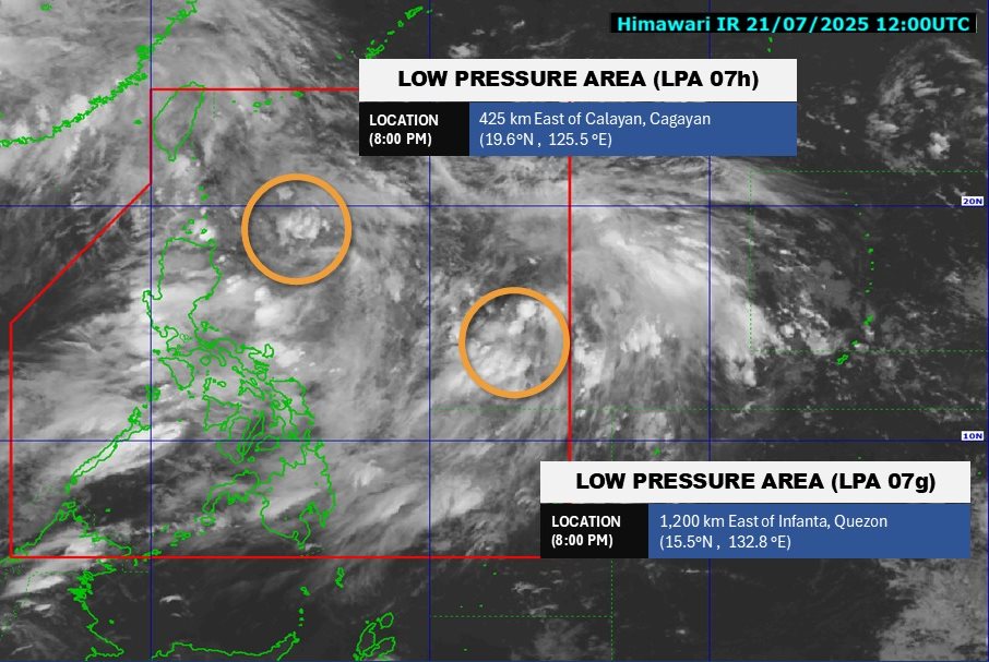
According to the Philippine Atmospheric, Geophysical and Astronomical Services Administration, as of 8:00 p.m. on July 21, the first low pressure (LPA 07) was centered at about 19.6 degrees North latitude - 125.5 degrees East longitude, about 425km east of Calayan, Cangayan. The low pressure is likely to develop into a tropical depression in the next 24 hours.
The second low pressure (LPA 07g) has a center at about 15.5 degrees North latitude - 132.8 degrees East longitude, about 1,200km east of Infanta, Quezon. The low pressure is unlikely to develop into a tropical depression in the next 24 hours.
Under the influence of storm No. 3 Wipha and the low pressure, people and tourists should proactively monitor weather forecasts. Update flight schedules and follow local instructions to ensure safety throughout the journey.