According to the storm news near the East Sea from the National Center for Hydro-Meteorological Forecasting, at 7:00 a.m. on July 18, the center of storm No. 3 Wipha was at about 17.0 degrees North latitude - 124.5 degrees East longitude, in the sea east of Luzon Island (Philippines). The strongest wind near the storm center is level 8 (62-74km/h), gusting to level 10.
Storm No. 3 Wipha is moving northwest at a speed of about 20km/h.
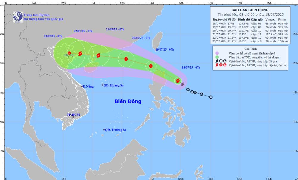
It is forecasted that by 7:00 a.m. on July 19, the storm will continue to move north at a speed of about 20-25 km/h. The storm is likely to enter the East Sea and strengthen.
The center of the storm is located at about 19.5 degrees North latitude - 119.9 degrees East longitude, in the northeastern sea area of the North East Sea. The strongest wind near the storm center is level 8-9, gusting to level 11. Natural disaster risk level: level 3 for the northeastern sea area of the North East Sea.
At 7:00 a.m. on July 20, the storm will continue to move in the West Northwest direction at a speed of about 20km/h, likely to strengthen. The center of the storm is located at about 20.7 degrees North latitude - 115.7 degrees East longitude, about 590 km east of the Lusi Peninsula (China).
The strongest wind in the storm center is level 10, gusting to level 12. Natural disaster risk level: level 3 for the northern sea area of the North East Sea.
It is forecasted that by 7:00 a.m. on July 21, the storm will continue to move in the West Northwest direction at a speed of about 20km/h and will continue to strengthen. The center of the storm is located at about 21.3 degrees North latitude - 111.0 degrees East longitude, in the sea east of the Lusi Peninsula (China).
The strongest wind near the storm center is level 11, gusting to level 15. Natural disaster risk level: level 3 for the northern sea area of the North East Sea.
It is forecasted that in the next 72 to 120 hours, the storm will move mainly in the West direction, traveling 15-20km per hour and gradually weakening.
Due to the influence of storm Wipha, the sea area east of the North East Sea from the afternoon of July 18 will have strong winds of level 6-7, the area near the storm's eye will have strong winds of level 8-9, gusts of level11, waves 3.0-5.0m high. The sea is very rough.
Ship operating in the above-mentioned dangerous areas are likely to be affected by thunderstorms, whirlwinds, strong winds, and large waves.
People and tourists planning to travel to coastal areas where the storm passed should pay attention to weather forecasts. Check flight schedules and follow local instructions to ensure safety.


