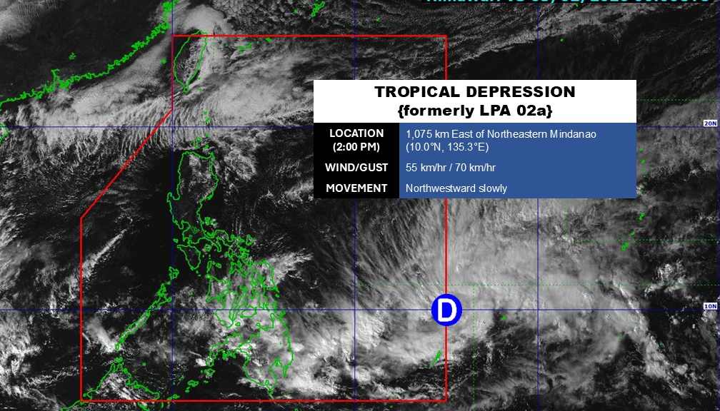
According to the latest weather forecast from the Philippine Atmospheric, Geophysical and Astronomical Services Administration (PAGASA), the low pressure near the East Sea has officially strengthened into a tropical depression.
As of 2:00 PM today (local time), the center of the tropical depression is located at about 10.0 degrees North latitude - 130.3 degrees East longitude, about 1,075 km east of the Northeast Mindanao area.
The strongest wind near the center of the tropical depression reached 55 km/h, gusting up to 70 km/h. The tropical depression is moving slowly in a Northwest direction, towards the mainland Philippines.
Due to the influence of the tropical depression, the eastern Visayas, central Visayas, Negros archipelago, Caraga, Davao region, Batanes archipelago, Babuyan, North Mindanao and Zamboanga peninsula have gloomy skies, with scattered thunderstorms. Heavy rain may cause floods and landslides at an average level.
In the East Sea, according to the National Center for Hydro-Meteorological Forecasting, on the day and night of February 3, many sea areas across the country continued to be affected by strong Northeast winds, causing strong rough seas and high waves.
Accordingly, in the Northern East Sea area (including the Hoang Sa special zone sea area), Northeast wind is strong at level 6, especially the Northeast at times level 7, gusting at level 8-9. Strong sea waves, waves from 3.0 to 5.0 meters high.
In the sea area from Khanh Hoa to Ca Mau and the western sea area of the South East Sea (including the western sea area of Truong Sa special zone), Northeast wind strong at level 6, during the day sometimes level 7, gusts level 8-9. Strong sea waves, waves 2.0 to 5.0 meters high.
In the central area of the East Sea, Northeast wind is strong at level 5, sometimes level 6, gusting at level 7-8. Sea is rough, waves are 2.0 to 4.0 meters high.
On February 4th, the northeastern sea area of the Northern East Sea continued to have strong Northeast winds at level 6, gusts at level 7-8; rough seas, waves 2.0 to 4.0 meters high.
The sea area from Khanh Hoa to Ca Mau has strong Northeast winds at level 5, sometimes level 6, gusts at level 7-8; rough seas, waves from 2.0 to 4.0 meters high. On the night of February 4th, the wind in the sea areas tends to gradually decrease.
All ships operating in the above-mentioned areas are at high risk of being affected by strong winds and large waves.
People and tourists coming to these sea areas should pay attention to weather forecasts. Follow local instructions to avoid strong winds and big waves at sea causing danger.


