According to the latest weather forecast from the Philippine Atmospheric, Geophysical and Astronomical Services Administration (PAGASA), a low tide is strengthening outside the Philippine area of responsibility.
As of 2 am this morning (local time), the center of the low pressure was located at about 9.8 degrees North latitude - 138.0 degrees East longitude, about 1,370 km east of the Northeast Mindanao area.
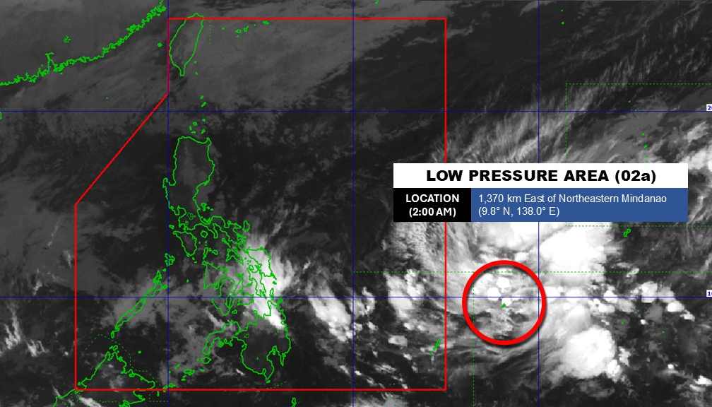
The low pressure area is highly likely to develop into a tropical depression in the next 24 hours.
Because it is still quite far away, the low pressure has not affected the mainland Philippines.
In the East Sea, according to the National Center for Hydro-Meteorological Forecasting, on February 3rd, the North East Sea area (including the Hoang Sa special zone) has strong Northeast winds of level 6, especially the Northeast at times level 7, gusts of level 8-9; strong sea waves. Sea waves are 3.0 to 5.0m high.
The sea area from Khanh Hoa to Ca Mau and the sea area west of the South East Sea (including the sea area west of the Truong Sa special zone) have strong Northeast winds at level 6, at times level 7 during the day, gusts at level 8-9; strong rough seas. Sea waves are 2.0 to 4.0m high.
The area between the East Sea and the sea area from Gia Lai to Dak Lak has strong Northeast winds at level 5, sometimes level 6, gusts at level 7-8; rough seas. Sea waves are 2.0 to 4.0m high.
On February 4th, day and night, the northeastern sea area of the Northern East Sea has strong Northeast wind at level 6, gusting at level 7-8; strong sea waves, sea waves from 3.0 to 5.0m high.
The sea area from Khanh Hoa to Ca Mau has strong Northeast winds at level 5, sometimes level 6, gusts at level 7-8; rough seas, sea waves from 2.0 to 4.0m high. Night winds in the sea areas gradually decrease. Level of disaster risk at sea: level 2.
All ships operating in the above areas are at high risk of being affected by strong winds and large waves.
People and tourists coming to these sea areas should pay attention to weather forecasts. Follow local instructions to avoid strong winds and big waves at sea causing danger.


