According to the latest weather forecast from the Philippine Atmospheric, Geophysical and Astronomical Services Administration (PAGASA), the low pressure near the East Sea has officially strengthened into a tropical depression.
As of 8 am this morning (local time), the center of the tropical depression is located at about 11.3 degrees North latitude - 137.7 degrees East longitude, about 1,305 km east of the eastern Visayas.
The strongest wind near the center of the tropical depression reached 45 km/h, gusting up to 55 km/h. The tropical depression is moving in the North - Northeast direction at a speed of about 10 km/h.
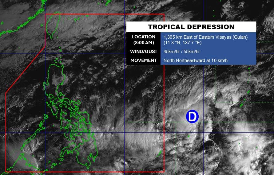
Due to being quite far from the mainland, the tropical depression has not significantly affected the mainland area of the Philippines.
In the East Sea, according to the National Center for Hydro-Meteorological Forecasting, this morning March 10, the North East Sea area had strong Northeast winds at level 6, especially the northeast sea area at level 7. At Bach Long Vy station, strong Northeast winds at level 6 were recorded, sometimes level 7, gusting at level 8.
Forecast for the day and night of March 10, the North East Sea area (including Hoang Sa special zone) has level 6 Northeast wind, especially the northeast sea area sometimes level 7, gusts level 8 - 9; strong rough seas. Sea waves are 3.0 - 5.0m high, Northeast direction.
The Central East Sea area has strong Northeast winds of level 5, sometimes level 6; especially the northern sea area during the day has strong winds of level 6, gusts of level 7 - 8; rough seas. Sea waves are 3.0 - 5.0m high, northeast direction.
In the sea area from Khanh Hoa to Vinh Long and the west of the South East Sea area (including the west of Truong Sa special zone), Northeast wind is strong at level 6, sometimes level 7, gusting at level 8 - 9; strong sea waves. Sea waves are 2.0 - 4.0m high, Northeast direction.
The Gulf of Tonkin has level 6 Northeast wind, sometimes level 7 in the morning, gusts of level 8 - 9; strong rough seas, gradually reduced wind at night. Sea waves are 2.0 - 3.5m high, Northeast direction.
The area from South Quang Tri to Dak Lak has Northeast wind level 5, sometimes level 6, gusts level 7 - 8; rough seas, night wind gradually decreases. Sea waves are 3.0 - 5.0m high, northeast direction.
During the day and night of March 10, the sea area from South Quang Tri to Khanh Hoa will have scattered showers and thunderstorms.
On the day and night of March 11, the sea area from Khanh Hoa to Vinh Long and the western part of the South East Sea (including the western part of the Truong Sa special zone) will continue to have strong Northeast winds of level 6, gusts of level 7 - 8; rough seas; waves 2.0 - 4.0m high.
The northeastern sea area of the Northern East Sea has strong Northeast winds of level 5, sometimes level 6, gusts of level 7 - 8; rough seas; waves 2.0 - 4.0m high.
People and tourists planning to visit these areas should pay attention to weather forecasts. Avoid going out to sea when the sea is rough and follow local instructions to avoid storms and big waves at sea that are dangerous.


