According to storm news, the latest low pressure from the Joint Typhoon Warning Center (JTWC), two low pressures are moving towards the East Sea.
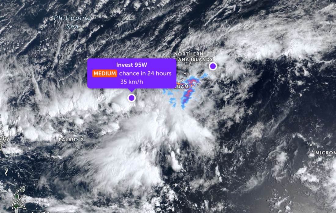
The low pressure bearing the symbol Invest 95W is located at 10.4 degrees North latitude - 138.5 degrees East longitude, about 1,425 km northeast of Mindanao.
The strongest wind near the center of the low pressure reached 35 km/h. The low pressure is forecast to develop moderately into a tropical depression in the next 24 hours.
Meanwhile, another low pressure with the symbol Invest 96W is located near the Northern Mariana Islands area. The strongest wind near the center of the low pressure reaches 35 km/h. The low pressure is unlikely to strengthen into a tropical depression in the next 24 hours.
Because it is still quite far from the mainland, the low pressure has not caused much impact on the adjacent mainland areas.
Meanwhile, in the East Sea, according to the National Center for Hydro-Meteorological Forecasting, on the morning of March 9, the North East Sea area had strong Northeast winds at level 6, especially the northeast sea area at level 7.
The Northern East Sea area (including the Hoang Sa special zone) has strong Northeast wind at level 6; especially the northeast sea area at level 7, gusts at level 8-9. Strong sea waves. Sea waves 3.0-5.0m high.
The Gulf of Tonkin area has strong Northeast winds at level 5, then increasing to level 6, gusting to level 7-8. Sea is rough. Sea waves are 2.0-3.0m high.
The sea area from Khanh Hoa to Vinh Long and the west of the South East Sea area (including the western Truong Sa special zone) has strong Northeast winds at level 5, sometimes level 6, gusts at level 7; from night the wind gradually strengthens to level 6, gusts at level 7-8. Sea rough. Sea waves 2.0-3.0m high.
The area from South Quang Tri to Dak Lak (from the night of March 9) has gradually strengthened Northeast winds of level 5, sometimes level 6, gusts of level 7-8. Sea is rough. Sea waves are 2.0-4.0m high.
In the North of the Central East Sea area (from the night of March 9), the Northeast wind will gradually strengthen to level 6, gusting to level 7-8. Seas are rough. Sea waves are 2.0-4.0m high.
On March 9, day and night, the sea area from Da Nang City to Khanh Hoa will have scattered showers and thunderstorms; in thunderstorms, there is a possibility of tornadoes and strong gusts of wind.
On March 10, day and night, the North East Sea area (including Hoang Sa special zone) has strong Northeast winds at level 6, sometimes level 7, gusts at level 8-9, strong rough seas; sea waves 3.0-5.0m high.
The sea area north of the Central East Sea area has strong Northeast winds at level 6, gusts at level 7-8, rough seas; sea waves 3.0-5.0m high.
The Gulf of Tonkin and the sea area from South Quang Tri to Gia Lai have level 5 Northeast wind, sometimes level 6, gusts level 7-8, rough seas; waves 2.0-5.0m high.
The sea area from Dak Lak to Vinh Long and the western part of the South East Sea (including the western part of the Truong Sa special zone) has strong Northeast winds at level 6, sometimes level 7, gusts at level 8-9, strong rough seas; waves 2.0-4.0m high.
People and tourists planning to visit these areas should pay attention to weather forecasts. Avoid going out to sea when the sea is rough and follow local instructions to avoid storms and big waves at sea that are dangerous.


