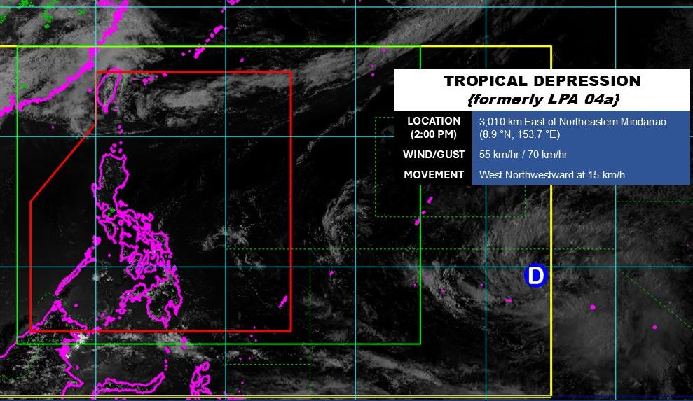
According to storm news, the latest low pressure from the Philippine Atmospheric, Geophysical and Astronomical Services Administration (PAGASA), the low pressure near the East Sea has officially strengthened into a tropical depression.
As of 2 pm today April 8 (local time), the center of the low pressure was located at about 8.9 degrees North latitude - 153.7 degrees East longitude, about 3,010 km east of the Northeast of Mindanao.
The strongest wind near the center of the low pressure reached 55 km/h, gusting up to 70 km/h. The tropical depression is moving in the West - Northwest direction at a speed of about 15 km/h.
Due to being far from the mainland, the tropical depression has not significantly affected the weather on the islands of the Philippines.
In the East Sea, according to the National Center for Hydro-Meteorological Forecasting, the Gulf of Tonkin area has showers and thunderstorms in some places, visibility over 10km. South to Southeast wind level 4-5, especially in the North of the Gulf of Tonkin in the evening and night, sometimes strong level 6, gusts level 7-8, rough seas; waves commonly from 1.0-2.5m high.
From Quang Tri to Khanh Hoa no rain, visibility over 10km. Wind mainly south to southwest level 3-5; waves 1.0-2.0m high.
The area from Lam Dong to An Giang and the Gulf of Thailand has stable weather, no rain, visibility over 10km. Light wind, low waves from 0.5-1.5m.
The northern part of the East Sea has showers and thunderstorms in some places, south wind level 4-5, waves 2.0-3.0m high. The remaining areas (center and south of the East Sea, including the Hoang Sa and Truong Sa areas) have little rain, good visibility over 10km, general wind weak to level 4, waves 0.5-2.5m high.
People and tourists planning to visit these sea areas should pay attention to weather forecasts. Follow local instructions and avoid going to sea when the sea is rough to ensure safety.


