According to storm news, the latest low pressure from the Philippine Atmospheric, Geophysical and Astronomical Services Administration (PAGASA), on the evening of May 5, a low pressure near the East Sea officially strengthened into a tropical depression.
As of 8 pm on May 5 (local time), the center of the tropical depression with symbol 05b is located at 8.4 degrees North latitude - 148.8 degrees East longitude, about 2,475 km east of the Northeast Mindanao region.
The strongest wind near the center of the low pressure reached 55 km/h, gusting up to 70 km/h. The low pressure is moving in a West direction at a speed of about 15 km/h, towards the mainland Philippines.
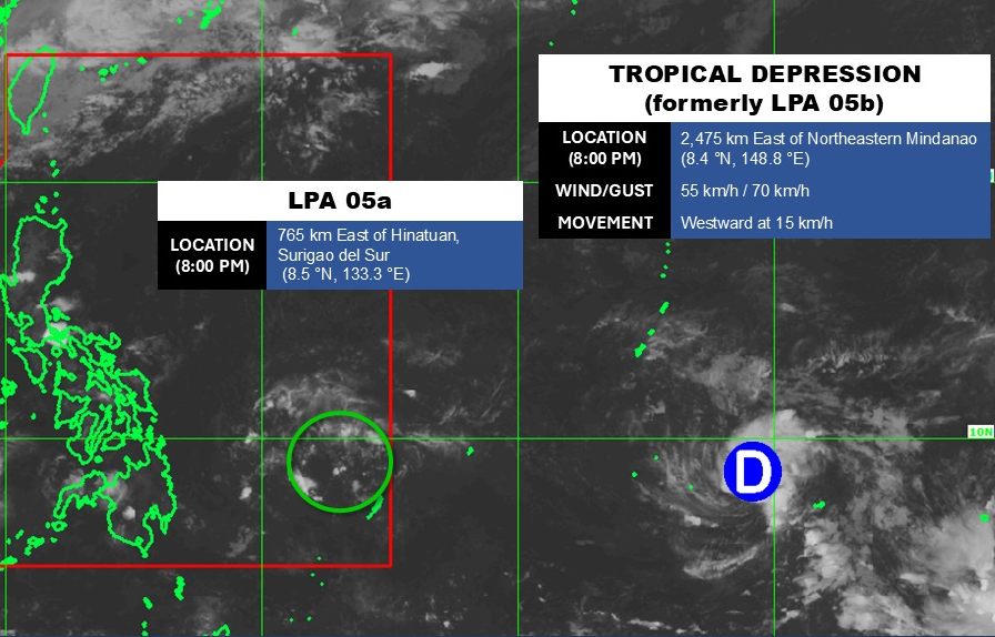
Meanwhile, the low pressure area coded 05a is still operating in the Pacific Ocean. The center position is at about 8.5 degrees North latitude - 133.3 degrees East longitude, which has entered the Philippine responsibility area.
The strongest wind near the low pressure center reaches 30 km/h. The low pressure is unlikely to develop strongly into a storm in the next 24 hours.
However, the low pressure has caused moderate to heavy rain in the central Philippines, as it moves deeper into the area of responsibility of this country.
In the East Sea, according to the National Center for Hydro-Meteorological Forecasting, on May 5, the northeastern area of the Northern East Sea has strong winds of level 6, gusts of level 7-8. Sea rough.
The sea area from South Quang Tri to Da Nang City, Ca Mau to An Giang, the Gulf of Thailand and the Central and Southern East Sea areas (including Truong Sa special zone) have scattered showers and thunderstorms.
In thunderstorms, there is a possibility of tornadoes and strong gusts of wind. From the night of May 5, the wind in the northeastern sea area of the Northern East Sea continues to weaken gradually. Level of disaster risk at sea: level 2.
People and tourists who plan to go to these sea areas or places where low pressure passes should pay attention to weather forecasts. Avoid going out to sea when the sea is rough and follow local instructions to avoid storms and big waves at sea that are dangerous.


