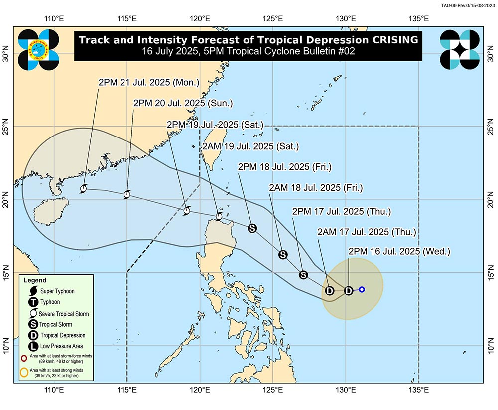
According to the tropical depression news from the National Center for Hydro-Meteorological Forecasting, at 4:00 p.m. on July 16, the center of the tropical depression was at about 14.2 degrees North latitude - 130.1 degrees East longitude, in the sea east of the Philippines. The strongest wind near the center is level 6-7 (39-61km/h), gusting to level 9. The tropical depression is moving in a West-Northwest direction at a speed of about 15km/h.
It is forecasted that in the next 24-48 hours, the tropical depression will continue to move in the West Northwest direction at a speed of 15-20km/h. At 4:00 p.m. on July 17, the center of the tropical depression was at about 15.0 degrees North latitude - 126.5 degrees East longitude, in the sea east of the North of the Philippines and was likely to strengthen into a storm with an intensity of level 8, gusting to level 10.
At 4:00 p.m. on July 18, the storm continued to move northwest at a speed of about 20km/h. The center of the storm is located at about 17.2 degrees North latitude - 123.0 degrees East longitude, in the sea east of Luzon Island (Philippines). The storm intensity is forecast to strengthen to level 10, gusting to level 12.
Warning in the next 48-72 hours, the storm will continue to move mainly in the West Northwest direction, traveling 20-25km per hour and is likely to strengthen as it approaches the East Sea.
On land, the North will have showers and thunderstorms in some places in the evening and at night; hot during the day.
In the mountainous areas on the night of July 16, there will be scattered showers and thunderstorms, with some places having heavy rain.
The area from Thanh Hoa to Da Nang and the East of the provinces from Quang Ngai to Dak Lak will have showers and thunderstorms in some places in the evening and at night; hot sunny day, some places are very hot.
Other areas will have showers and thunderstorms in some places in the late afternoon and night; the Central and Southern Plateau will have scattered showers and thunderstorms in the late afternoon and evening, with some places having heavy to very heavy rain.
People and tourists need to be on guard during thunderstorms with the possibility of tornadoes, lightning, hail and strong gusts of wind.
Weather forecast for tonight and tomorrow, July 17:
Hanoi City Lowest temperature: 27-29 degrees Celsius Highest temperature: 34-36 degrees Celsius, some places above 36 degrees Celsius Cloudy, showers and thunderstorms in the evening and at night; hot sunny during the day.
Light wind.During thunderstorms, there is a possibility of tornadoes, lightning, hail and strong gusts of wind.
Northwest Lowest temperature: 24-27 degrees Celsius, some places below 23 degrees Celsius Highest temperature: 33-36 degrees Celsius, some places above 36 degrees Celsius Cloudy, scattered showers and thunderstorms at night, locally heavy rain; hot sunny day.
Light wind.During thunderstorms, there is a possibility of tornadoes, lightning, hail and strong gusts of wind.
Northeast Lowest temperature: 26-29 degrees Celsius Highest temperature: 33-36 degrees Celsius, some places above 36 degrees Celsius Cloudy, showers and thunderstorms in the evening and at night; scattered showers and thunderstorms in mountainous areas, locally heavy rain; hot sunny day.
Light wind.During thunderstorms, there is a possibility of tornadoes, lightning, hail and strong gusts of wind.
Thanh Hoa to Hue Lowest temperature: 26-29 degrees Celsius Highest temperature: 34-37 degrees Celsius, some places above 37 degrees Celsius Cloudy, showers and thunderstorms in the evening and at night; hot sunny day, some places with severe heat.
Southwest wind level 2-3.During thunderstorms, there is a possibility of tornadoes, lightning and strong gusts of wind.
South Central Coast Lowest temperature: 25-28 degrees Celsius Highest temperature: 34-37 degrees Celsius, some places above 37 degrees Celsius Cloudy, showers and thunderstorms in the evening and at night; hot sunny day, some places with severe heat.
Southwest wind level 2-3.During thunderstorms, there is a possibility of tornadoes, lightning and strong gusts of wind.
Central Highlands Lowest temperature: 21-24 degrees Celsius Highest temperature: 28-31 degrees Celsius, some places above 32 degrees Celsius Cloudy, scattered showers and thunderstorms in some places; in the afternoon and evening, there will be scattered showers and thunderstorms, locally heavy rain in some places.
Southwest wind level 2-3.During thunderstorms, there is a possibility of tornadoes, lightning and strong gusts of wind.
Southern region Lowest temperature: 23-26 degrees Celsius Highest temperature: 29-32 degrees Celsius, some places above 32 degrees Celsius Cloudy, scattered showers and thunderstorms, locally heavy to very heavy rain.
Southwest wind level 2-3.During thunderstorms, there is a possibility of tornadoes, lightning and strong gusts of wind.
Ho Chi Minh City Lowest temperature: 24-26 degrees Celsius Highest temperature: 30-32 degrees Celsius Cloudy, scattered showers and thunderstorms, locally heavy to very heavy rain.Southwest wind level 2-3.
During thunderstorms, there is a possibility of tornadoes, lightning and strong gusts of wind.