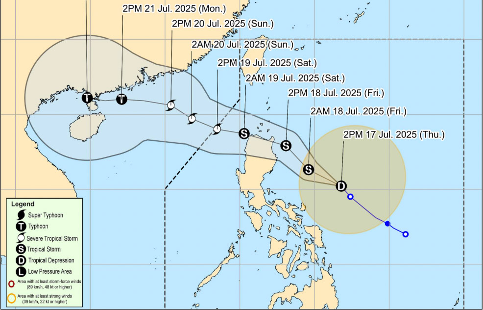
According to the tropical depression near the East Sea from the National Center for Hydro-Meteorological Forecasting, at 1:00 p.m. on July 17, a tropical depression was identified as active in the sea east of the Philippines, with its center at about 15.1 degrees North latitude 0126.9 degrees East longitude. The strongest wind near the center of the tropical depression will reach level 7 (50-61km/h), gusting to level 9.
The tropical depression is moving in a West-Northwest direction at a speed of 15-20km/h.
It is forecasted that in the next 24 to 48 hours, the tropical depression will continue to move in the West Northwest direction. At 1:00 p.m. on July 18, the center of the low pressure is expected to be in the sea east of Luzon Island (Philippines), at about 17.4 degrees North latitude - 123.5 degrees East longitude. The wind intensity will increase to level 8-9, gusting to level 11 and is likely to strengthen into a storm.
At 1:00 p.m. on July 19, the center of the storm will be in the eastern sea of the North East Sea, at about 18.8 degrees North latitude - 119.1 degrees East longitude. The intensity continued to increase, reaching level 10, gusting to level 12.
The dangerous area at sea with strong winds of level 6 or higher is determined from latitude 16.5 to 21.0 degrees North and longitude 117.5 to 120.0 degrees East. The natural disaster risk level in the northeastern sea of the East Sea is warned at level 3.
In the next 48 to 72 hours, the storm is forecast to continue moving in the West Northwest direction at a speed of 20-25km/h and is likely to continue to strengthen.
People, fishermen and tourists need to proactively monitor information and have timely response plans.
It is forecasted that on the night of July 17 and 18, in the East of the North East Sea, the Central and South East Sea (including the Truong Sa archipelago), the sea area from Lam Dong to Ca Mau, from Ca Mau to An Giang and the Gulf of Thailand, there will be scattered showers and thunderstorms. During thunderstorms, there is a possibility of tornadoes, strong gusts of wind of level 6-8, waves over 2.0m high.
Strong winds and rough seas were recorded in the sea area from Lam Dong to Ho Chi Minh City and the Central and South East Sea areas with southwest winds of level 5, sometimes level 6, gusting to level 7-8. Tomorrow the wind will tend to increase, the waves will be 2.5-3.5m high, the sea will be rough.
In the East of the North East Sea, strong winds of level 5, until tomorrow afternoon will increase to level 6-7, gusting to level 9; waves 2.5-3.5m high, rough seas.

On land, the weather in the North from the night of July 17 to the night of July 18 will have showers and thunderstorms in some places in the evening and at night, hot days, and some places will have severe heat.
From Thanh Hoa to Da Nang, the East of the provinces from Quang Ngai to Dak Lak and Khanh Hoa: showers and thunderstorms in some places in the evening and at night; hot sunny day, some places are very hot.
Other areas will have showers and thunderstorms in some places in the late afternoon and night; the Central and Southern Plateau will have scattered showers and thunderstorms in the late afternoon and evening, with some places having heavy rain.
People and tourists should be on guard against the risk of flash floods, landslides, and land subsidence on steep slopes and small streams in Quang Ngai and Lam Dong.
Weather forecast for the night of July 17 and July 18:
Hanoi Lowest temperature: 27-29 degrees Celsius Highest temperature: 35-37 degrees Celsius, some places above 37 degrees Celsius Cloudy, showers and thunderstorms in the evening and at night, hot and hot days and severe heat.
Light wind.During thunderstorms, there is a possibility of tornadoes, lightning, hail and strong gusts of wind.
Northwest Lowest temperature: 24-27 degrees Celsius, some places below 23 degrees Celsius Highest temperature: 34-37 degrees Celsius, some places above 37 degrees Celsius Cloudy, showers and thunderstorms in the evening and at night, hot sunny during the day, some places are very hot.
Light wind.During thunderstorms, there is a possibility of tornadoes, lightning, hail and strong gusts of wind.
Northeast Lowest temperature: 26-29 degrees Celsius Highest temperature: 34-37 degrees Celsius, some places above 37 degrees Celsius Cloudy, showers and thunderstorms in the evening and at night, hot sunny during the day, some places are very hot.
Light wind.During thunderstorms, there is a possibility of tornadoes, lightning, hail and strong gusts of wind.
Thanh Hoa to Hue Lowest temperature: 26-29 degrees Celsius Highest temperature: 34-37 degrees Celsius, some places above 37 degrees Celsius Cloudy, showers and thunderstorms in the evening and at night; hot sunny day, some places with severe heat.
Southwest wind level 2-3.During thunderstorms, there is a possibility of tornadoes, lightning and strong gusts of wind.
South Central Coast Lowest temperature: 25-28 degrees Celsius Highest temperature: 34-37 degrees Celsius, some places above 37 degrees Celsius Cloudy, showers and thunderstorms in the evening and at night; hot sunny day, some places with severe heat.
Southwest wind level 2-3.During thunderstorms, there is a possibility of tornadoes, lightning and strong gusts of wind.
Central Highlands Lowest temperature: 19-22 degrees Celsius Highest temperature: 28-31 degrees Celsius, some places above 31 degrees Celsius Cloudy, scattered showers and thunderstorms in some places, scattered showers and thunderstorms in the afternoon and evening, locally heavy rain in some places.
Southwest wind level 2-3.During thunderstorms, there is a possibility of tornadoes, lightning and strong gusts of wind.
Southern region Lowest temperature: 24-27 degrees Celsius Highest temperature: 30-33 degrees Celsius, some places above 33 degrees Celsius Cloudy, scattered showers and thunderstorms in some places, in the afternoon and evening there are scattered showers and thunderstorms, locally heavy rain in some places.
Southwest wind level 2-3.During thunderstorms, there is a possibility of tornadoes, lightning and strong gusts of wind.
Ho Chi Minh City Lowest temperature: 24-26 degrees Celsius Highest temperature: 30-32 degrees Celsius Cloudy, scattered showers and thunderstorms in some places, in the afternoon and evening there are scattered showers and thunderstorms, locally heavy rain in some places.Southwest wind level 2-3.
During thunderstorms, there is a possibility of tornadoes, lightning and strong gusts of wind.


