Tropical depression is about to strengthen into a storm approaching the East Sea

Chí Long |

The tropical depression near the East Sea is forecast to strengthen into a storm in the next 24 hours.

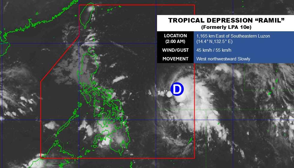
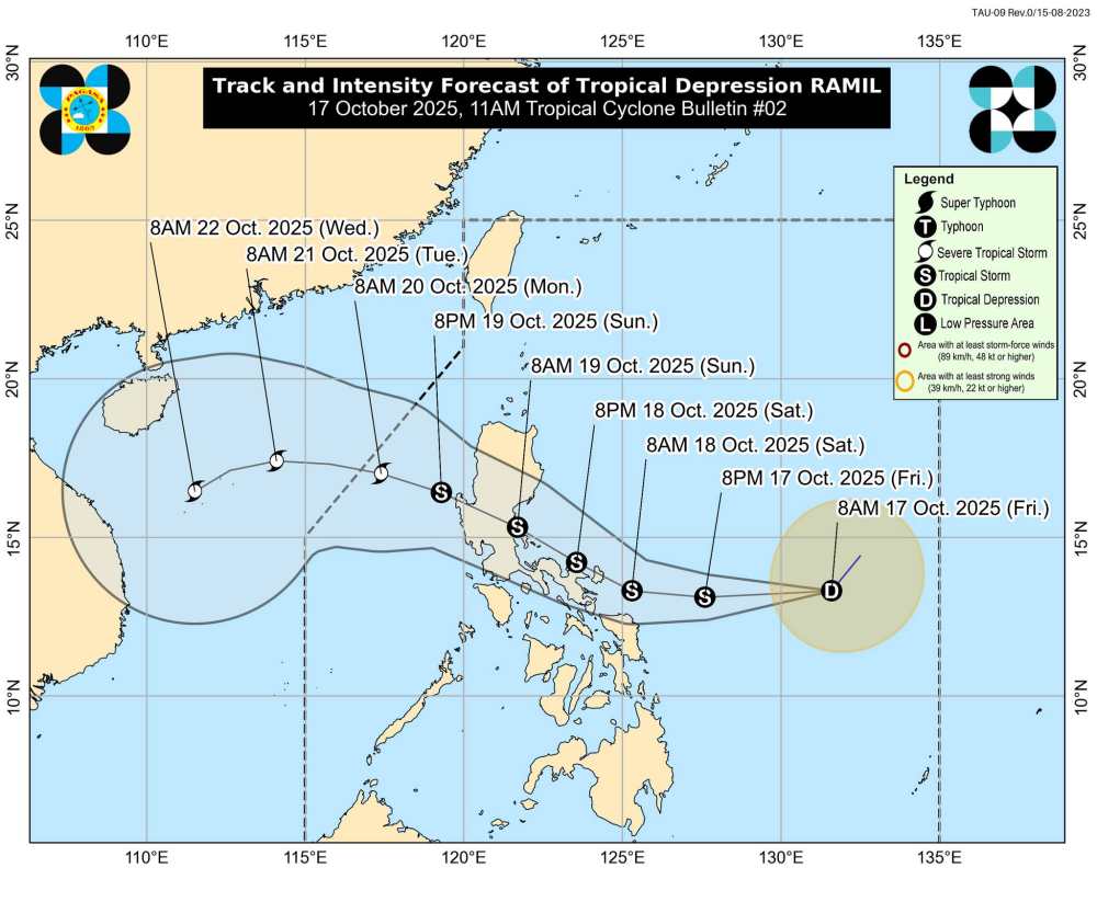
According to the latest weather forecast from the Philippine Atmospheric, Geophysical and Astronomical Services Administration (PAGASA), the low pressure area near the East Sea has strengthened into a tropical depression.

It is forecasted that by 8:00 a.m. this morning (local time), the center of the tropical depression will be at about 13.2 degrees North latitude - 131.2 degrees East longitude, 760 km east of Virac, Catanduanes.

The strongest wind near the center of the tropical depression reached 55 km/h, gusting up to 70 km/h. The low pressure moved slowly in the southwest direction at a speed of 25 km/h, towards the northern area of the East Sea. Strong winds extended outward from the center of the depression up to 350 km.

Due to the influence of the low pressure, the Catanduanes, Albay, Sorsogon, Masbate, Northern Samar, Eastern Samar, and Samar areas will have rain, some places will have heavy to very heavy rain. During thunderstorms, flash floods and landslides may occur.

Cap nhat vi tri cua ap thap nhiet doi sap thanh bao gan Bien Dong. Anh: PAGASA
Updated location of the tropical depression about to become a storm near the East Sea. Photo: PAGASA

According to the National Center for Hydro-Meteorological Forecasting, on the morning of October 17, in the North East Sea area, there were strong Northeast winds of level 4-5. The sea area from Ca Mau to An Giang and the Gulf of Thailand is experiencing scattered showers and thunderstorms.

It is forecasted that on the night of October 17, the northeastern sea area of the North East Sea will have strong winds of level 6, gusting to level 7-8, rough seas. Waves are 2.5 - 3.5m high.

Cap nhat vi tri cua ap thap nhiet doi tren Bien Dong. Anh: PAGASA
Updated location of the tropical depression in the East Sea. Photo: PAGASA

In addition, on the day and night of October 17, the sea area from Quang Tri to Ca Mau, from Ca Mau to An Giang, the Gulf of Thailand, the Central and South East Sea (including the Truong Sa special zone) will have scattered showers and thunderstorms. During thunderstorms, there is a possibility of tornadoes, strong gusts of wind of level 6-7 and waves over 2.0m high.

On the day and night of October 18, the eastern sea area of the North East Sea will have strong northeast winds of level 6, gusting to level 7-8, rough seas. Waves are 2.5-3.5m high.

People and tourists planning to visit these coastal areas should pay attention to weather forecasts. Follow local instructions to avoid storms and large waves at sea that are dangerous.

Khuyen cao cho du khach khi du lich mua bao. Anh: Thanh Son
Recommendations for tourists when traveling during the storm season. Photo: Thanh Son
Chí Long
TIN LIÊN QUAN

New tropical depression is about to form near the East Sea

|

The low pressure near the East Sea is forecast to strengthen into a tropical depression in the next 24 hours.

New low pressure connects low pressure near the East Sea, storm No. 12 is about to appear

|

The new low pressure near the South China Sea approaches the northern mainland of the Philippines, while another low pressure is strengthening near the Philippine area of responsibility.

New low pressure near the East Sea is likely to strengthen

|

The new low pressure has formed near the East Sea, and is likely to strengthen into a tropical depression.

Weather forecast for today, October 13: Low pressure trough causes scattered thunderstorms

|

Weather forecast for today, October 13, the low pressure trough causes thunderstorms at sea, scattered rain across the country.

New tropical depression is about to form near the East Sea

Chí Long |

The low pressure near the East Sea is forecast to strengthen into a tropical depression in the next 24 hours.

New low pressure connects low pressure near the East Sea, storm No. 12 is about to appear

Chí Long |

The new low pressure near the South China Sea approaches the northern mainland of the Philippines, while another low pressure is strengthening near the Philippine area of responsibility.

New low pressure near the East Sea is likely to strengthen

Chí Long |

The new low pressure has formed near the East Sea, and is likely to strengthen into a tropical depression.

Weather forecast for today, October 13: Low pressure trough causes scattered thunderstorms

Chí Long |

Weather forecast for today, October 13, the low pressure trough causes thunderstorms at sea, scattered rain across the country.