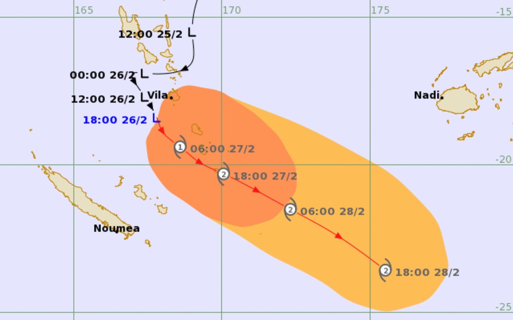
According to the latest low pressure news from the Nadi Tropical Storm Warning Center (Fiji), the low pressure just formed on February 26 quickly reached tropical depression (TD09F) level in 24 hours.
The tropical depression officially became Typhoon Urmil on the morning of February 27 (local time).
Typhoon Urmil is currently about 237km south-southeast of Port Vila (Vanuatu).
The storm has moved in a east-southeast direction at a speed of about 20km/h in the past 6 hours. The maximum sea wave reached about 6.7m, showing that sea conditions are very dangerous.
It is forecast that the storm will bend southeast in the next 24 hours and accelerate towards the pole. The maximum intensity of Typhoon Urmil can reach about 150km/h.
In fact, the central and southern areas of Vanuatu have begun to be affected by bad weather. Heavy rain appeared widely, thick clouds covered most of the territory, accompanied by strong winds. This increases the risk for outdoor tourism and sea transport activities.
Current forecasts show that the center of Typhoon Urmil will remain quite far west of Fiji and will not go directly through the archipelago.
However, the typhoon's circulation may still cause strong winds, gusts and heavy rain in some areas of Fiji from tomorrow.
Tourists who are or are preparing to go to Fiji and Vanuatu need to regularly update weather forecasts and storm warnings from local authorities. Outdoor activities should be limited, especially sea and island tours, diving and traveling by boat during strong winds and heavy rain.
People staying in low-lying or flood-prone areas need to proactively plan flood prevention. Tourists should also check flight schedules, train schedules and backup accommodation plans in case of prolonged bad weather.
Local authorities continue to closely monitor the developments of Typhoon Urmil and recommend that people and tourists maintain high vigilance and comply with safety instructions to ensure that the journey is not interrupted.


