Low pressure relies on low pressure whirlwinding at sea

Chí Long |

2 low pressure areas are forecast to be operating strongly in the Pacific Ocean.

According to storm news, the latest low pressure from the Joint Typhoon Warning Center (JTWC), 2 low pressures are operating in the Pacific Ocean.

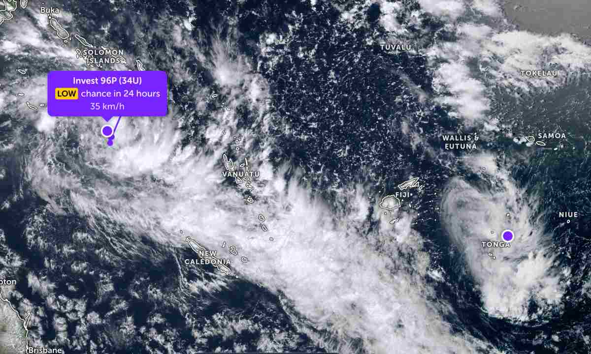
The low pressure bearing the symbol Invest 96P (Tropical Low 34U) is moving in the area north of the Solomon Islands. The strongest wind near the center of the low pressure reaches 35 km/h. The low pressure is unlikely to develop into a tropical depression in the next 24 hours.

At the same time, another low pressure area with the symbol Invest 97P has just formed in the South Pacific region, near the Tonga Island area. The strongest wind near the center of the low pressure area reaches 30 km/h. The low pressure area is unlikely to develop into a tropical depression in the next 24 hours.

The low pressure caused moderate to heavy rain in the sea area and islands in the area.

Áp thấp nối áp thấp hoạt động trên biển. Ảnh: JTWC
Low pressure connects to low pressure (purple dot) operating in the waters of the South Pacific. Photo: JTWC

In the East Sea, according to the National Center for Hydro-Meteorological Forecasting, early this morning, March 16, the sea area east of the Northern East Sea area had strong Northeast winds at level 6.

Forecast for the next 24 hours, the Northeast area of the Northern East Sea will have Northeast wind level 6, gusts level 7-8. Seas are rough. Sea waves are 2.0-4.0m high. Night winds gradually decrease.

The sea area from Khanh Hoa to Vinh Long and the western part of the South East Sea (including the western part of the Truong Sa special zone) has level 5 Northeast wind, sometimes level 6, gusting to level 7-8. Sea is rough. Sea waves are 2.0-3.0m high. Night winds gradually decrease.

Forecast for March 17, winds in sea areas will continue to decrease.

People and tourists planning to visit these sea areas should pay attention to weather forecasts. Follow local instructions and avoid going out when the sea is rough to ensure safety.

Chí Long
TIN LIÊN QUAN

Low pressure has the potential to become a storm, heading towards the mainland

|

Depression 96P over the South Pacific Ocean is likely to strengthen into a tropical depression or tropical storm by the end of the week.

Low pressure moves very quickly at sea

|

Depression 96P just formed in the South Pacific is moving quite fast at a speed of over 30 km/h.

New low pressure area forms at sea

|

Forecast of a new low pressure area just formed in the Pacific Ocean, likely to enter the mainland.

Low pressure strengthens, likely to become a tropical depression

|

It is forecast that the low pressure in the Indian Ocean will continue to strengthen, with the possibility of developing into a tropical depression.

Low pressure has the potential to become a storm, heading towards the mainland

Dương Đông |

Depression 96P over the South Pacific Ocean is likely to strengthen into a tropical depression or tropical storm by the end of the week.

Low pressure moves very quickly at sea

Dương Đông |

Depression 96P just formed in the South Pacific is moving quite fast at a speed of over 30 km/h.

New low pressure area forms at sea

Chí Long |

Forecast of a new low pressure area just formed in the Pacific Ocean, likely to enter the mainland.

Low pressure strengthens, likely to become a tropical depression

Chí Long |

It is forecast that the low pressure in the Indian Ocean will continue to strengthen, with the possibility of developing into a tropical depression.