According to the new low pressure forecast from the Philippine Atmospheric, Geophysical and Astronomical Services Administration (PAGASA), as of 8:00 a.m. on June 24 (local time), the center of the low pressure was at about 15.8 degrees North latitude - 116.6 degrees East longitude, about 365km west of Iba, Zambales.
PAGASA said the low pressure has a probability of developing into a tropical depression in the next 24 hours.
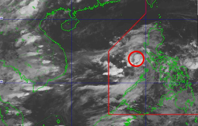
Due to the influence of the low pressure, the Pangasinan, Zambales, Bataan, Metro Manila, Zamboanga Peninsula and the rest of Central Luzon in the Philippines will experience gloomy skies with scattered thunderstorms.
moderate to heavy rains can cause flooding or landslides in the area.
The low pressure trough in the East Sea affects Vietnam's marine weather.
According to the National Center for Hydro-Meteorological Forecasting, the low pressure trough has an axis through the Central East Sea, on Phu Quy island there are southwest winds of level 5, sometimes level 6.
Forecast for the day and night of June 24, the eastern sea area of the North East Sea, the Central and South East Sea (including the Truong Sa archipelago), the sea area from Binh Thuan to Ca Mau, Ca Mau to Kien Giang and the Gulf of Thailand will have showers and thunderstorms.
During thunderstorms, tornadoes and strong gusts of wind of level 6-7 may occur. Waves are over 2.0m high.
In particular, the sea area from Binh Thuan to Ca Mau has southwest winds of level 5, sometimes level 6, gusting to level 7. Waves are 1.5-2.5m high, with rough to moderate seas.
Ship operating in the above areas are at high risk of tornadoes and strong gusts of wind.
People and tourists need to proactively prevent natural disasters and follow updated news. Follow local recommendations to ensure safety.


