According to storm news, the latest low pressure from the Philippine Atmospheric, Geophysical and Astronomical Services Administration (PAGASA), Typhoon Bavi is strongly strengthening near the East Sea.
As of 2 pm today (local time), the storm's center is located at about 12.9 degrees North latitude - 154.2 degrees East longitude, about 3,210 km east of the Eastern Visayas.
The strongest wind near the storm center reaches 150 km/h, gusting up to 185 km/h. The storm moves in a westerly direction at a speed of 20 km/h. The maximum wave height reaches 11 m.
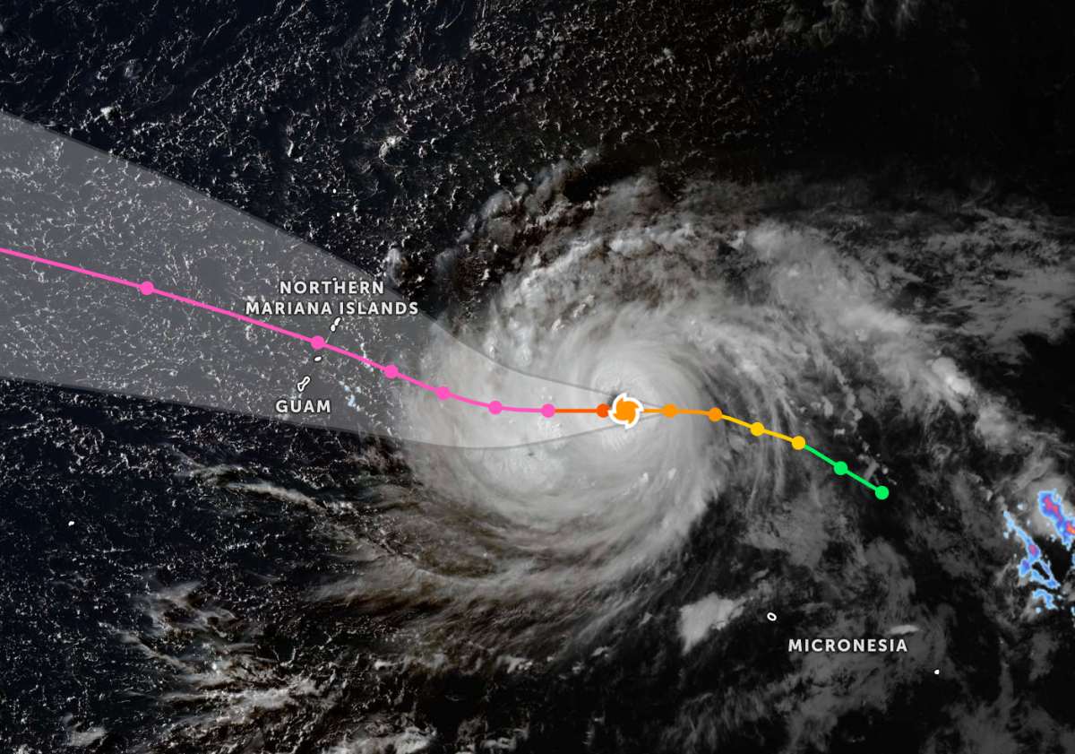
The Joint Typhoon Warning Center (JTWC) forecasts that in the next 24 hours, the storm's moving speed will slow down as the mid-latitude trough weakens the subtropical high pressure. After that, the storm will continue to move slowly in a westerly direction for about 36 hours before accelerating again after about 3 days.
In terms of intensity, Typhoon Bavi is entering a period of rapid intensification. Environmental conditions in the next 2 days are assessed to be very favorable, helping the typhoon to reach a maximum intensity of about 280 km/h, meeting the super typhoon threshold.
Experts believe that the rapid strengthening process may also cause the storm to enter an early cycle of replacing it as a storm eye. However, the starting time, duration, and extent of this process's impact on storm intensity are still undetermined.
Although Bavi is large in scale and very strong, Typhoon Bavi is forecast to gradually weaken after about 3 days.
In the East Sea, storm No. 1 Maysak is operating strongly. At 13:00 on July 3, the center of storm No. 1 was located at about 17.6 degrees North latitude - 109.9 degrees East longitude, about 90km south of Hainan Island (China).
The strongest wind near the storm center is strong at level 8-9 (62-88 km/h), gusting at level 11. The storm is moving slowly in a West-Northwest direction at a speed of about 7km/h.
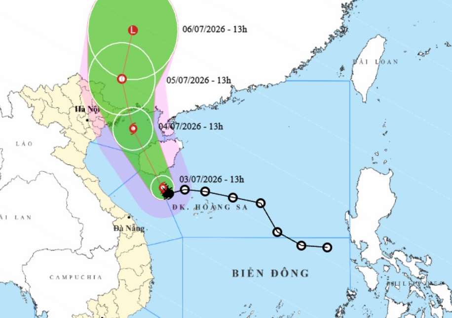
Forecast until 13:00 on July 4, the storm will move in a North-Northwest direction at a speed of about 15 km/h. The storm's center is in the Northern Gulf of Tonkin area, at a position of about 20.6 degrees North latitude - 108.3 degrees East longitude, about 170 km south-southeast of Mong Cai (Quang Ninh).
The strongest wind in the area near the storm center reached level 8-9, gusting to level 11. The dangerous area at sea is located north of latitude 16.0 degrees North latitude, from 106.5 to 112.0 degrees East longitude. Disaster risk level 3, affecting the west of the Northern East Sea area (including Hoang Sa special zone), the northeastern sea area from southern Quang Tri to Quang Ngai and the Gulf of Tonkin (including Bach Long Vi, Van Don, Co To, Cat Hai special zones and Hon Dau island).
Due to the impact of the storm, the sea area west of the Northern East Sea area (including Hoang Sa special zone) and the sea area northeast of the area from South Quang Tri to Quang Ngai; from the night of July 3 expanding to the Gulf of Tonkin (including Bach Long Vy, Van Don, Co To, Cat Hai and Hon Dau island special zones) has strong winds of level 6-7, near the storm center level 8-9, gusts of level 11; sea waves 2.0-4.0m high; very rough seas.
The coastal areas of Quang Ninh, Hai Phong and Hung Yen provinces from the afternoon of July 4th will have strong winds of level 6, near the storm center level 7-8, gusts of level 9-10; sea waves 2.0-3.0m high; storm surge of about 0.2-0.4m.
Strong winds can blow off roofs, damage temporary structures, break down green trees, billboards; affect electrical systems, communication and traffic. Large waves combined with rising water can cause localized flooding in river mouths, tidal flats and low-lying areas; affect dykes, seawalls and coastal works.
From tonight, the Northeast region and Thanh Hoa will have heavy to very heavy rain, common rainfall of 100-200mm; especially the Northeast region 200-300mm, locally over 500mm.
Heavy rain may cause flooding in urban areas, industrial parks and low-lying areas; increasing the risk of floods on small rivers and streams, flash floods and landslides in mountainous areas.
People and tourists in these areas should pay attention to weather forecasts. Follow local instructions to avoid storms causing impact.


