According to the National Center for Hydro-Meteorological Forecasting, at 1:00 p.m. on November 4, the center of storm Kalmaegi was at about 10.7 degrees North latitude - 122.0 degrees East longitude, in the central Philippines. The strongest wind near the storm center is level 13 (134 - 149 km/h), gusting to level 16.
It is forecasted that in the next 24 hours, the storm will move west at a speed of about 25 km/h.
By 1:00 p.m. on November 5, the storm will move west-northwest at a speed of 20 - 25 km/h and enter the East Sea, becoming the 13th storm to operate in this area this year. At this time, the center of the storm was at about 11.8 degrees North latitude - 117.2 degrees East longitude, in the sea east of the central East Sea.
The strongest wind near the storm center is level 13, gusting to level 16. Natural disaster risk level: level 3 for the eastern sea area of the central East Sea.
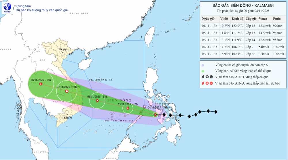
At 1:00 p.m. on November 6, the storm continued to move in a West-Northwest direction at a speed of about 25 km/h. The center of the storm is expected to be at about 13.1 degrees North latitude - 111.9 degrees East longitude, in the central East Sea, about 320 km east-southeast of the Gia Lai province coast.
The storm is forecast to strengthen, reaching level 14, gusting to level 17. The natural disaster risk level has been raised to level 4, including the area between the East Sea (including the sea area north of Truong Sa archipelago) and the sea area from Da Nang to Khanh Hoa (including Ly Son island).
By 1:00 p.m. on November 7, the storm is forecast to move in a West-Northwest direction at a speed of about 25 km/h, moving deep into the mainland of Southern Laos. The center of the storm is located at about 14.7 degrees North latitude - 106.6 degrees East longitude.
The storm will gradually weaken into a tropical depression, with a reduced intensity of level 7, gusting to level 8. The natural disaster risk level remains at level 4, affecting the western sea area between the East Sea, the sea area from Da Nang to Khanh Hoa (including Ly Son), as well as the coastal mainland from Quang Ngai to Dak Lak.
In the next 72 to 96 hours, the tropical depression will move mainly in the West Northwest direction, traveling 20 - 25 km per hour, and gradually weaken into a low pressure area when it reaches the mainland.
Due to the influence of the storm, at sea, from November 5 to 6, the central East Sea area, including the sea area north of Truong Sa archipelago and offshore from Da Nang to Khanh Hoa, will have strong winds of level 12 - 14, gusting above level 17. Waves are 8 - 10m high, the sea is very rough. Previously, the eastern sea area of the central East Sea had winds gradually increasing to level 6 - 7, then increasing to level 8 - 10; the area near the storm's eye was strong at level 11 - 13, gusting to level 15 - 16, waves 5 - 7m high.
All ships and vehicles operating in the dangerous area are advised to urgently seek safe shelter and closely monitor the storm's developments to proactively avoid strong winds, big waves, and thunderstorms. Coastal localities from Da Nang to Khanh Hoa need to prepare response plans, ensuring safety for people, tourists, boats and works at sea.
People and tourists should avoid going outside when not necessary during the storm, which directly affects the weather at sea and on land in Vietnam. Tuan follows local instructions to ensure safety.


