According to the latest storm news from the Joint Typhoon Warning Center (JTWC), on January 11, Typhoon Dudzai strengthened into a typhoon in the Indian Ocean.
As of the morning of January 12, the center of Typhoon Dudzai is located about 1,124 km south-southeast of Diego Garcia. In the past 6 hours, the typhoon has moved in a Southeast direction at a speed of 11 km/h. The maximum wave height reached 6.1 m.
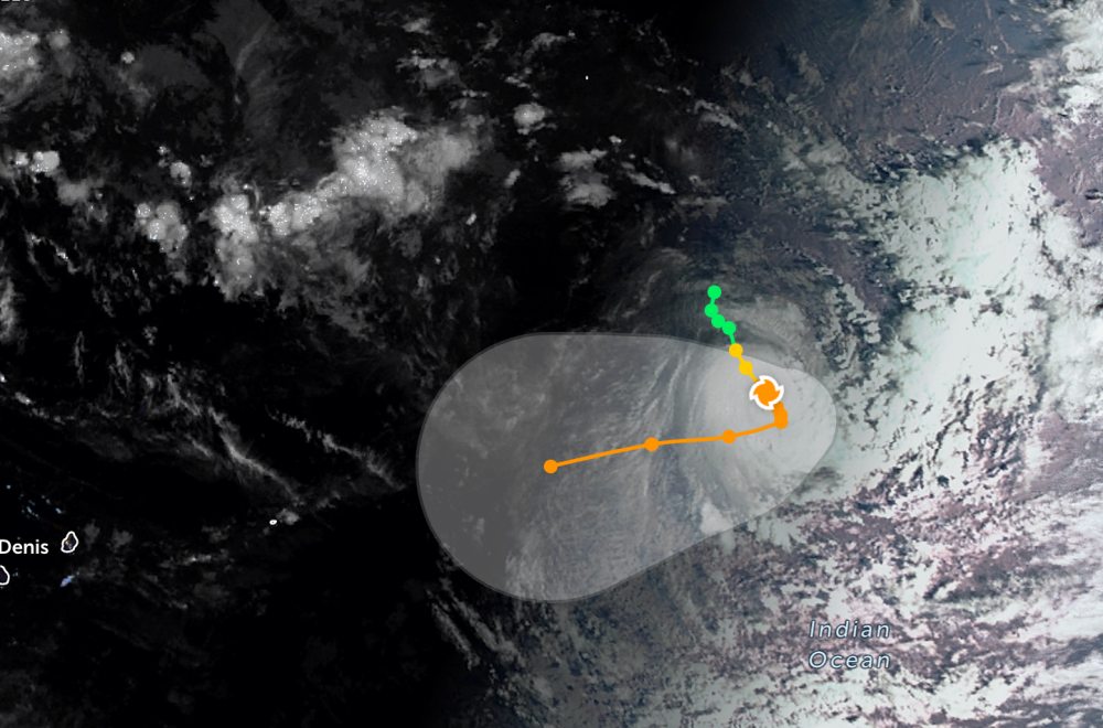
The strongest wind near the storm center reaches 140 km/h. Forecast for the next 24 hours, storm Dudzai will continue to move in the South - Southeast direction and continue to strengthen rapidly. The maximum wind speed may exceed 175 km.
The storm's movement speed is expected to slow down significantly, with the possibility of Dudzai almost standing still after about the next 24 hours. In the next 1-2 days, storm Dudzai will change direction to the West - Southwest.
Meanwhile, in the East Sea, according to the National Center for Hydro-Meteorological Forecasting, on the morning of January 12, Phu Quy special zone had gusts of level 7; Huyen Tran station had strong Northeast winds of level 6, sometimes level 7, gusts of level 8.
Forecast for the day and night of January 12, the eastern sea area of the Northern East Sea, the sea area from Gia Lai to Ca Mau and the western sea area of the South East Sea (including the western sea area of the Truong Sa special zone): Northeast wind level 6, gusts level 7-8; rough seas; waves 2.0-4.0m high.
On the day and night of January 13, 2026, the northeastern sea area of the Northern East Sea, the sea area from Khanh Hoa to Ca Mau and the western sea area of the South East Sea (including the western sea area of the Truong Sa special zone): strong Northeast wind level 6, gusts level 7-8; rough seas; waves 2.0-4.0m high. Level of natural disaster risk at sea: level 2.
People and tourists who plan to go to the above sea areas or areas affected by storms, low pressures... should pay attention to weather forecasts. Avoid going out to sea when the sea is rough to ensure safety.