Typhoon Koji officially makes landfall, heavy rain and floods

Ninh Phương |

Typhoon Koji made landfall on the coast of Northern Queensland on the morning of January 11, causing heavy rain, strong winds and flash floods in many coastal areas and famous tourist destinations in Australia.

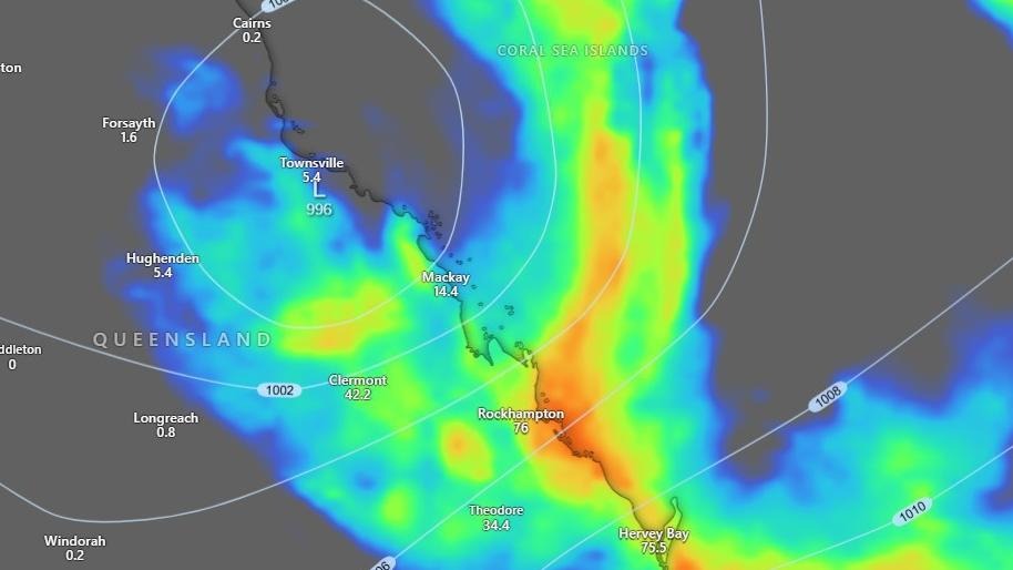
Typhoon Koji officially made landfall in the area between Townsville and Bowen, then weakened into a tropical depression at about 10 am on January 11 (local time). However, the risk of dangerous flooding is still high.

According to the latest storm news from the Australian Meteorological Agency, gusts of wind at times reached 100 km/h, knocking down trees, fences and disrupting traffic as the storm moves in a South-Southwest direction.

Areas from Bowen to Mackay, including Whitsunday Islands, Proserpine and Airlie Beach, are directly affected.

Very heavy rain was recorded after Typhoon Koji made landfall. In Gargett, near Mackay, 146 mm of rain in just two hours caused many roads to be blocked and river levels to rise rapidly. Some residential areas in Marian, west of Mackay, recorded gardens and houses flooded.

Du bao vung mua mo rong, kem nguy co lu quet trong nhung ngay toi tai Queensland, Australia du bao Koji da suy yeu thanh ap thap nhiet doi. Anh: Windy
Forecast of widening rain area, accompanied by flash flood risk in the coming days in Queensland, Australia even though Typhoon Koji has weakened into a tropical depression. Photo: Windy

At coastal tourist destinations like Whitsundays, strong winds and torrential rain have caused many outdoor activities, boats and sea tours to be temporarily suspended. Some boats have broken anchors or are stranded in the Airlie Beach area.

Queensland authorities confirmed that many emergency rescues have taken place. A mother and two children were rescued from a car trapped in floodwaters near Bowen. Off the coast of Cannonvale, a ship sank, and two people had to swim ashore to escape.

The meteorological agency warns that rainfall in the next 24 hours may reach 100-250 mm, in some places up to 340 mm, increasing the risk of widespread flooding in tourist areas and coastal residential areas.

Tourists who are staying or planning to visit Townsville, Bowen, Proserpine, Whitsundays, Mackay should closely follow the weather forecast and low pressure, storm warning.

Ninh Phương
TIN LIÊN QUAN

Typhoon Dudzai is about to strengthen to a hurricane level, going around

|

Typhoon Dudzai is forecast to have a complex direction, with continuous winds increasing in the Indian Ocean.

Tropical depression officially becomes Typhoon Koji, about to make landfall

|

The tropical depression strengthens into Typhoon Koji off the coast of Queensland, Australia. It is forecast that the typhoon will make landfall with Category 2 intensity in less than 24 hours.

Tropical depression about to strengthen into a storm heading towards the mainland

|

It is forecast that a tropical depression in the Indian Ocean is likely to strengthen into a storm in the next 24 hours.

Typhoon Jenna changes direction at sea, waves are over 7m high

|

Typhoon Jenna is forecast to change direction in the Indian Ocean, wind speed exceeding 100 km/h.

Typhoon Dudzai is about to strengthen to a hurricane level, going around

Chí Long |

Typhoon Dudzai is forecast to have a complex direction, with continuous winds increasing in the Indian Ocean.

Tropical depression officially becomes Typhoon Koji, about to make landfall

Ninh Phương |

The tropical depression strengthens into Typhoon Koji off the coast of Queensland, Australia. It is forecast that the typhoon will make landfall with Category 2 intensity in less than 24 hours.

Tropical depression about to strengthen into a storm heading towards the mainland

Chí Long |

It is forecast that a tropical depression in the Indian Ocean is likely to strengthen into a storm in the next 24 hours.

Typhoon Jenna changes direction at sea, waves are over 7m high

Chí Long |

Typhoon Jenna is forecast to change direction in the Indian Ocean, wind speed exceeding 100 km/h.