Typhoon Dudzai is about to strengthen to a hurricane level, going around

Chí Long |

Typhoon Dudzai is forecast to have a complex direction, with continuous winds increasing in the Indian Ocean.

According to the latest storm news from the Joint Typhoon Warning Center (JTWC), on January 11, Typhoon Dudzai continued to strengthen rapidly in the Indian Ocean.

As of the afternoon of January 11, the center of Typhoon Dudzai is located about 1,006 km south-southeast of Diego Garcia. In the past 6 hours, the typhoon has moved in a Southeast direction at a speed of 13 km/h. The maximum wave height reached 5.5 m.

The strongest wind near the storm center reaches 100 km/h. Forecast for the next 24 hours, storm Dudzai will continue to move in a Southeast direction and continue to strengthen rapidly.

Du bao bao Dudzai sap manh len cap cuong phong tren bien An Do Duong. Anh: JTWC
Typhoon Dudzai is forecast to strengthen to a typhoon level in the Indian Ocean. Photo: JTWC

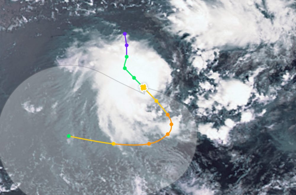
It is forecast that by the evening of January 12, storm Duzai will slow down and turn sharply to the Southwest. In the next 12 hours, the storm will shift direction to the West.

In terms of intensity, Typhoon Dudzai is forecast to quickly strengthen in the next 36 hours due to favorable environmental conditions. The maximum intensity is forecast to be about 155 km/h, reaching typhoon level before the system shifts westward. Even, JTWC forecasts that the maximum intensity of the typhoon may be even higher.

Due to being quite far from the mainland, Typhoon Dudzai does not affect tourist destinations in the area. However, the storm caused rough seas and big waves.

People and tourists who plan to go to the sea areas where the storm passes should pay attention to weather forecasts. Avoid going out to sea when the sea is rough and follow local instructions to ensure safety.

Chí Long
TIN LIÊN QUAN

The new low pressure suddenly becomes Typhoon Dudzai, strengthening to a maximum in the next 48 hours

|

A low pressure area over the Indian Ocean has rapidly developed into a tropical storm Dudzai in about 48 hours.

Typhoon Koji officially makes landfall, heavy rain and floods

|

Typhoon Koji made landfall on the coast of Northern Queensland on the morning of January 11, causing heavy rain, strong winds and flash floods in many coastal areas and famous tourist destinations in Australia.

Tropical depression officially becomes Typhoon Koji, about to make landfall

|

The tropical depression strengthens into Typhoon Koji off the coast of Queensland, Australia. It is forecast that the typhoon will make landfall with Category 2 intensity in less than 24 hours.

The new low pressure suddenly becomes Typhoon Dudzai, strengthening to a maximum in the next 48 hours

Ninh Phương |

A low pressure area over the Indian Ocean has rapidly developed into a tropical storm Dudzai in about 48 hours.

Typhoon Koji officially makes landfall, heavy rain and floods

Ninh Phương |

Typhoon Koji made landfall on the coast of Northern Queensland on the morning of January 11, causing heavy rain, strong winds and flash floods in many coastal areas and famous tourist destinations in Australia.

Tropical depression officially becomes Typhoon Koji, about to make landfall

Ninh Phương |

The tropical depression strengthens into Typhoon Koji off the coast of Queensland, Australia. It is forecast that the typhoon will make landfall with Category 2 intensity in less than 24 hours.