According to the latest storm news from the Joint Typhoon Warning Center (JTWC), on December 27, Typhoon Grant strengthened to a hurricane level. The center of Typhoon Grant is located 1,815 km east-southeast of Diego Garcia. In the past 6 hours, the storm has moved in a westerly direction at a speed of 17 km/h. The maximum wave height reached 6.7m.
The strongest wind near the storm center reaches 110 km/h. It is forecast that the storm will continue to move in a East-Southeast direction, towards Madagascar and strengthen rapidly.
JTWC forecasts that by December 29, the storm will have a maximum intensity of 140 km/h and continue to strengthen to 150 km/h in the following days.
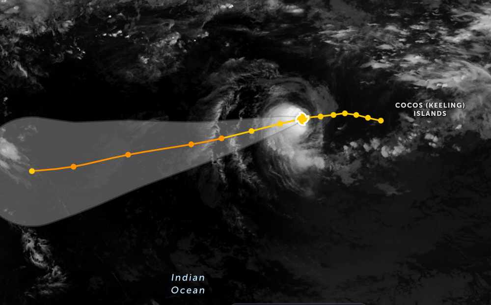
Due to being quite far from the mainland, Typhoon Grant only caused heavy rain and big waves in the Indian Ocean, and has not had much impact on adjacent mainland areas.
In the East Sea, according to the National Center for Hydro-Meteorological Forecasting, from the night of December 27 to 28, the sea area east of the Northern East Sea area will have strong Northeast winds at level 6, gusting at level 7; rough seas, sea waves from 2.0 to 4.0m high; wind gradually decreases during the day. The Central East Sea area will have strong Northeast winds at level 5, sometimes level 6, gusting at level 7; rough seas, sea waves from 2.0 to 4.0m high.
The western sea area of the South China Sea, including the western sea area of the Truong Sa special zone, and the sea area from Dak Lak to Ca Mau have strong Northeast winds at level 6, sometimes level 7, gusts at level 8-9; rough seas, waves 3.0 to 5.0m high.
In addition, on the night of December 27th and December 28th, the South East Sea area (including Truong Sa special zone), Ca Mau to An Giang sea area and the South of the Gulf of Thailand will have scattered showers and thunderstorms. In thunderstorms, there is a possibility of tornadoes and strong gusts of wind at level 6-7.
On the night of December 28th and December 29th, the sea area from Khanh Hoa to Ca Mau and the sea area west of the South China Sea (including the sea area west of the Truong Sa special zone) will have strong Northeast winds at level 6, gusts at level 7-8; rough seas; waves 2.0-5.0m high.
People and tourists who plan to visit these sea areas should pay attention to weather forecasts. Avoid going out to sea when the sea is rough and follow local instructions to ensure safety.


