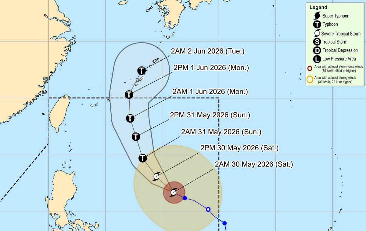
According to the latest low pressure bulletin from the Philippine Atmospheric, Geophysical and Astronomical Services Administration (PAGASA), in the early morning of May 30, Typhoon Jangmi (local name Domeng) continued to strengthen fiercely in the Philippine Sea.
At 4 am on May 30, the storm center was located at about 16.9 degrees North latitude - 130.8 degrees East longitude, about 970 km east of Northern Luzon. The strongest wind in the area near the storm center reached 95 km/h, gusting up to 115 km/h. The storm is moving in a Northwest direction at a speed of 15 km/h. The area of strong winds from level 6 and above expands within a radius of 460 km from the storm center.
PAGASA forecasts that the storm will continue to strengthen in the next 24 hours and is likely to reach typhoon level.
Due to the influence of the storm's circulation combined with the Southwest monsoon, many areas in the Philippines are at risk of strong to very strong winds.
On May 30, strong gusts may affect most of the Visayas, Batanes, Cagayan, Pangasinan, Zambales, Bataan, Tarlac, Nueva Ecija, Bulacan, CALABARZON, MIMAROPA, Bicol and some provinces in Mindanao. On May 31 and June 1, the scope of strong winds' influence will still be maintained over a wide area in many coastal and island areas of the Philippines.
At sea, Typhoon Jangmi caused rough seas from moderate to strong in many sea areas in the East and North of the Philippines. In the sea area east of the Batanes and Babuyan archipelagoes, sea waves can reach up to 3.5 m high. Many other sea areas recorded waves from 2 - 3 m high.
Regarding the movement trend, PAGASA forecasts that Typhoon Jangmi will change direction to the Northwest from this morning or afternoon and maintain this direction until the end of May 31. After that, the typhoon is likely to change direction to the Northeast, advancing towards the South of Japan in the next forecast period.
The Philippine meteorological agency assessed that the storm is unlikely to make landfall in the Philippines and is expected to leave the country's forecasting responsibility area on June 1.
Notably, Typhoon Jangmi is forecast to continue to strengthen during its activity in the Philippine waters and may reach typhoon level on the night of May 30 or morning of May 31. After reaching maximum intensity, the typhoon will gradually weaken but still maintain typhoon level in the following days.
PAGASA notes that heavy rain, strong winds and dangerous weather phenomena may still appear outside the main forecast area of the storm because the trajectory and intensity may continue to change. People and tourists planning to visit high-risk areas are advised to closely monitor meteorological forecasts and implement disaster prevention instructions from functional agencies.


