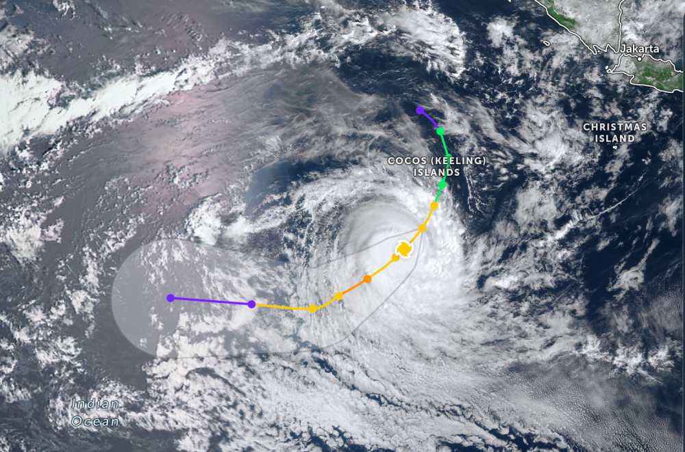
According to the latest storm news from the Joint Typhoon Warning Center (JTWC), on the morning of January 6, Typhoon Jenna (symbol 12S) continued to intensify.
The center of the storm is located 259 km south-southwest of the Cocos Islands (Australia). In the past 6 hours, the storm has moved in a South-Southwest direction at a speed of 22 km/h. The maximum wave height reached 7.6 m.
The strongest wind near the storm center reached 120 km/h. Typhoon Jenna is forecast to continue to strengthen in the next 24 hours with maximum winds of up to 140 km/h.
When reaching the east of the Cocos Islands, Typhoon Jenna will maintain its South-Southwest orbit. The direction of the typhoon will draw a gentle curve in a Southwest direction for the next 36 hours.
Meanwhile, in the East Sea, according to the National Center for Hydro-Meteorological Forecasting, on the morning of January 6, in the Gulf of Tonkin, there was strong Northeast wind at level 6, gusting at level 7; Phu Quy special zone had gusts at level 7; Huyen Tran station had strong Northeast wind at level 6, gusting at level 8. The sea area northeast of the Northern East Sea area had strong Northeast wind at level 6. The low pressure trough in the South has an axis of about 4-6 degrees North latitude.
Forecast for today and tonight, in the Gulf of Tonkin there will be Northeast wind level 6, sometimes level 7, gusts level 8-9; waves 2.5-3.5 m high; strong sea waves, gradually decreasing winds at night.
Northern East Sea area (including Hoang Sa special zone): Strong Northeast wind level 6-7, gusts level 8-9; waves 3.0-5.0 m high; strong rough seas.
Sea area from Khanh Hoa to Ca Mau and the western sea area of the South East Sea (including the western part of Truong Sa special zone): Northeast wind level 6, sometimes level 7, gusts level 8-9; wave height 4.0-6.0 m; strong rough seas.
Sea area from South Quang Tri to Dak Lak and the Central East Sea area: Northeast wind level 6, gusts level 7-8; waves 2.0-5.0 m high; rough seas.
In addition, on the day and night of January 6, the Central and South East Sea areas (including Truong Sa special zone) will have scattered showers and thunderstorms; in thunderstorms, there is a possibility of tornadoes and strong gusts of wind.
On January 7, day and night, the North East Sea area (including Hoang Sa special zone), the sea area from Khanh Hoa to Ca Mau and the sea area west of the South East Sea area will have strong Northeast winds at level 6, sometimes level 7, gusts at level 8-9; waves 3.0-6.0 m high; strong rough seas.
The sea area from South Quang Tri to Dak Lak and the Central East Sea area will have strong Northeast wind at level 6, gusts at level 7-8; waves 3.0-5.0 m high; rough seas.
People and tourists who plan to visit the above sea areas should pay attention to weather forecasts. Avoid going out to sea when the sea is rough and follow local instructions to ensure safety.


