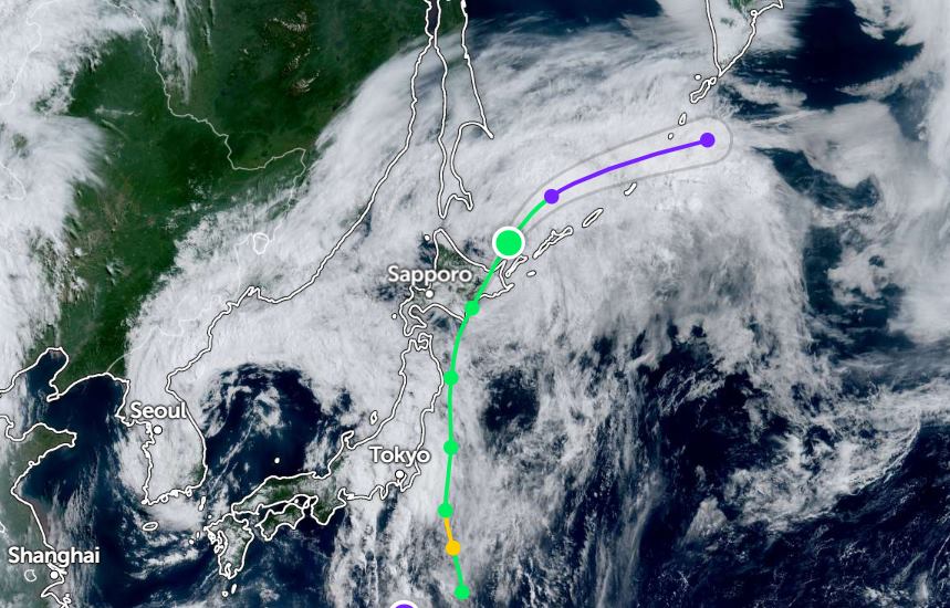
The Japan Meteorological Agency said that tropical storm Nari made landfall in the Erimo Cape area of Hokkaido at around 2am this morning (July 15, local time).
Strong winds are expected to blow over northern Japan. Authorities have warned of rough sea conditions offshore in this area.
Hokkaido is likely to see heavy rain and thunderstorms, with some areas expected to see up to 12 inches (120 mm) of rain over the next 24 hours.
People and tourists in the area need to be on guard against strong winds, big waves, landslides, flooding in low-lying areas and rising river levels.
Meanwhile, the weather in eastern Japan is extremely unstable due to a low pressure area over the Sea of Japan combined with warm, moist air blowing in. The thick rain clouds are moving up from the South.
On the morning of July 15, Fuji City, Shizuoka Prefecture, recorded 51mm of rain. The city of Okazaki in Aichi Prefecture also received 35mm of rain.
The Suruga area of Shizuoka city was affected by strong gusts of wind like a dragon's feet on the evening of July 14. Local authorities have issued a warning about these weather conditions.
Weather conditions in Tokai and Kanto-Koshin are expected to continue to be highly unstable, with the possibility of very heavy rain and thunderstorms in some places.
The weather in the provinces of the Tokai region, including Aichi, Gifu and Shizuoka, is cloudy until noon today, July 15.
In the next 24 hours, the Tokai and Kanto-Koshin regions are forecast to receive up to 150mm of rain. In the next 24 hours, by Thursday morning, the Tokai area could receive an additional 200mm, while Kanto-Koshin is expected to receive an additional 150mm.
Authorities continue to warn about landslides, flooding in low-lying areas, rising rivers, as well as lightning, strong gusts of wind like dragon fruit and hail.
Tourists planning to travel to Japan and areas affected by Typhoon Nari during this time should pay attention to weather forecasts. Follow the instructions of local authorities and prevent natural disasters.


