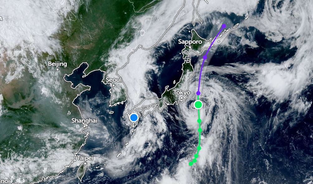
According to the latest storm news, storm Nari has strengthened. On the morning of July 14, the center of the storm was at about 34.1 degrees North latitude - 142.2 degrees East longitude, about 230 km from Yokosuka, Japan. The storm is moving north at a speed of about 39km/h.
At 1:00 a.m. on July 14, the strongest wind near the center of the storm reached 95 km/h, gusting up to 120 km/h. Waves in the storm's sea area are up to 7m high, rough seas.
The Joint Typhoon Warning Center (JTWC) forecasts that severe tropical storm Nari will intensify to its peak at 1:00 p.m. on July 14, with sustained winds of about 101 km/h and gusts of up to 130 km/h.
The storm is expected to continue to strengthen and move closer to Japan's Ogasawara Islands. The storm is likely to approach the Izu Islands and then the Kanto area tomorrow morning.
The storm is also expected to approach the Saporo area (Japan) tomorrow, July 15.
Due to the impact of Typhoon Nari, heavy rain and thunderstorms, strong gusts of wind are expected in the Ogasawara Islands and the Izu Islands as well as the Kanto area.
Meanwhile, a tropical depression is moving inland in the Kagoshima and Fukouka (Japan) with winds of 45km/h.
In the sea area of Vietnam, according to the National Center for Hydro-Meteorological Forecasting, today, July 14, the South East Sea area (including Truong Sa special zone), the sea area from Lam Dong to Ca Mau and the Gulf of Thailand will have scattered showers and thunderstorms.
On the day and night of July 14, scattered showers and thunderstorms occurred in the northern areas of the Gulf of Tonkin, the Central and South East Sea (including the Truong Sa special zone), the sea area from Lam Dong to Ca Mau, from Ca Mau to An Giang, the Gulf of Thailand.
During thunderstorms, there is a possibility of tornadoes and strong gusts of wind. Waves are over 2m high.
People and tourists planning to visit the above sea areas, the area where storm Nari passed through, should pay attention to weather forecasts and check flight schedules to comply with local instructions to ensure safety.


