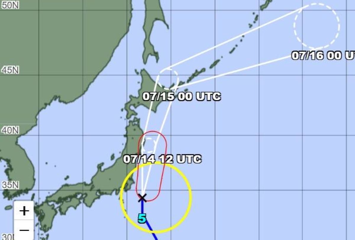
According to the Japan Meteorological Agency (JMA), as of 10:00 a.m. on July 14, the center of storm Nari was about 180 km southeast of Choshi (Chiba Prefecture), in the West Pacific. The storm is moving north at a speed of about 35km/h.
Maximum winds near the center of the storm reached 90 km/h and reached maximum gusts of up to 126 km/h. Winds of more than 54 km/h were recorded within a radius of up to 500 km from the center of the storm.
The storm is expected to move through an area about 140 km southeast of Ishinomaki City, Miyagi Prefecture, at 6:00 p.m. today, July 14. Maintained winds are forecast to increase to 108 km/h, with gusts of up to 144 km/h.
Strong winds of over 90 km/h, the radius of strong winds may extend to 185 km to the East and 110 km to the West of the storm's center.
By 6:00 a.m. on July 15, Nari is expected to make landfall in the area about 80 km west of Abashiri City, Hokkaido. At this time, the storm is expected to weaken somewhat. Maintained winds may drop to 65 km/h, with gusts of up to about 90 km/h.
The storm is expected to transition into a tropical cyclone in the Okhotsk Sea after crossing northern Japan.
On July 15, Hokkaido is expected to have sustained winds of 83 km/h and gusts of up to 126 km/h. In Tohoku, winds could reach 72 km/h, gusting up to 90 km/h.
Typhoon Nari brought heavy rain and thunderstorms in many places. From now until 6am on July 15, total rainfall could reach 120mm in Kanto-Koshin, Tohoku, and Ogasawara Islands, while Hokkaido could reach 100mm.
From 6am on July 15 to 6am on July 16, total rainfall could reach 150mm in Kanto-Koshin and 80mm in Hokkaido.
Hurricane Nari also caused rough seas, especially along the Pacific coast. On July 14, waves could reach 7m in the Tohoku sea, 6m in the Kanto area and 4m around Izu and Ogasawara.
By July 15, wave heights are expected to remain at 7m in both Hokkaido and Tohoku, slightly dropping to 5m in Kanto and the Izu Islands, and remaining at 4m near the Ogasawara Islands.
People and tourists in Japan should continue to monitor updates from the JMA and local Japanese authorities, especially with travel instructions, cancellations or delays of flights, ships, and measures to prevent storms, floods, and big waves.
Note the expected time the storm will pass (afternoon of July 14 through Tohoku - Kanto, morning of July 15 through Hokkaido local time) to adjust the plan.


