Storm No. 1 travels around the East Sea, forecast to continue to strengthen

Chí Long |

The tropical depression in the East Sea has strengthened into storm No. 1 and is forecast to continue to strengthen.

According to the National Center for Hydro-Meteorological Forecasting, on the morning of June 11, the tropical depression in the eastern area of Hoang Sa archipelago strengthened into a storm, storm No. 01 in 2025, with the international name WUTIP.

The center of the storm is located at about 16.1 degrees North latitude - 113.7 degrees East longitude, in the sea east of Hoang Sa archipelago. Strong wind intensity level 8 (62-74km/h), gust level 10.

The storm moved slowly in the West Northwest direction, at a speed of 5-10km/h.

Bao so 1 di duong vong tren Bien Dong, tiep tuc manh len. Anh: Trung tam Du bao Khi tuong Thuy van quoc gia
Storm No. 1 is moving around the East Sea, continuing to strengthen. Photo: National Center for Hydro-Meteorological Forecasting

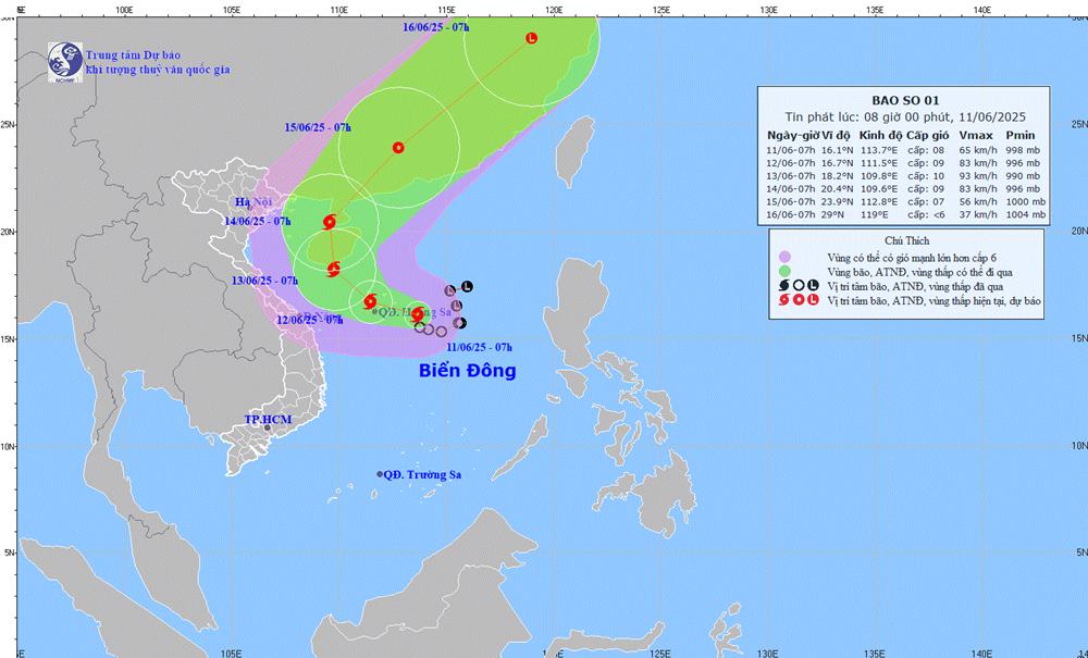
It is forecasted that by 7:00 a.m. on June 12, storm No. 1 will move in the West Northwest direction, about 10 km/h and is likely to strengthen. The center of the storm is located at about 16.7 degrees North latitude - 111.5 degrees East longitude in the Hoang Sa archipelago.

Strong wind intensity level 9, gust level 11. Disaster risk level: level 3 for the North East Sea area (including Hoang Sa archipelago).

By 7:00 a.m. on June 13, the storm will move northwest at a speed of about 5-10 km/h and is likely to strengthen. The center of the low pressure is located at about 18.2 degrees North latitude - 109.8 degrees East longitude, in the area south of Hainan Island (China). The strongest wind intensity is level 10, gusting to level 13.

Natural disaster risk level: level 3 in the North East Sea (including Hoang Sa archipelago) and offshore waters from Quang Tri to Quang Ngai, the sea area east of the Gulf of Tonkin.

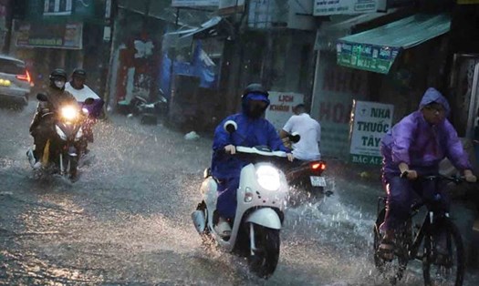
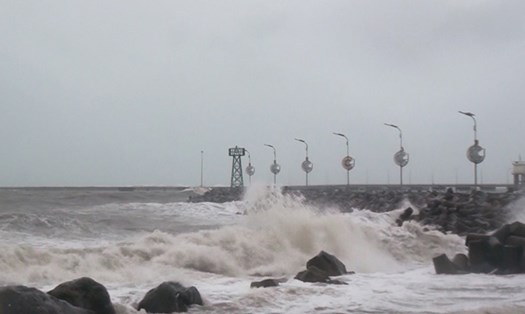
Due to the influence of storm No. 1, the North East Sea area (including the Hoang Sa archipelago), the North Central East Sea area will have thunderstorms and strong winds of level 6-7, then increase to level 8-9, gusts of level 11, waves 2.5-4.5m high, very rough seas.

In the South, the Central East Sea and South East Sea (including the Truong Sa archipelago) will have strong southwest winds of level 6, sometimes level 7, gusting to level 8-9, waves 2.0-4.0m high, and rough seas. Danger to ships due to thunderstorms, tornadoes, strong winds and big waves.

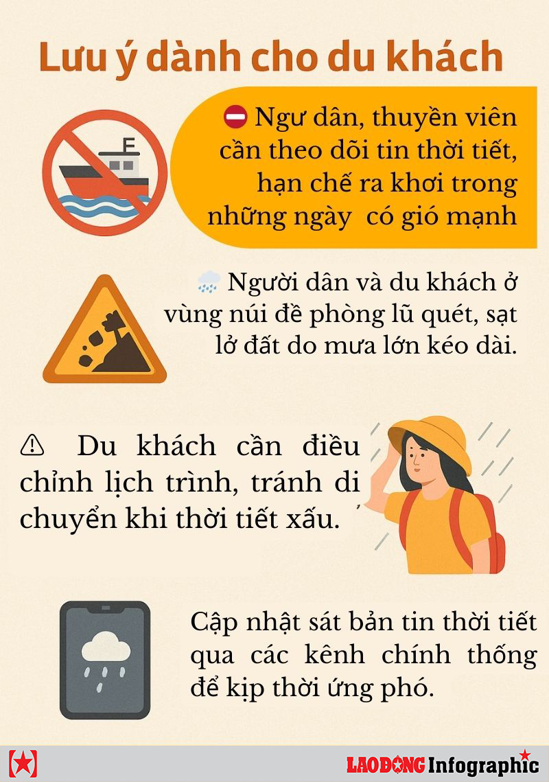
People and tourists in the Gulf of Tonkin and the sea area from Quang Tri - Quang Ngai should pay attention to weather forecasts, proactively check flight or train schedules. Follow local instructions and recommendations to ensure safety.

Khuyen cao danh cho nguoi dan va du khach. Do hoa: Ninh Phuong
Recommendations for people and tourists. Graphics: Ninh Phuong
Chí Long
TIN LIÊN QUAN

Weather forecast for today, September 11: Thunderstorms before storm No. 1 forms

|

Weather forecast for today, June 11, scattered thunderstorms across the country while the tropical depression is strengthening into a storm in the East Sea.

Storm No. 1 forecast to make landfall twice and the area will be severely affected

|

Storm No. 1 is forecast to form from the tropical depression on the afternoon of June 11, with strong winds of level 8, gusts of level 10 and continue to strengthen. The danger zone is expanding in the East Sea.

Weather forecast for tomorrow, September 11: Storm No. 1 is about to form, rain exceeds 450mm

|

Weather forecast for tomorrow, June 11, the tropical depression will strengthen into a storm. South Central, Central Highlands, and South have moderate to heavy rain, some places exceeding 150mm.

Weather forecast for today, September 11: Thunderstorms before storm No. 1 forms

Chí Long |

Weather forecast for today, June 11, scattered thunderstorms across the country while the tropical depression is strengthening into a storm in the East Sea.

Storm No. 1 forecast to make landfall twice and the area will be severely affected

Ninh Phương |

Storm No. 1 is forecast to form from the tropical depression on the afternoon of June 11, with strong winds of level 8, gusts of level 10 and continue to strengthen. The danger zone is expanding in the East Sea.

Weather forecast for tomorrow, September 11: Storm No. 1 is about to form, rain exceeds 450mm

Ninh Phương |

Weather forecast for tomorrow, June 11, the tropical depression will strengthen into a storm. South Central, Central Highlands, and South have moderate to heavy rain, some places exceeding 150mm.