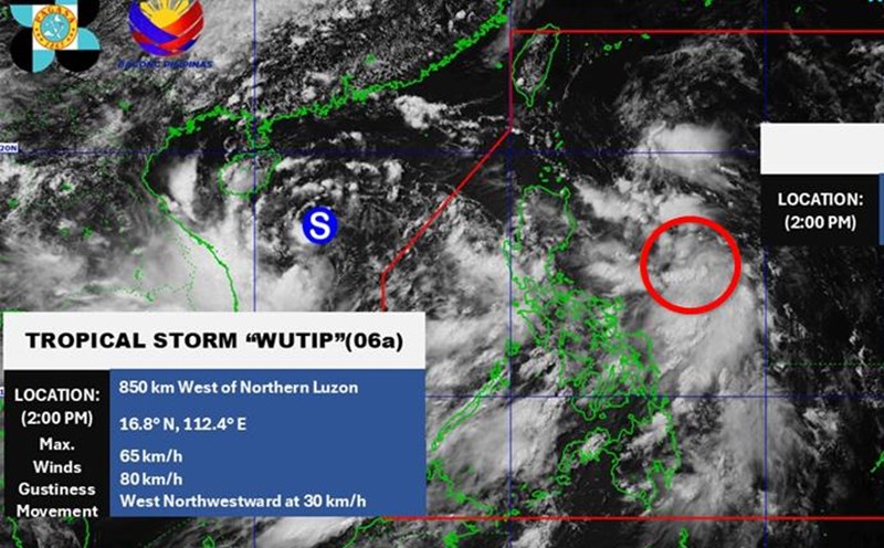
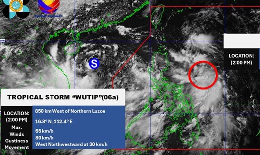
According to the National Center for Hydro-Meteorological Forecasting, at 7:00 p.m. on June 11, the center of the storm was at about 16.7 degrees North latitude - 111.4 degrees East longitude, in the Hoang Sa archipelago.
The strongest wind near the storm center is level 8 (62-74km/h), gusting to level 10; moving in the West Northwest direction at a speed of about 15km/h.
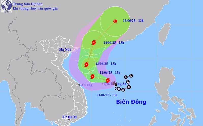
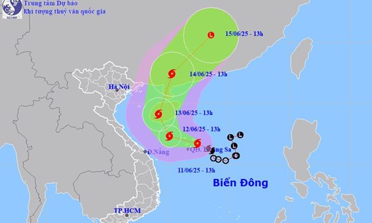
It is forecasted that by 7:00 p.m. on June 12, the storm will move in a West-Northwest direction at a speed of about 10km/h. The center of the storm is located at about 17.6 degrees North latitude - 109.7 degrees East longitude, in the sea area south of Hainan Island (China).
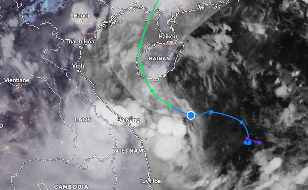
The strongest wind near the storm center is level 10, gusting to level 13. Natural disaster risk level: level 3 for the western part of the North East Sea (including Hoang Sa archipelago), the offshore waters from Quang Tri to Quang Ngai.
At 7:00 p.m. on June 13, the storm moved north-northeast at a speed of about 10km/h. The center of the storm is located at about 19.4 degrees North latitude - 109.0 degrees East longitude, in the area west of Hainan Island (China).
The strongest wind near the storm center is level 9 - 10, gusting to level 13. Natural disaster risk level: level 3 for the western part of the North East Sea, the offshore waters from Quang Tri to Quang Ngai, the waters of the Gulf of Tonkin.
It is forecasted that at 7:00 p.m. on June 14, the storm will continue to move in the North Northeast direction, with a speed of 15km/h and gradually weakening.
From the next 72 to 96 hours, the storm will move northeast at about 20km per hour, continuing to weaken.
Due to the influence of the storm, from the evening of June 11 to June 13, in the Central Central region, there will be heavy to very heavy rain with common rainfall from 100-250mm, some places over 450mm.
The Northern Central Highlands region will have moderate rain, heavy rain and thunderstorms, locally very heavy rain with common rainfall from 70- 150mm, some places over 200mm.
People and tourists in the Central Central and Central Highlands regions should pay attention to weather forecasts and proactively check flight or train schedules. Absolutely follow local instructions and recommendations to ensure safety.
At sea, the western part of the North East Sea (including the Hoang Sa archipelago) has strong winds of level 7-8, the area near the storm's eye has level 9-10, gusts of level 13, waves 3.0-5.0m high, the area near the storm's eye has 4.0-6.0m, the sea is very rough.
From the night of June 11, the offshore waters from Quang Tri to Quang Ngai will have winds gradually increasing to level 6-8, the areas near the storm's eye will have winds of level 9-10, gusts of level 13, waves 3.0-5.0m high, very rough seas.
From June 12, the sea area of the Gulf of Tonkin will have winds gradually increasing to level 6-7, near the storm center level 8-9, gusts of level 11, waves 2.0-4.0m high, very rough seas.
Ship operating in the above-mentioned dangerous areas are likely to be affected by thunderstorms, whirlwinds, strong winds, and large waves.