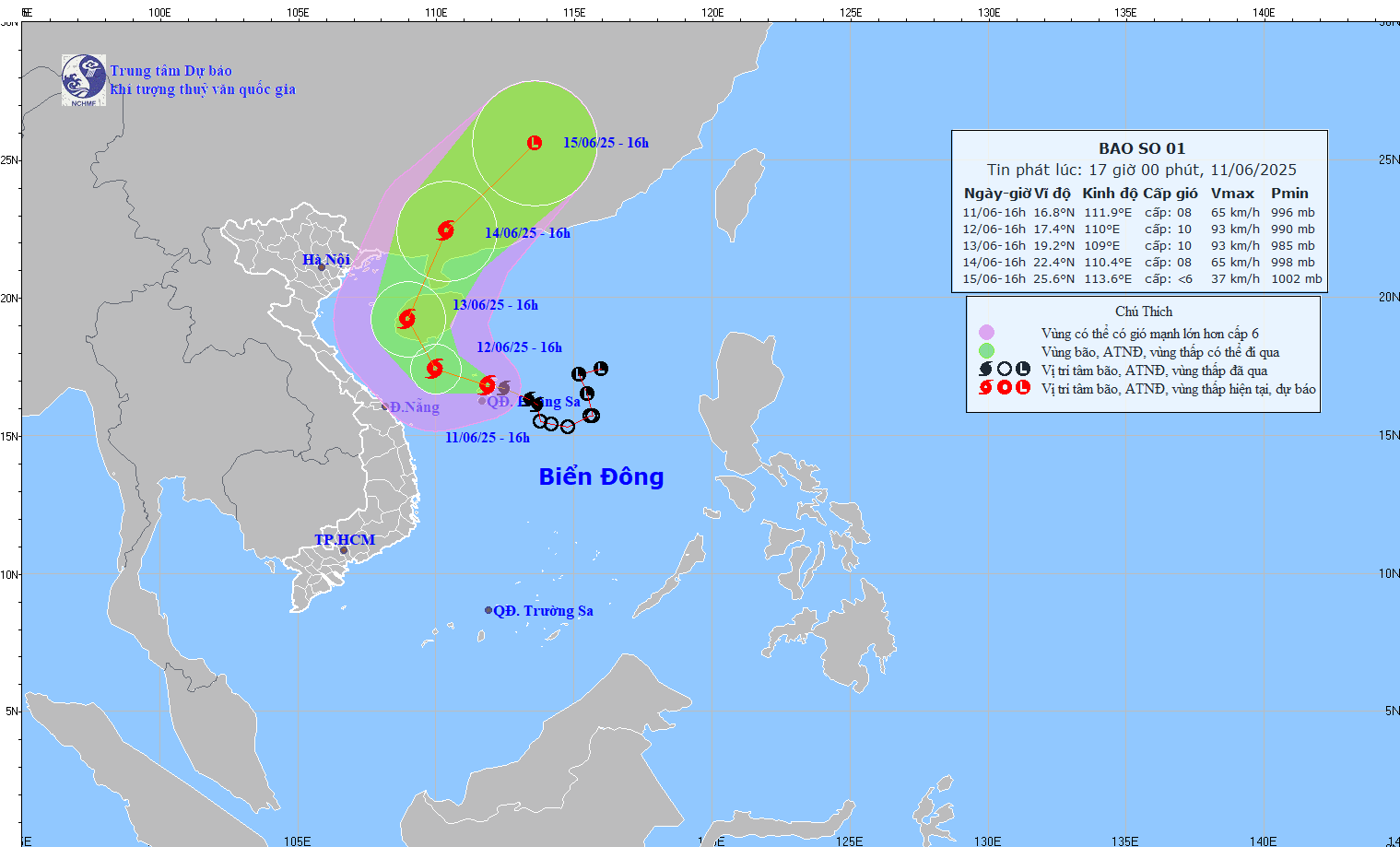
Weather forecast for tomorrow, June 12, storm No. 1 WUTIP continues to affect the weather at sea and on land in Vietnam.
Storm No. 1 is forecast to move in the West Northwest direction, at a speed of about 10-15km/h and is likely to strengthen, according to the National Center for Hydro-Meteorological Forecasting.
By the afternoon of June 12, the storm is forecast to be at about 17.4 degrees North latitude to 110.0 degrees East longitude. Intensity level 9-10, gust level 13.
From the afternoon of June 11 to June 13, the Central Central region will have heavy to very heavy rain with common rainfall from 100-250mm, some places over 450mm.
The Northern Central Highlands region will have moderate rain, heavy rain and thunderstorms, locally very heavy rain with common rainfall from 70-150mm, some places over 200mm.
Meanwhile, the North also has scattered showers and thunderstorms; the plains have scattered showers and thunderstorms.
People and tourists in affected areas should proactively monitor weather forecasts, limit going out and sea when the weather is bad and follow the instructions of local authorities.
Weather forecast for the night of June 11 and 12, 2025
Hanoi
Lowest temperature: 25-27 degrees Celsius Highest temperature: 30-32 degrees Celsius Cloudy, sometimes with showers and thunderstorms.
North to northwest wind level 2-3.During thunderstorms, beware of tornadoes, lightning and strong gusts of wind.
Northwest
Lowest temperature: 23-26 degrees Celsius, some places below 22 degrees Celsius Highest temperature: 31-34 degrees Celsius Cloudy, scattered showers and thunderstorms, sunny days.
Light wind.During thunderstorms, there is a possibility of tornadoes, lightning and strong gusts of wind.
Northeast
Lowest temperature: 24-27 degrees Celsius, mountainous areas below 24 degrees Celsius Highest temperature: 32-34 degrees Celsius; some plains have clouds, showers and thunderstorms; some plains have scattered showers and thunderstorms.
North to northwest wind level 2-3.tornado, lightning and strong gusts of wind warning during thunderstorms.
Provinces from Thanh Hoa to Hue
Lowest temperature: 24-27 degrees Celsius Highest temperature: North 30-33 degrees Celsius; South 27-29 degrees Celsius Cloudy.
The North has scattered showers and thunderstorms, locally heavy rain.In the South, there will be heavy to very heavy rain with thunderstorms.North to northwest wind level 2-3; in the South level 3-4, some places have gusts of level 6-7.Warning of tornadoes, lightning, hail and strong gusts of wind during thunderstorms.
Area from Da Nang to Binh Thuan
Lowest temperature: 24-27 degrees Celsius Highest temperature: North 27-29 degrees Celsius; South 30-33 degrees Celsius Cloudy.
In the North, there will be heavy to very heavy rain with thunderstorms.In the South, there will be scattered showers and thunderstorms, with some places having very heavy rain (rain concentrated in the late afternoon and night).West to southwest wind level 3-4, some places gust level 6-7 in the North; South level 2-3.Beware of tornadoes, lightning, hail and strong gusts of wind.
Central Highlands
Lowest temperature: 19-22 degrees Celsius Highest temperature: 23-26 degrees Celsius Cloudy, moderate rain, heavy rain and thunderstorms; some places have very heavy rain.
In the South, there will be scattered showers and thunderstorms during the day, with some places having heavy rain.Southwest wind level 3.Warning of tornadoes, lightning, hail and strong gusts of wind during thunderstorms.
Southern region
Lowest temperature: 23-26 degrees Celsius Highest temperature: 29-32 degrees Celsius Cloudy.
At night there will be moderate rain, heavy rain and thunderstorms, locally very heavy rain.During the day, there will be scattered showers and thunderstorms, with some places having heavy rain.Southwest wind level 3.During thunderstorms, beware of tornadoes, lightning, hail and strong gusts of wind.