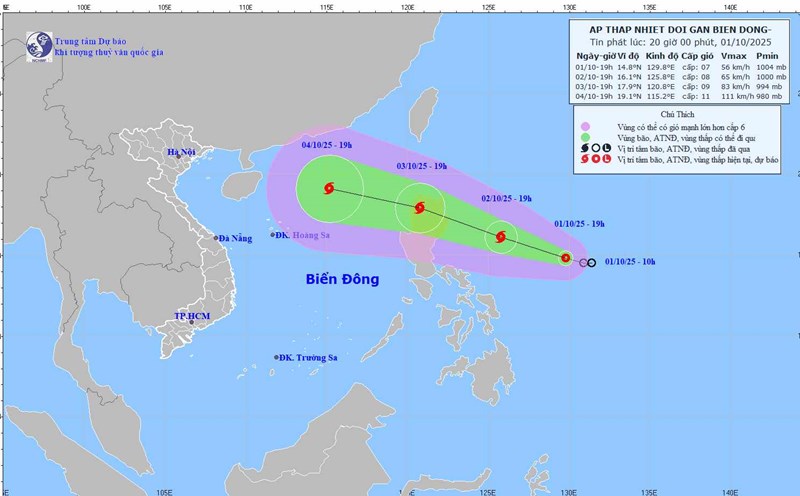
According to the latest storm news from the National Center for Hydro-Meteorological Forecasting, in the early morning of October 2, the tropical depression in the sea east of the Philippines strengthened into a storm, with the international name Matmo.
At 07:00, the center of the storm was at about 14.9 degrees North latitude and 127.8 degrees East longitude. The strongest wind near the storm center is level 8 (62-74 km/h), gusting to level 10.
The storm is moving west-northwest at a speed of 15-20 km/h.
In the next 24 to 48 hours, the storm is forecast to continue to strengthen and move in the West Northwest direction.
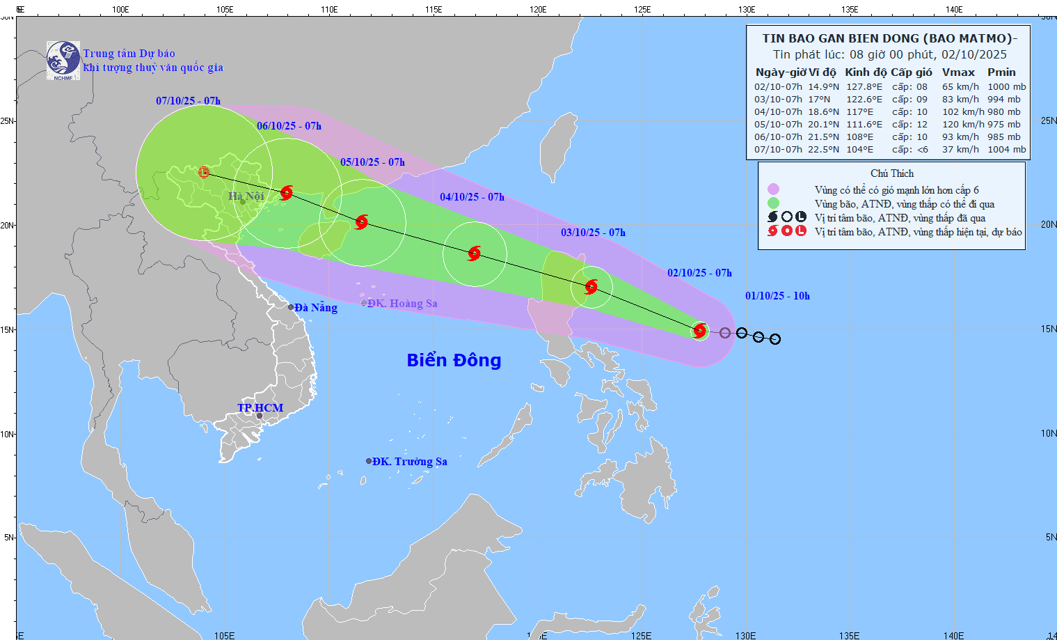
At 07:00 on October 3, the center of the storm was at about 17.0 degrees North latitude; 122.6 degrees East longitude, in the coastal area east of Luzon Island (Philippines), strong at level 9, gusting to level 11.
By the morning of October 4, the storm entered the East Sea, likely to strengthen to level 10, gusting to level 12, about 550 km east-northeast of Hoang Sa Special Zone.
The danger range is determined from latitude 16.0 scale North, east of longitude 115.0 scale East, with a natural disaster risk level of level 3 for the northeastern sea area of the East Sea.
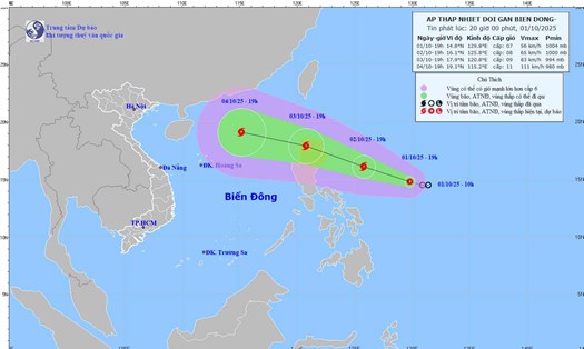
At 07:00 on October 5, the storm will continue to move in the West Northwest direction at a speed of about 25 km/h and is likely to strengthen.
The center of the storm is forecast to be at about 20.1 degrees North latitude; 111.6 degrees East longitude, in the northwest sea of the North East Sea, about 70 km northeast of Hainan Island (China).
The strongest wind near the storm center may reach level 12, gusting to level 15. The danger zone is expanding from latitude 17.0 scale North to latitude 110.0-111.0 degrees East. This area continues to maintain the level 3 natural disaster risk level.
In the next 48 to 72 hours, Typhoon Matmo is forecast to maintain its West-Northwest direction, traveling 15-20 km/h.
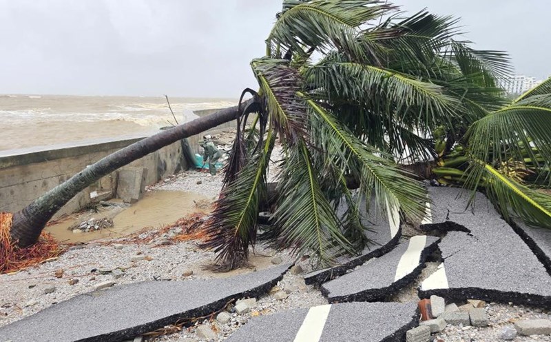
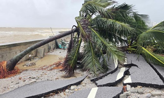
It is forecasted that from the afternoon of October 3, the impact of storm No. 11 Matmo will begin to appear. The northeastern sea area of the East Sea will have winds gradually increasing to level 6-7, then increasing to level 8. The area near the storm's eye will have strong winds of level 9-10, gusts of level 12, waves from 4.0 to 6.0 m high, very rough seas.
On October 4-5, the North East Sea area (including Hoang Sa special zone) is likely to be affected by strong winds of level 11-12, gusting to level 15.
According to the Philippine Meteorological Agency, tropical storm Matmo (local name Paolo) is about 705 km east of Quezon province (Philippines). Winds near the center of the storm are strong at 65 km/h, gusting to 80 km/h, moving west-northwest at a speed of 20 km/h.
The storm is forecast to cause heavy rain, strong gusts of wind in mountainous and coastal areas, and local flooding in the Philippines.
The risk of the storm continuing to strengthen before making landfall. Paolo is forecast to make landfall in Isabela or Aurora province on the morning of October 3 and then move to the West Philippine Sea in the afternoon of the same day.
Ships operating in the danger zone are at high risk of thunderstorms, whirlwinds, strong winds and large waves.
Tourists should limit going to sea and not travel by sea in the next 24 hours, due to rough seas and high waves.
People and tourists should proactively prevent and closely monitor the development of storm Matmo in the coming days.