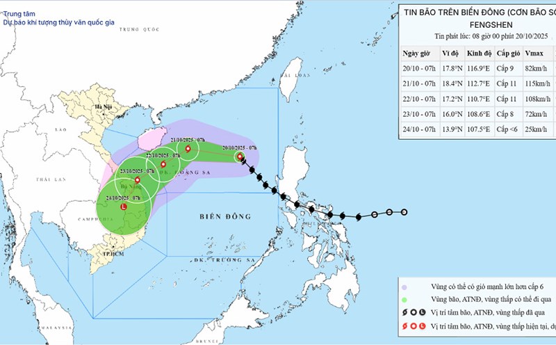
According to the latest storm news from the National Center for Hydro-Meteorological Forecasting, storm No. 12 Fengshen is currently active in the East Sea, likely to strengthen in the next 24 hours and directly affect the Central region.
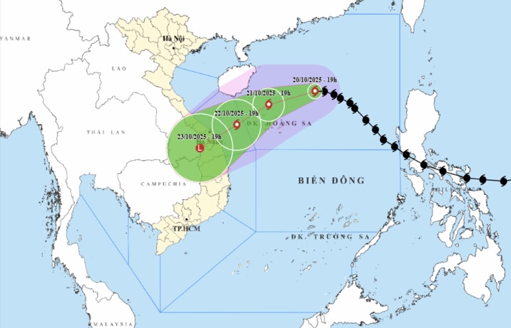
At 7:00 p.m. on October 20, the center of the storm was at about 18.5°N - 114.7°E, about 330 km East Northeast of Hoang Sa. The strongest wind is level 9-10 (75-102 km/h), gusting to level 12, moving West Northwest at about 20 km/h.
It is forecasted that by October 21, the storm will continue to move westward, then West Southwestward at a speed of 10-15 km/h, in the sea north of Hoang Sa; strong at level 11, gusting to level 13.
On the evening of October 22, the storm moved southwest, at a speed of 10 km/h, over the sea area of South Quang Tri - Quang Ngai, about 180 km east-northeast of Da Nang; weakening to level 8, gusting to level 10.
It is forecasted that by the evening of October 23, the storm will continue to move southwest at a speed of about 10-15 km/h, entering the border area of Da Nang - Quang Ngai and Southern Laos; weakening into a tropical depression, then a low pressure area (under level6).
Natural disaster risk level 3, the North East Sea area (including Hoang Sa) and the sea area from South Quang Tri to Quang Ngai (including Ly Son).
.
The sea area of South Quang Tri - Quang Ngai (including Ly Son) has winds of level 6, increasing to level 7, near the storm center level 8-9, gusting to level 11. Waves 3.0-5.0 m high, very rough seas.
All vessels operating in this area are advised to urgently move out of the danger zone, complying with the instructions of the authorities to ensure safety.
On land, from the night of October 22 to October 26, due to the influence of the storm circulation combined with cold air and East wind, the area from Ha Tinh to Quang Ngai is likely to experience widespread heavy rain.
Ha Tinh to Bac Quang Tri and Quang Ngai: total rainfall is generally 200 - 400mm, some places over 500mm.
It is forecasted that South Quang Tri to Da Nang will have common rainfall of 500-700mm, some places exceeding 900mm.
Heavy rain may last until the end of October 2025, with the risk of flash floods, landslides, and flooding in low-lying areas and urban areas.
Prolonged heavy rain is at risk of causing flash floods, landslides in mountainous areas and flooding in low-lying areas and urban areas.
Hydropower and irrigation reservoirs need to be operated safely, ready to respond to the possibility of flooding to alert level 3 or higher in rivers from Quang Tri to Quang Ngai.
The risk level of natural disasters due to floods and inundation is determined to be level 3.
The authorities recommend that fishermen and fishing vessels closely monitor weather information and proactively take shelter.
Tourists in the Central coastal provinces should limit going to sea, temporarily postpone sea tourism and mountain climbing activities from October 22 to 26.
People in mountainous areas need to proactively evacuate from areas at risk of landslides and flash floods; at the same time, store necessities, fully charge communication devices, and closely monitor the next bulletins.