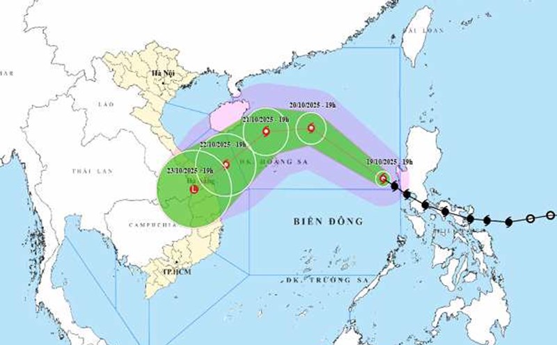
According to the latest storm information from the National Center for Hydro-Meteorological Forecasting (NCHMF), on the morning of October 20, storm No. 12 Fengshen was at about 17.8 degrees North latitude; 116.9 degrees East longitude, about 490 km East Northeast of Hoang Sa Special Zone.
The strongest wind near the storm center is level 9 (75-88 km/h), gusting to level 11. The storm is moving northwest at a speed of about 25 km/h.
In the next 24 to 72 hours, storm No. 12 is forecast to continue moving in the West Northwest and Southwest direction with the potential to strengthen before gradually weakening.
On October 21, storm No. 12 Fengshen will move west-northwest at a speed of about 20 km/h, located at about 18.4 degrees North latitude - 112.7 degrees East longitude, about 180 km north of Hoang Sa Special Zone. The storm intensity is likely to increase to level 11, gusting to level 13.
On October 22, NCHMF forecasted that the storm will move southwest at a speed of about 10 km/h, located at about 17.2 degrees North latitude - 110.7 degrees East longitude, in the northwest sea of the Hoang Sa special zone. The intensity is maintained at level 10-11, gusting to level 13.
Level 3 natural disaster risk, affecting the western sea area of the North East Sea (including Hoang Sa special zone) and the sea area from Hue city to Quang Ngai.
Forecast on October 23, storm No. 12 will continue to move southwest at a speed of about 10 km/h, located at about 16.0 degrees North latitude - 108.6 degrees East longitude, on the coastal area from Hue City to Quang Ngai. The intensity is likely to weaken to level 8, gusting to level 10.
Meanwhile, the Joint Typhoon Warning Center (JTWC) forecasts that Typhoon Fengshen is located about 920 km east-northeast of Da Nang and will move northwest at a speed of about 19 km/h in the past 6 hours.
It is forecasted that by the evening of October 21, the storm will become a typhoon with the strongest winds near the center of about 120km/h when approaching Hainan Island (China).
At sea, the North East Sea area (including Hoang Sa special zone) has strong winds of level 7-8; the area near the storm's eye has strong winds of level 9-11, gusting to level 13. Waves from 3.0-5.0 m high, near the center of the storm 5.0-7.0 m high; rough seas. All ships and boats operating in the danger zone are at risk of being affected by thunderstorms, whirlwinds, strong winds and large waves.
Due to the influence of storm circulation and cold air combined with East wind disturbances and terrain effects, from about October 22 to 27, the area from Ha Tinh to Quang Ngai is likely to have widespread heavy rain, lasting for many days, locally very heavy rain, high risk of flash floods and landslides in mountainous areas, flooding in low-lying areas and urban areas.
Localities need to pay attention to safe operation of hydroelectric and irrigation reservoirs before, during and after the storm, and prepare response plans for flood scenarios on rivers from Quang Tri to Quang Ngai that are likely to reach alert level 3 and exceed alert level 3.
Tourists planning to travel or travel by sea in the coming days should pay special attention to closely monitoring weather forecasts and instructions from authorities.
Do not go out to sea or participate in tourism activities at sea and islands in the Central region when the storm is still active to ensure safety.