Storm No. 12 Fengshen officially enters the East Sea, accelerates towards the Central region

Chí Long |

Typhoon Fengshen officially entered the East Sea and became the 12th storm of 2025.

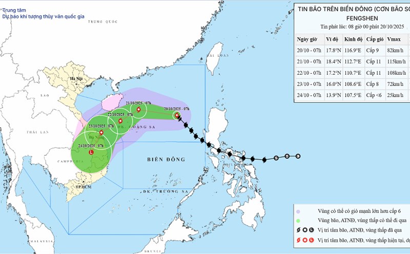
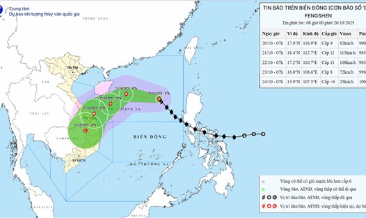
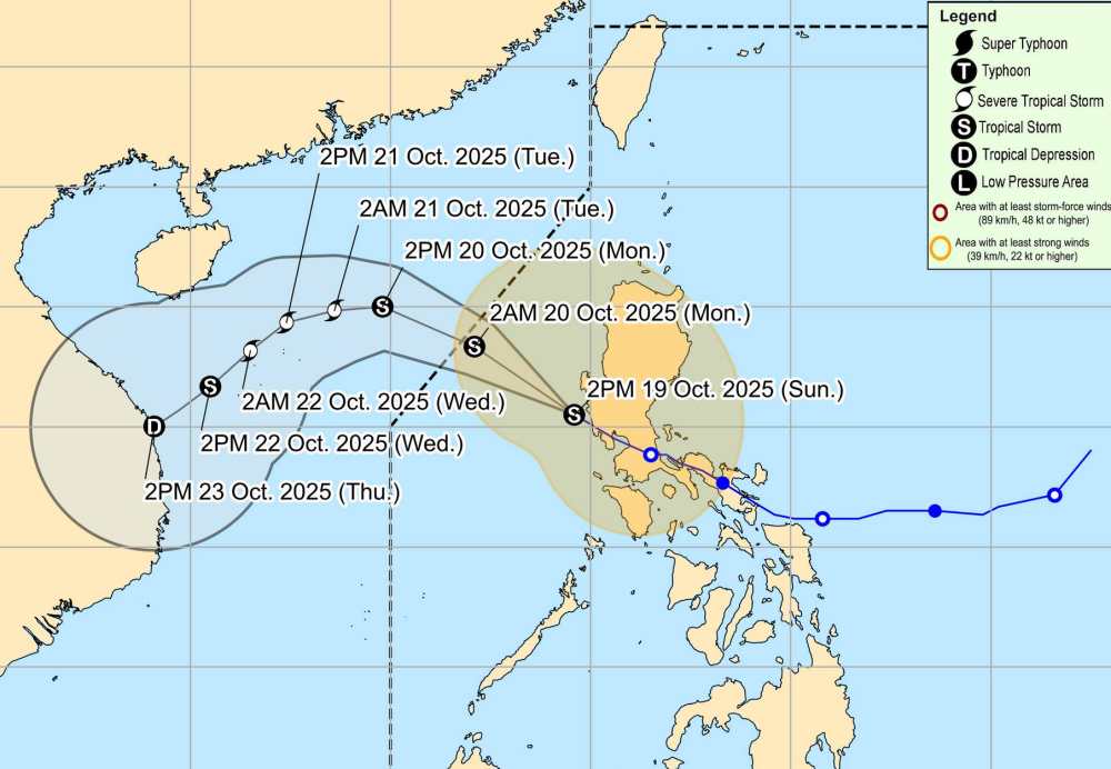
According to the latest storm news from the National Center for Hydro-Meteorological Forecasting, on the afternoon of October 19, storm No. 12 FENGSHEN was in the eastern sea of the North East Sea.

At 4:00 p.m., the center of the storm was at about 15.2 degrees North latitude - 119.7 degrees East longitude. The strongest wind near the storm center is level 9 (75-88 km/h), gusting to level 11. The storm is moving northwest at a speed of about 20-25 km/h.

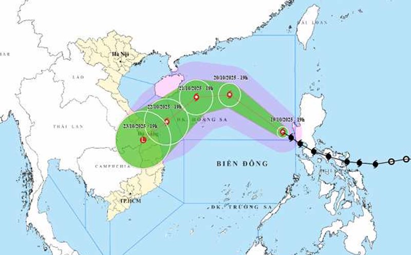
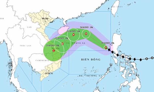
It is forecasted that by 4:00 p.m. on October 20, the storm will move northwest at a speed of 20-25 km/h. The center of the storm is located in the North East Sea, about 380 km East Northeast of Hoang Sa. The strongest wind near the storm center is level 10, gusting to level 12.

By 4:00 p.m. on October 21, the storm moved west at a speed of 10-15 km/h, about 200 km north of Hoang Sa. Strong wind level 11, gust level 13.

The Philippine Atmospheric, Geophysical and Astronomical Services Administration (PAGASA) forecasts that Typhoon Fengshen will continue to rapidly strengthen. The storm is forecast to strengthen into a severe tropical storm in the early morning of October 21.

Cap nhat huong di cua bao Fengshen tren bien. Anh: PAGASA
Update the path of storm Fengshen at sea. Photo: PAGASA

On the afternoon of October 19, the sea area from South Quang Tri to Quang Ngai, the eastern sea area of the North and Central East Sea is experiencing scattered showers and thunderstorms.

It is forecasted that the North East Sea area (including Hoang Sa special zone) will have strong winds of level 6, gusting to level 7-8; in the East, this area will have strong winds of level 6-7, near the storm center, strong winds of level 8-10, gusting to level 12. The sea is very rough. The main wind direction is the Northeast, while the East blows in many directions. The waves will be from 2.0 to 6.0 meters high, in the direction of the Northeast wave, and in the East in many directions.

Early in the morning and on October 20, in the Gulf of Tonkin, the wind gradually increased to level 6, gusting to level 7-8; rough seas. Northeast wind direction, waves from 2.0 to 4.0 meters high, Northeast waves.

In addition, on the night of October 19 and 20, the sea area from South Quang Tri to Quang Ngai, the sea area from Ca Mau to An Giang, the Gulf of Thailand, the North and Central East Sea (including the special area of Hoang Sa) will continue to have scattered showers and thunderstorms.

During thunderstorms, there is a possibility of tornadoes, strong gusts of wind of level 6-7 and waves over 2.0 meters high.

In particular, the eastern sea area of the North East Sea will have storms and rain.

People and tourists planning to visit these coastal areas should pay attention to weather forecasts. Tuan follows local instructions to avoid dangerous storms.

Chí Long
TIN LIÊN QUAN

Provinces become heavy rain due to storm No. 12, some places over 250 mm

|

The circulation of storm No. 12 combined with cold air from the North is forecast to cause heavy rain in many areas.

How does Hanoi's weather change due to stronger cold air

|

Hanoi weather forecast to cool down in the coming days due to the influence of a strong cold front.

Heavy rain due to strong cold air combined with storm No. 12

|

Cold air affects the weather in the North. Storm No. 12 causes strong winds in the North East Sea area. Nghe An to Quang Ngai will have rain, some places will have heavy rain.

Storm No. 12 Fengshen goes around the East Sea, forecast to be strong at typhoon level

|

Storm No. 12 Fengshen will change direction in the East Sea due to the influence of the stronger cold air.

Weather forecast for today, October 20: Storm No. 12 strengthens in the East Sea

|

Weather forecast for today, October 20, storm No. 12 will strengthen in the East Sea, while cold air will cause the temperature in the North to drop sharply.

Cold air strengthens, the coldest in the North is below 16 degrees Celsius

|

The cold air mass is forecast to enter the northern border area of our country, the temperature in the North will drop sharply.

Provinces become heavy rain due to storm No. 12, some places over 250 mm

Chí Long |

The circulation of storm No. 12 combined with cold air from the North is forecast to cause heavy rain in many areas.

How does Hanoi's weather change due to stronger cold air

Chí Long |

Hanoi weather forecast to cool down in the coming days due to the influence of a strong cold front.

Heavy rain due to strong cold air combined with storm No. 12

Chí Long |

Cold air affects the weather in the North. Storm No. 12 causes strong winds in the North East Sea area. Nghe An to Quang Ngai will have rain, some places will have heavy rain.

Storm No. 12 Fengshen goes around the East Sea, forecast to be strong at typhoon level

Ninh Phương |

Storm No. 12 Fengshen will change direction in the East Sea due to the influence of the stronger cold air.

Weather forecast for today, October 20: Storm No. 12 strengthens in the East Sea

Chí Long |

Weather forecast for today, October 20, storm No. 12 will strengthen in the East Sea, while cold air will cause the temperature in the North to drop sharply.

Cold air strengthens, the coldest in the North is below 16 degrees Celsius

Chí Long |

The cold air mass is forecast to enter the northern border area of our country, the temperature in the North will drop sharply.