According to the latest storm news from the National Center for Hydro-Meteorological Forecasting, at 7:00 p.m.today, November 25, the center of the storm was at about 10.9 degrees North latitude - 120.4 degrees East longitude, in the western sea of the central Philippines.The strongest wind near the storm center is level 8 (62-74km/h), gusting to level 10.
The storm is moving west-northwest at a speed of 20-25km/h.It is forecasted that by 7:00 p.m.on November 26, the storm will move in a West-Northwest direction at a speed of 20-25 km/h, entering the East Sea.The center of the storm is located at about 12.7 degrees North latitude - 115.8 degrees East longitude, in the eastern sea area of the Central East Sea.The storm is likely to strengthen.
The strongest wind near the storm center is level 9, gusting to level 11. Natural disaster risk level: level 3 for the eastern sea area of the Central East Sea (including the northeastern sea area of Truong Sa).
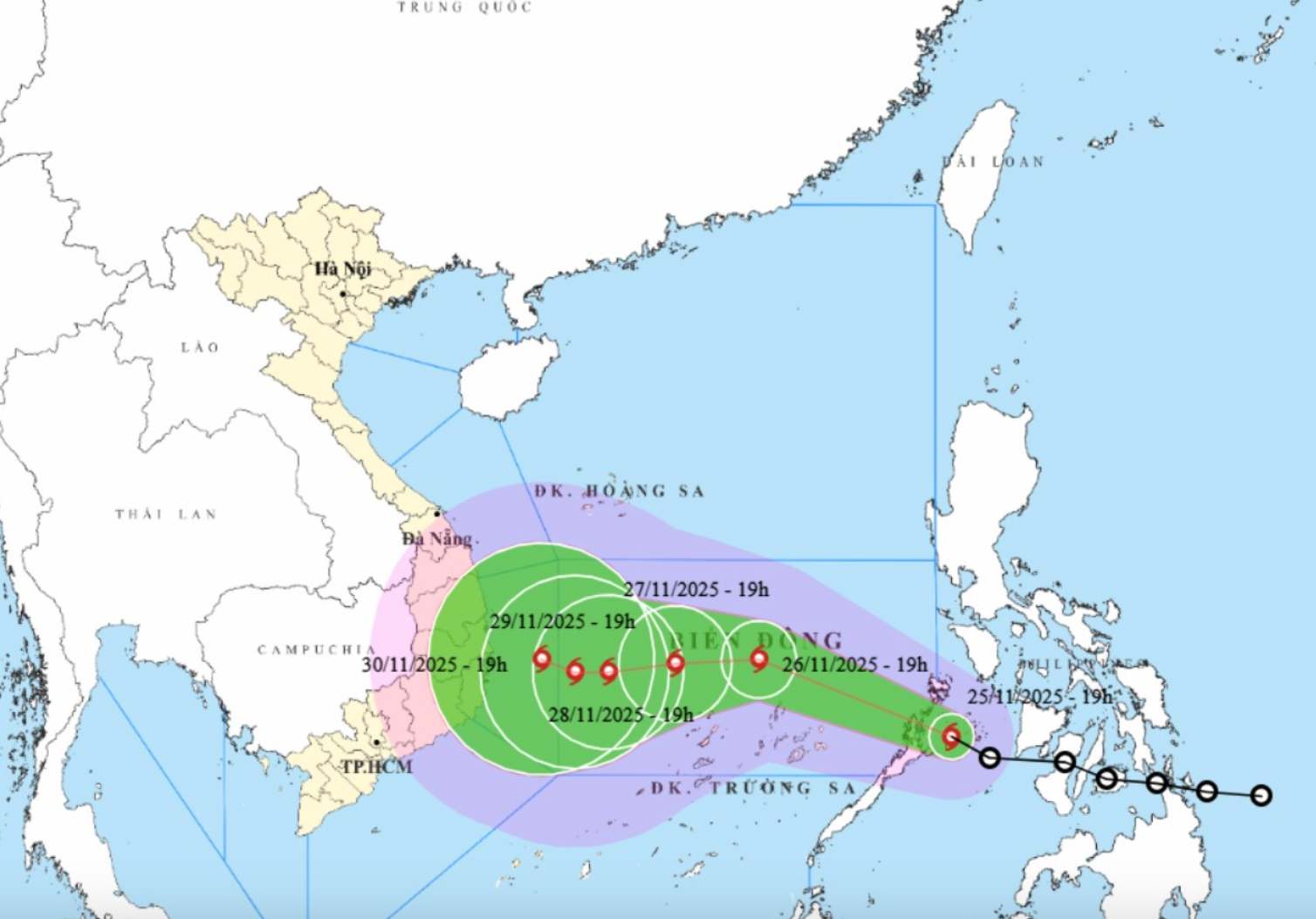
At 7:00 p.m. on November 27, the storm moved west at a speed of 5-10km/h. The center of the storm is located at about 12.6 degrees North latitude - 113.8 degrees East longitude, in the Central East Sea. The storm is forecast to strengthen.
The strongest wind near the storm center is level 10-11, gusting to level 13. Natural disaster risk level: level 3 for the Central East Sea area (including the sea area north of Truong Sa special zone).
At 7:00 p.m. on November 28, the storm moved west at a speed of 5-10km/h. The center of the storm is located at about 12.4 degrees North latitude - 112.2 degrees East longitude, in the western sea area of the Central East Sea. The storm is likely to continue to strengthen.
The strongest wind near the storm center is level 11, gusting to level 13. Natural disaster risk level: level 3 for the Central East Sea area (including the sea area north of Truong Sa special zone).
From the next 72 to 120 hours, the storm will move slowly in the West direction, then turn West Northwest with little change in intensity, then gradually weaken.
Due to the influence of the storm, the sea area east of the Central East Sea will have winds gradually increasing to level 6-7; The area near the center of the storm will have strong winds of level 8-9, gusts of level 11, waves 4.0-6.0m high, very rough seas.
During the period of November 27-28, the Central East Sea area (including the northern sea area of Truong Sa special zone) is likely to be affected by strong winds of level 10-11, gusts of level 14, waves 7.0 9.0m high, and rough seas.
Ship operating in the above-mentioned dangerous areas are likely to be affected by thunderstorms, whirlwinds, strong winds, and large waves.
People and tourists coming to these coastal areas should pay attention to weather forecasts. Tuan follows local instructions and does not go to sea when the sea is rough to avoid dangerous storms.


