Tropical depression - remnant of storm Senyar - officially enters the East Sea
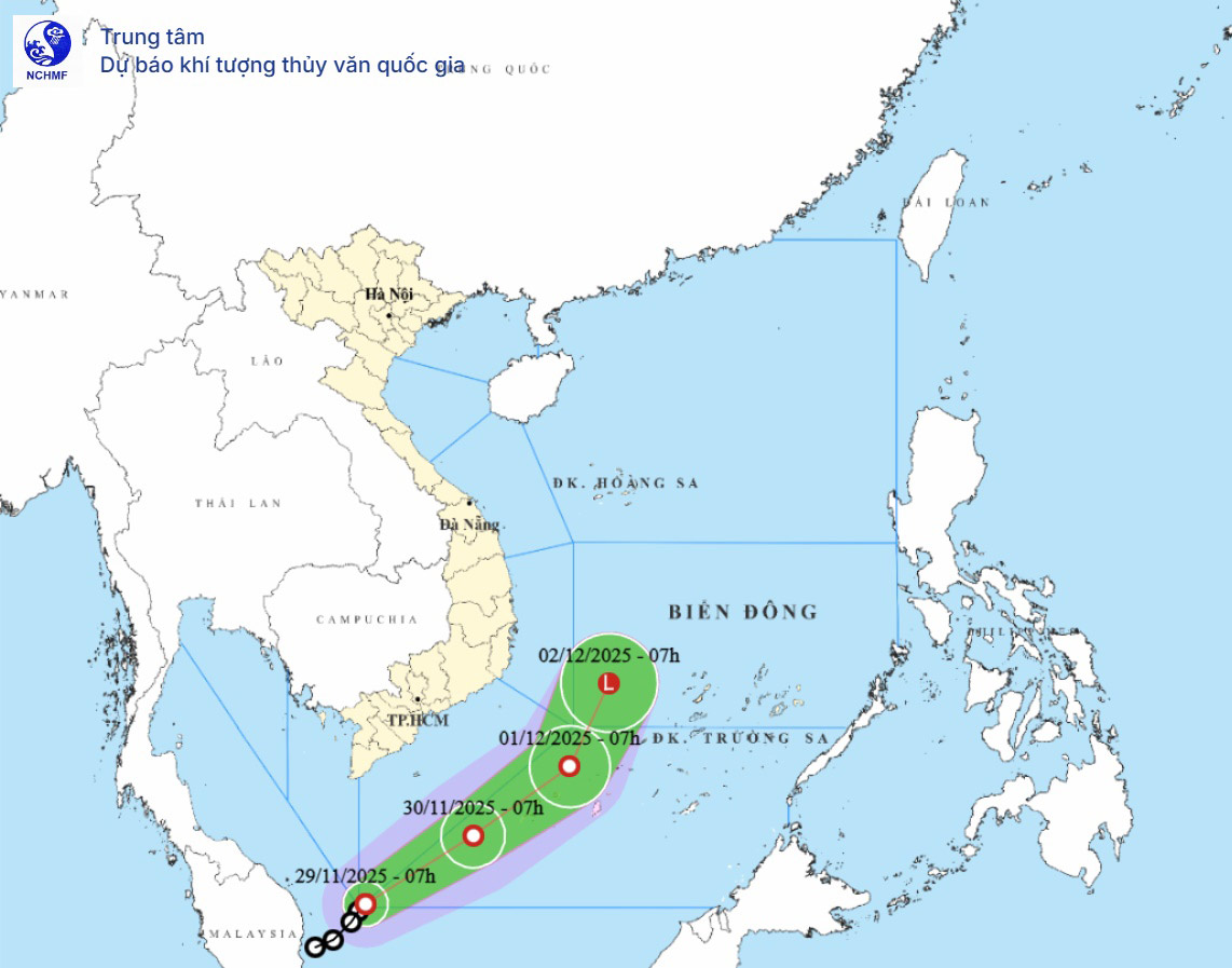
On November 29, the center of the tropical depression was at about 5.1 degrees North latitude; 105.2 degrees East longitude, in the southwestern sea area of the South China Sea. The strongest wind near the center is level 6-7, gusting to level 9, moving in the North Northeast direction at a speed of 10-15km/h.
This is the remnant of Typhoon Senyar - moving from the Indian Ocean to the Pacific Ocean. This is the first tropical depression from the equatorial coordinates in the Malacca Strait to move back up to the East Sea in 2025 - an unusual path.
Typhoon Senyar suddenly appeared on the night of November 25-26 and made landfall in Indonesia on the morning of November 26 with sustained winds of 70-80 km/h, gusting to 90 km/h.This is an extremely rare storm, because there are almost no storms forming in the Malacca Strait or making landfall in Indonesia in the North Indian Ocean.Since 1842, more than 180 years have not seen any strong tropical cyclones recorded at the Senyar site.
In the next 24-48 hours, the tropical depression will continue to move in the East Northeast direction and then Northeast at a speed of about 15km/h.
From the next 48 to 72 hours, the tropical depression will continue to move in the North Northeast direction at a speed of 10-15km/h and gradually weaken into a low pressure area.
By the morning of November 30, the center of the tropical depression was at 7 degrees North latitude; 108.2 degrees East longitude, maintaining the intensity of level 7, gusting to level 9.
At 01.12, the tropical depression began to weaken to level 6, gusting to level 8 as it moved northwest of the South China Sea.
The danger zone is expanding to the south of the latitude of 10.5 degrees North latitude and to the west of the latitude of 112 degrees East longitude; the natural disaster risk level is level 3 for the southwestern and western seas of the South China Sea.

Storm No. 15 Koto mongers in the East Sea
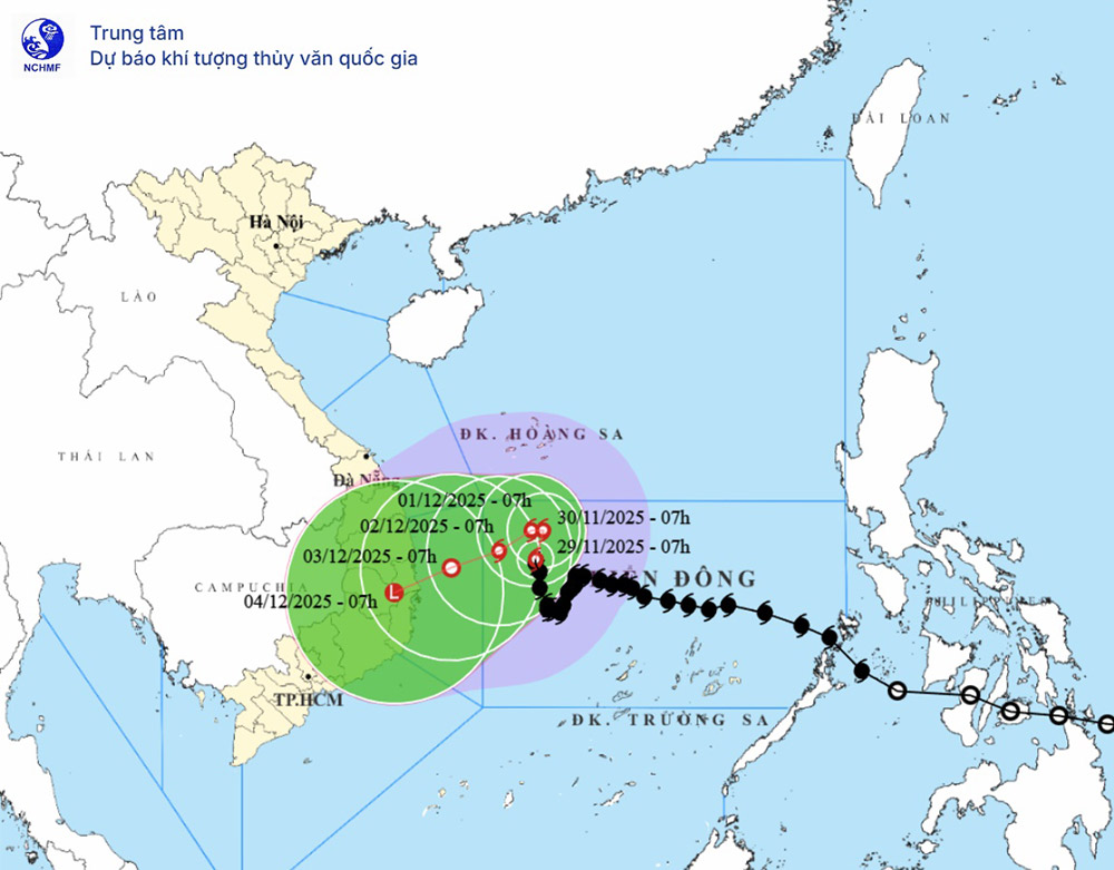
Meanwhile, the center of storm No. 15 (storm Koto) is at about 13.6 degrees North latitude; 112.3 degrees East longitude, about 320km northwest of Song Tu Tay Island.
The strongest wind near the storm center is level 9-10, gusting to level 13, moving north at a speed of about 5km/h.
This is the latest development of storms active in the East Sea and continues to cause danger in the central sea area.
It is forecasted that in the next 24-72 hours, storm No. 15 will move mainly north, then change direction to the West and Southwest at a speed of 2-5km/h.
By November 30, the storm center was at 14.3 degrees North latitude; 112.5 degrees East longitude, in the northwest sea of the Central East Sea, maintaining the intensity of level 9-10, gusting to level 13.

On December 1, storm Koto began to weaken, reaching level 9, gusting to level 12 when it was near a location about 310km from the East coast of Gia Lai - Dak Lak. By December 2, the storm will continue to weaken to level 8-9, gusting to level 12 as it moves slowly towards the Southwest.
During this period, the dangerous area in the East Sea will expand from 11.5-15.5 degrees North latitude and west of 114 degrees East longitude, with a level 3 natural disaster risk for the Northwest Central East Sea and the offshore waters from Gia Lai to Khanh Hoa.
From the next 72 to 120 hours, a new storm is forecast. most shows that storm Koto continues to move very slowly in the West Southwest direction at a speed of about 5km/h and weakens further.
At sea, strong winds and large waves continue to be the main risks. The Northwest area of the Central East Sea will have strong winds of level 7-8, near the center of the storm will have strong winds of level 9-10, gusts of level 12-13; waves 3-5m high, near the center of the storm 6-8m, very rough seas.
The offshore sea area from Gia Lai to Khanh Hoa will have winds gradually increasing to level 6-7, then increasing to level 8, gusting to level 9-10, waves 4-6m high. Ship in the danger zone are at high risk of being affected by thunderstorms, whirlwinds and large waves due to the impact of storm No. 15 Koto.
At sea, the southwest and southwest of the East Sea will have winds gradually increasing to level 6-7, gusting to level 9; waves 2.5-4m high, rough seas. Ships in the area need to pay attention to be on guard against thunderstorms, whirlwinds, strong winds and large waves due to the impact of the tropical depression.
Tourists planning to travel by boat, canoe or participate in sea tours, diving, fishing, coral viewing... in the areas from the central to southern East Sea should closely monitor the latest storm news, especially storm No. 15 (storm Koto) and tropical depression.
Many localities in the Central and South have banned the sea, requested ships to take shelter from the storm and prepared evacuation and relocation plans.


