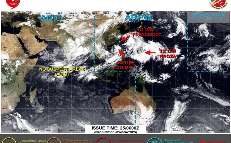
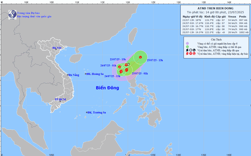
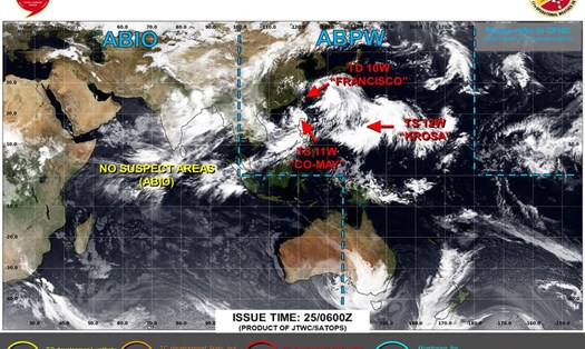
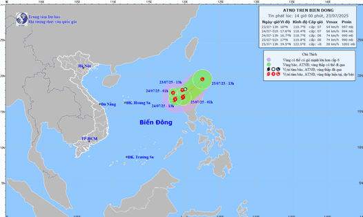
According to the latest typhoon forecast from the Joint Typhoon Warning Center (JTWC), on the morning of July 27, tropical depression Co-may was located about 51 km northwest of Kadena, Okinawa Island, Japan, moving slowly in an east-southeast direction at a speed of about 10 km/h, with sustained winds near the center of 56 km/h, gusting 74 km/h. The highest recorded waves were 4 meters.
The predecessor of this tropical depression is Typhoon Co-may, named Emong in the Philippines, the 8th typhoon in Japan. This is the 4th storm in the East Sea in the 2025 storm season, also known as Typhoon Co May in Vietnam.
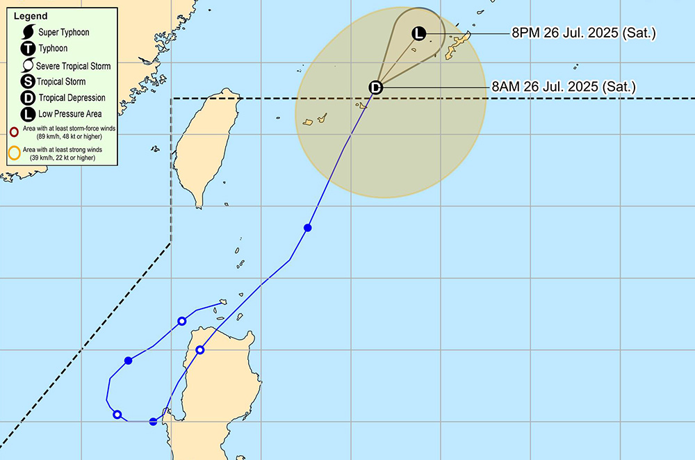
Although Co-may is unlikely to return to the South China Sea, its remnants are forecast to continue operating in the north-northeast of Okinawa Island, Japan for at least the next day, at tropical depression strength.
It is forecasted that in the next 12 hours, this tropical depression will continue to move slowly to the east-northeast to the north, before turning strongly to the west-northwest.
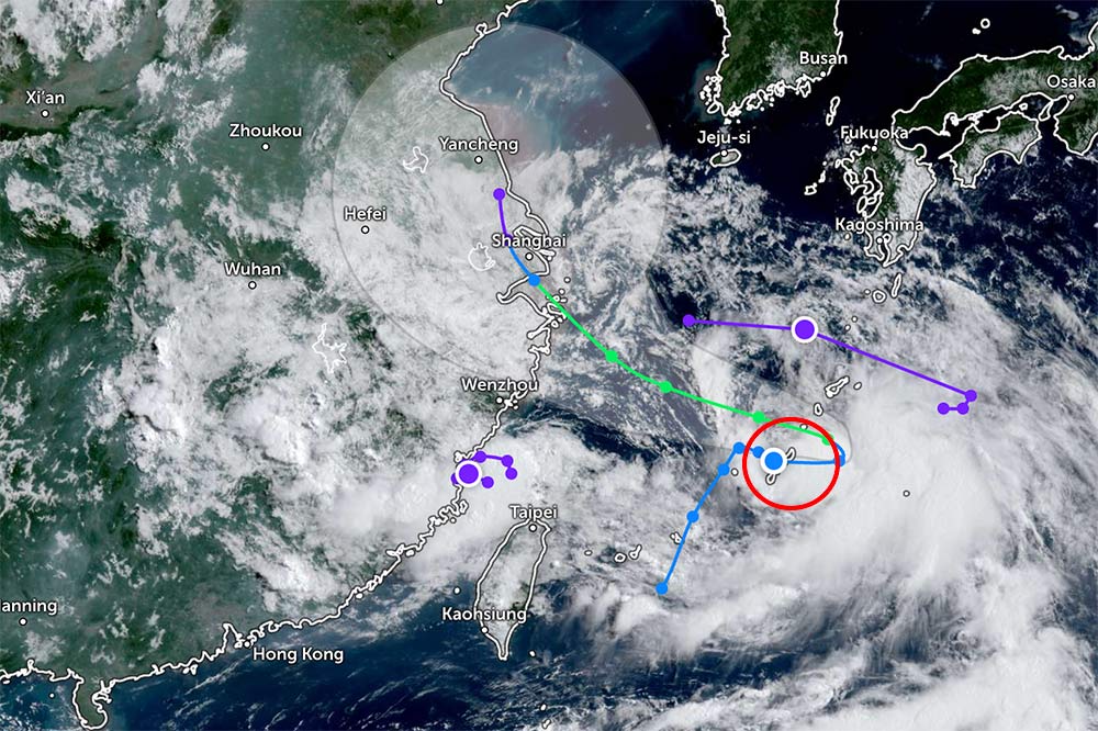
The tropical depression could then recover very quickly, strengthen back into a tropical storm, moving faster northwest toward China's east coast.
Co-may is expected to make landfall late Tuesday, July 29 or early Wednesday morning, July 30. The storm is forecast to make landfall in the southern part of Shanghai, reaching a maximum intensity of about 85 km/h within the next 60 hours.
High-reliability intensity forecast models suggest that Co-may could reach maximum wind speeds of 65-95 km/h over the next 1.5 to 3 days.
After making landfall, Co-may will move northward over land, gradually weakening and dissipating.
Tourists in Vietnam's coastal and island areas need to pay attention to weather forecasts. On July 27, in the North and Central East Sea (including Hoang Sa special zone) and the sea area of Ca Mau - An Giang, there will be scattered showers and thunderstorms in some places. The southwest wind in Phu Quy special zone is strong at level 6.
Sea weather forecast for the night of July 27 and July 28, the eastern sea area of the North East Sea, the central East Sea and the sea area from Gia Lai to Ho Chi Minh City: strong southwest winds of level 6, gusting to level 7-8; rough seas; waves 2.0-4.0m high.
The North and Central East Sea area (including Hoang Sa special zone), the sea area from Lam Dong to Ca Mau, from Ca Mau to An Giang and the Gulf of Thailand will have scattered showers and thunderstorms.
Weather forecast for the night of July 28 and July 29, the North and Central East Sea will have strong southwest winds of level 6, sometimes level 7, gusting to level 8-9; waves 2.0-4.5m high; rough seas.
The sea area from Gia Lai to Ho Chi Minh City will have strong southwest winds of level 6, gusting to level 7-8; waves 2.0-4.0m high; rough seas. Danger to ships due to tornadoes, strong winds and big waves.
From Tuesday evening, July 29 to Wednesday morning, July 30, the weather forecast is strong winds, heavy rain, flash floods and localized flooding in the Shanghai region and neighboring provinces in eastern China. Tourists should not travel to coastal areas or mountainous areas at this time.
Tourist boats, high-speed boats and ferries may temporarily suspend operations. It is necessary to closely monitor notices from local authorities or seaport management agencies.
Travelers should contact the airline in advance to update flight information if they plan to visit Okinawa (Japan); Shanghai and Taiwan (China).