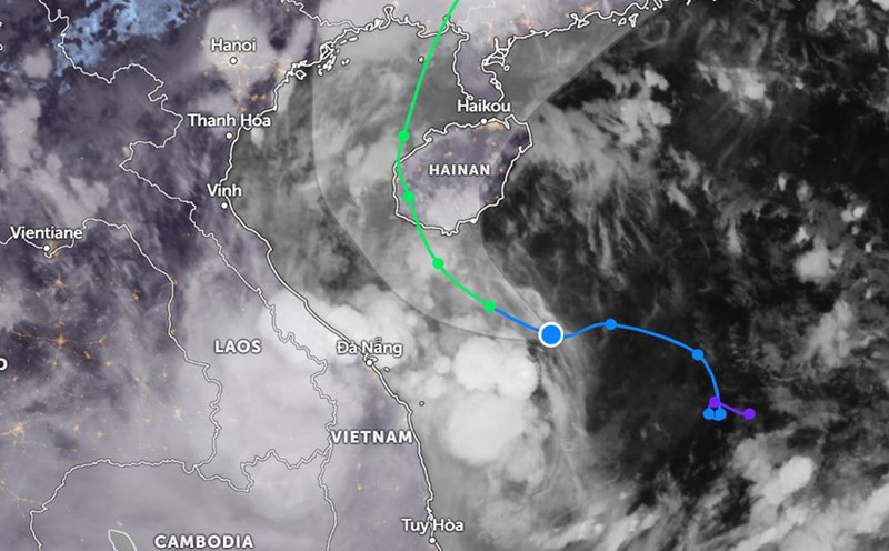
According to new storm news from the National Center for Hydro-Meteorological Forecasting, at 4:00 a.m. on June 12, the center of the storm was at about 16.7 degrees North latitude - 110.7 degrees East longitude, in the western area of Hoang Sa archipelago.
The strongest wind near the storm center is level 8-9 (62-88km/h), gusting to level 11. The storm is moving west-northwest at a speed of 10-15km/h.
By 1:00 p.m. on June 12, the center of storm No. 1 will be in the area south of Hainan Island (China) with strong winds of about level 9, gusting to level 11.
After this time, storm No. 1 has two moving scenarios, according to the National Center for Hydro-Meteorological Forecasting.
In the scenario considered highly likely, storm No. 1 will reach strong winds of up to level 10, gusting to level 13 when entering Hainan Island, then turning north to northeast, towards Lusian Peninsula and then entering mainland China.
With this scenario, the western area of the North East Sea (including Hoang Sa archipelago) as well as the northern part of the central East Sea will have thunderstorms, strong winds from level 6-7, at the center of the storm, winds up to level 8-9, gusts up to 11, waves 3-5m high, and rough seas. The intensity of storm No. 1 can reach level 10, gusting to 12.
The coastal areas from Quang Ninh to Quang Nam (including Co To, Hon Ngu) will have strong winds from level 5-6, gusting up to 7.
In the remaining scenario, when Typhoon No. 1 approaches Hainan Island (China), it will turn to the west of the island, after entering the eastern part of the Gulf of Tonkin, the storm will turn north, into mainland China.
With this scenario, the Gulf of Tonkin will have strong winds up to level 8-9, gusting to 11-12. The impact of storm No. 1 on the northern coastal waters will be stronger and more dangerous.

Due to the influence of storm No. 1, the Central Central and Northern Central Highlands regions have had heavy to very heavy rain. From 7:00 p.m. on June 11 to 3:00 a.m. on June 12, heavy rain occurred in Bach Ma (Hue): 366.8mm; Hoa Hiep Bac (Da Nang): 333.8mm; Tan Hiep (Quang Nam): 240.2mm; Heavy to very heavy rain in the Central Central region; Central Highlands has some places with very heavy rain and thunderstorms.
Weather forecast from June 12 to June 13, the Central Central region will have heavy to very heavy rain, with common rainfall from 100-200mm, some places over 350mm. Ha Tinh and the Northern Central Highlands will have moderate rain, heavy rain and thunderstorms; locally very heavy rain with common rainfall from 30-80mm, some places over 150mm. There is a risk of heavy rain over 200mm in 6 hours.
People and tourists need to be on guard against the risk of flash floods, landslides, and land subsidence on steep slopes and small streams in the provinces of Ha Tinh, Quang Binh, Quang Tri, Hue City, Da Nang, Quang Nam, Quang Ngai, and Kon Tum.