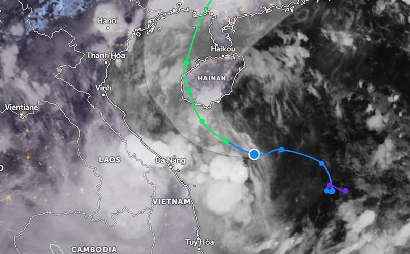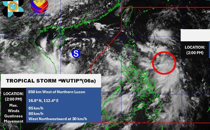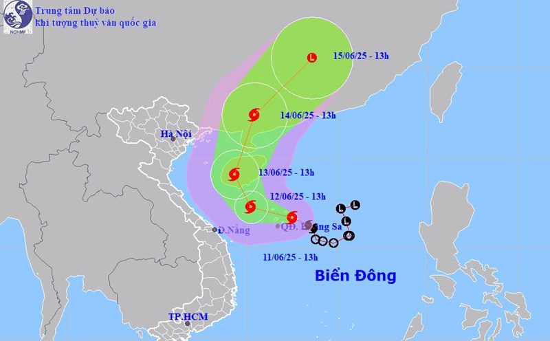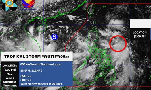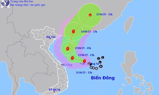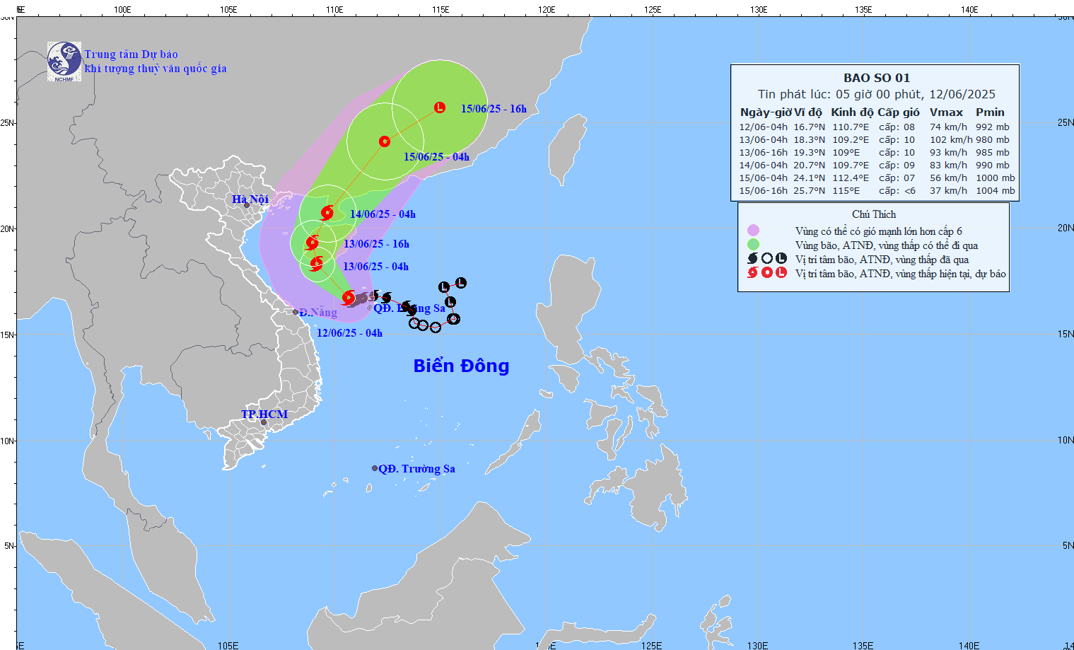
According to the latest storm news from the National Center for Hydro-Meteorological Forecasting, at 4:00 a.m. on June 12, the center of storm No. 1 WUTIP was at about 16.7 degrees North latitude - 110.7 degrees East longitude, in the western area of Hoang Sa archipelago.
The strongest wind near the storm center is level 8-9 (62-88km/h), gusting to level 11. The storm is moving west-northwest at a speed of 10-15km/h.
At 4:00 a.m. on June 13, storm No. 1 WUTIP moved northwest, traveling about 10km per hour. The center of the storm is forecast to be at about 18.3 degrees North latitude - 109.2 degrees East longitude, in the coastal area south of Hainan Island (China).
Storm intensity level 10, gust level 13. The dangerous area at sea is determined from latitude 15.5 to 19.5 degrees North latitude and from longitude 108.0 to 112.5 degrees East longitude.
Level 3 natural disaster risk, affecting the western part of the North East Sea (including Hoang Sa archipelago) and the offshore waters from Quang Tri to Quang Ngai.
At 4:00 a.m. on June 14, storm WUTIP changed direction to North-Northwest, then North-Northeast, at a speed of 10-15km/h. The center of the storm is forecast to be at about 20.7 degrees North latitude - 109.7 degrees East longitude, in the sea area east of the Gulf of Tonkin.
The storm intensity decreased to level 9-10, gusting to level 12. The danger zone is from 17.0 to 22.0 degrees North latitude and from 107.5 to 111.5 degrees East longitude. Level 3 natural disaster risk, affecting the western part of the North East Sea, the offshore waters from Quang Tri to Quang Nam and the waters of the Gulf of Tonkin.
The storm is moving northeast at a speed of about 20km/h and gradually weakening, with an intensity of level 7, gusting to level 9. The center of the storm is located on the southern mainland of China.

Storm No. 1 is forecast to cause heavy rain on land. From June 12 to June 13, the Central Central region will have heavy to very heavy rain, with common rainfall from 100-200mm, some places over 350mm. Ha Tinh and the Northern Central Highlands will have moderate rain, heavy rain and thunderstorms; locally very heavy rain with common rainfall from 30-80mm, some places over 150mm.
At sea, the western part of the North East Sea (including the Hoang Sa archipelago) and the offshore waters from Quang Tri to Quang Ngai will have strong winds of level 6-8, near the storm center level 9-10, gusting to level 13. Waves are 3.0-5.0m high, with the area near the center of the storm being 4.0-4.0m high. The sea is very rough.
From the night of June 12, the wind in the Gulf of Tonkin will gradually increase to level 6-7, near the storm center level 8-9, gusting to level 11. Waves are 2.0-4.0m high, very rough seas.
Ship operating in the above dangerous areas are likely to be affected by thunderstorms, tornadoes, strong winds and large waves.
People in affected areas, especially in the coastal areas from Quang Tri to Quang Ngai, the Gulf of Tonkin, as well as in the Central Central region, Ha Tinh and the Northern Central Highlands, need to proactively monitor weather reports, prepare preventive measures, reinforce houses, anchor their boats firmly, avoid going out to sea or moving if not really necessary.
Tourists in these areas are also advised to seek safe shelter, follow the instructions of local authorities, rescue forces, and always update weather information to proactively respond to complex developments of storms.
Beware of the risk of flooding in low-lying areas, urban areas, industrial parks; flash floods, landslides on steep slopes, along small rivers and streams.