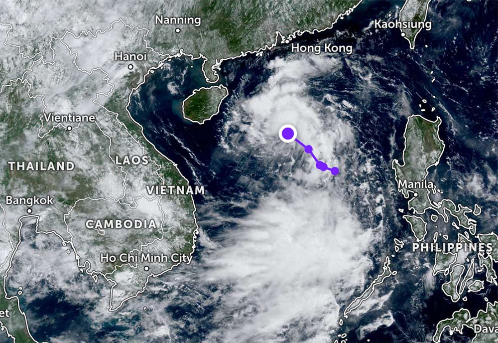
According to the new weather forecast from the National Center for Hydro-Meteorological Forecasting, at 7:00 a.m. on June 25, the center of the tropical depression was at about 17.7 degrees North latitude; 114.6 degrees East longitude, about 360km East Northeast of Hoang Sa archipelago.
The strongest wind near the center of the tropical depression will reach level 6 (39-49km/h), gusting to level 8. The tropical depression is forecast to continue moving northwest at a speed of 15-20km/h.
By 7:00 a.m. on June 26, the tropical depression is forecast to move northwest, at a speed of about 15km/h and is likely to strengthen.
The center of the tropical depression will be at about 19.4 degrees North latitude; 112.6 degrees East longitude, about 180km east of Hainan Island (China). The intensity is forecast to strengthen to level 6-7, gusting to level 9.
Dangerous areas in the East Sea in the next 24 hours (powerful winds from level 6 and above, gusting from level 8 and above) are within the range of 16.5 to 21.0 degrees North latitude and from 111.5 to 115.5 degrees East longitude. Natural disaster risk level due to strong winds at sea: level 3.
It is forecasted that by 7:00 a.m. on June 27, the tropical depression will continue to move northwest, at a speed of about 15km/h and will gradually weaken.
The center of the tropical depression was then at about 21.6 degrees North latitude; 110.4 degrees East longitude, on the mainland southwest of Guangdong province (China). The intensity decreased to level 6, gust level 8.
The danger zone will expand to the North, above latitude 18.0 degrees North, from 109.0 to 113.5 degrees East longitude. Natural disaster risk level: level 3.
In the North East Sea area, including the Hoang Sa archipelago, thunderstorms are forecast to be accompanied by strong winds of level 6-7, gusting to level 9. Strong seas, waves are generally 2.0 to 4.0 meters high.
In addition, on the day and night of June 25, in the North East Sea area (including Hoang Sa archipelago); the Central and South East Sea area (including the Truong Sa archipelago), the sea area from Binh Thuan to Ca Mau, Ca Mau to Kien Giang and the Gulf of Thailand, there will be showers and thunderstorms. During thunderstorms, there is a possibility of tornadoes and strong gusts of wind of level 6-7.
Ships operating in this area need to pay special attention to the high risk of being affected by strong winds, large waves, tornadoes and thunderstorms. Requesting agencies, units, and fishermen to proactively prevent and closely monitor the next sea weather forecasts.
In the coming days, thunderstorms, strong winds and rough seas are forecast due to the influence of the tropical depression. Tourists planning to travel by sea, visit islands or travel by boat in the Gulf of Tonkin; sea tourism destinations in southern China such as Hainan Island, Guangdong, Guangxi... during this time should regularly monitor weather forecasts.
Proactively adjust your schedule and limit activities at sea to ensure safety. Tours operating islands and water sports activities should be temporarily suspended or have appropriate backup plans.


