According to the latest weather forecast from the National Center for Hydro-Meteorological Forecasting, the tropical depression in the East Sea has officially strengthened into storm No. 6.
As of 1:00 p.m. this afternoon, the center of the storm was at panic 17.9 degrees North latitude - 107.0 degrees East longitude, in the Ha Tinh sea area - Hue city, about 65km east of the northern area of Quang Tri.
The strongest wind near the storm center is level 8 (62-74km/h), gusting to level 10. It is forecasted that in the next 3 hours, the storm will move westward, at a speed of about 25km/h.
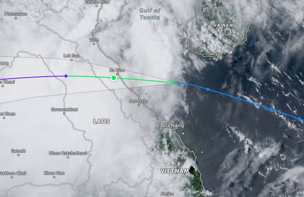
It is forecasted that by 10:00 p.m. today, the storm will move west-northwest at a speed of about 20 km/h, make landfall in Ha Tinh - Bac Quang Tri and weaken into a tropical depression. The center of the storm is located at about 18.1 degrees North latitude - 105.3 degrees East longitude (Vietnam - Laos border). Strong wind level 6, gusting to 8.
At 10:00 on August 31, the tropical depression continued to move west-northwest at a speed of about 20 km/h, into Central Laos and weakened into a low pressure area.
Natural disaster risk level: level 3 for the Thanh Hoa - Hue sea area (including Hon Ngu, Con Co).
Due to the impact of storm No. 6, the area from Thanh Hoa - Hue (hon Ngu, Con Co) will have winds of level 67, near the center of the strong storm, level 8, gusting to level 10. Waves 2.04.0m, near the center of the storm 3.05.0m high, rough seas. The North of the Gulf of Tonkin has strong winds of level 67, gusts of 9, waves 2.04.0m high.
Nghe An - Hue City area, the water rose 0.20.4m. It is very dangerous for boats, cages, aquaculture areas, and coastal works.
On land, the area from Nghe An - Quang Tri has strong winds of level 6, gusting to 8; especially Ha Tinh - Bac Quang Tri has level 67, near the storm center, strong winds of level 8, gusting to 10.
From noon on August 30 to the end of August 31, the area from Thanh Hoa to Hue will have heavy to very heavy rain, generally from 100250mm, locally over 400mm.
In the midlands and Northern Delta, there will be moderate to heavy rain, generally 50120mm, in some places over 250mm.
People and tourists planning to visit these areas should pay attention to weather forecasts. Tuan follows local instructions to avoid storms that cause impacts.


