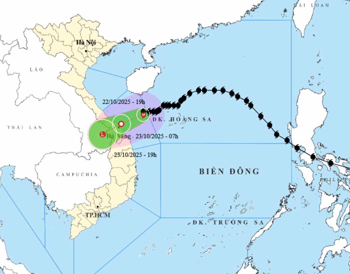
According to the National Center for Hydro-Meteorological Forecasting, at 7:00 a.m. this morning, October 23, storm No. 12 moved in a West-Southwest direction at a speed of about 10 km/h. The center of the storm is located at about 16.3 degrees North latitude - 18.5 degrees East longitude, in the coastal areas of Da Nang - Quang Ngai provinces and gradually weakens.
The strongest wind near the storm center is level 6, gusting to level 9. Natural disaster risk level: level 3 for the western sea area of the North East Sea (including Hoang Sa special zone), the sea area from Quang Tri to Quang Ngai (including Con Co special zone, Cu Lao Cham island and Ly Son special zone); coastal mainland of the provinces from Quang Tri to Da Nang city.
At 7:00 p.m. on October 23, the storm moved in a West-Southwest direction at a speed of about 15km/h and weakened into a low pressure area. The center of the low pressure is located at about 15.6 degrees North latitude -107.0 degrees East longitude, in the area south of Laos. Natural disaster risk level: level 3 for the sea area from Quang Tri to Quang Ngai (including Con Co special zone, Cu Lao Cham island and Ly Son special zone); coastal mainland of the provinces from Quang Tri to Da Nang city.
Due to the influence of the storm, the sea area west of the North East Sea (including Hoang Sa special zone) has strong winds of level 6-7; the area near the storm's eye has strong winds of level 8, gusts of level 10; waves 3.0-5.0m high, rough seas.
The sea area from Quang Tri to Quang Ngai (including Con Co special area, Cu Lao Cham island and Ly Son special area) has strong winds of level 6-7, gusts of level 9, waves 3.0-5.0m high, rough seas.
The circulation of storm No. 12 combined with strong cold air caused from the evening and night of October 22, on the mainland along the coast of the provinces from Quang Tri to Da Nang City, the winds gradually increased to level 5, some places reached level 6, gusting to level 8.
From now until the night of October 24, in the area from Ha Tinh to Quang Ngai, there will be heavy rain and thunderstorms with common rainfall of 100-200mm, locally very heavy rain over 300mm; in the area from South Quang Tri to Da Nang City, there will be heavy to very heavy rain with common rainfall of 200-400mm, locally over 700mm (high intensity rain concentrated from the night of October 22 to the end of October 23).
Warning of the risk of heavy rain (>150mm/3 hours) in coastal communes/wards from South Quang Tri to Da Nang City. Heavy rain in the Central region is likely to last until the end of October 2025. There is a high risk of flash floods and landslides in mountainous areas, flooding in low-lying areas and urban areas.
People and tourists in these areas need to be on guard against the risk of thunderstorms, whirlwinds and strong gusts of wind in the area affected by the storm's circulation, both before and during the storm's landfall. Regularly check flight schedules and follow local instructions to avoid dangerous storms.
Weather forecast for today, October 23 nationwide:
Hanoi
Lowest temperature: 19-21 degrees Celsius.
Highest temperature: 24-26 degrees Celsius.
Cloudy, no rain.Northeast wind level 3.Cold at night and morning.
Northwest
Lowest temperature: 18-21 degrees Celsius, some places below 17 degrees Celsius.
Highest temperature: 25-28 degrees Celsius.
Cloudy, some rain at night; sunny during the day. Light wind. Cold at night and morning, some places are cold.
Northeast
Lowest temperature: 19-21 degrees Celsius, mountainous and midland areas 17-19 degrees Celsius, high mountainous areas below 16 degrees Celsius.
Highest temperature: 24-27 degrees Celsius, some places above 27 degrees Celsius.
Cloudy, with rain in some places. Northeast wind level 3, especially coastal areas level 4, some places level 5. Cold at night and morning, mountainous areas are cold.
Thanh Hoa to Hue
Lowest temperature: 20-23 degrees Celsius.
Highest temperature: 24-27 degrees Celsius.
The North (Thanh Hoa - Nghe An) is cloudy, with rain in some places. The South (from Ha Tinh to Hue City) is cloudy, with moderate rain, heavy rain and thunderstorms, locally very heavy rain; the South of Quang Tri and Hue City have heavy to very heavy rain.
North to northwest wind level 3, coastal areas level 4, some places level2; coastal areas from Quang Tri to Hue City winds gradually increase to level 6, sometimes level 7, gusting to level 8-9. During thunderstorms, there is a possibility of tornadoes, lightning and strong gusts of wind.
South Central Coast
Lowest temperature: 23-26 degrees Celsius.
Highest temperature: North 26-29 degrees Celsius, South 29-32 degrees Celsius.
Cloudy, the North has moderate rain, heavy rain and thunderstorms, some places have very heavy rain; Da Nang City has heavy to very heavy rain. North to northwest wind level 3, from the coastal afternoon of Da Nang City, the wind gradually strengthens to level 6, sometimes level 7, gusting to level 8-9.
The South is cloudy, with scattered showers and thunderstorms; especially tonight and tomorrow evening, there will be scattered showers and thunderstorms, with some places having heavy rain. North to northeast wind level 2-3. During thunderstorms, there is a possibility of tornadoes, lightning and strong gusts of wind.
Central Highlands
Lowest temperature: 19-22 degrees Celsius.
Highest temperature: 27-30 degrees Celsius, some places above 30 degrees Celsius.
Cloudy, with showers and thunderstorms in some places; in the afternoon and evening, there will be scattered showers and thunderstorms, with some places having heavy rain. Light wind. During thunderstorms, there is a possibility of tornadoes, lightning, hail and strong gusts of wind.
Southern region
Lowest temperature: 23-26 degrees Celsius.
Highest temperature: 31-34 degrees Celsius.
Cloudy, with showers and thunderstorms in some places; in the afternoon and evening, there will be scattered showers and thunderstorms, with some places having heavy rain. Light wind. During thunderstorms, there is a possibility of tornadoes, lightning, hail and strong gusts of wind.
Ho Chi Minh City
Lowest temperature: 24-26 degrees Celsius.
Highest temperature: 32-34 degrees Celsius.
Cloudy, with showers and thunderstorms in some places; in the afternoon and evening, there will be scattered showers and thunderstorms, with some places having heavy rain. Light wind. During thunderstorms, there is a possibility of tornadoes, lightning, hail and strong gusts of wind.