According to the latest weather forecast from the National Center for Hydro-Meteorological Forecasting, tomorrow the North, Thanh Hoa and Nghe An will have rain in some places. Cold at night and morning, some mountainous areas are cold.
The area from Ha Tinh to Quang Ngai will have heavy rain and thunderstorms, especially the area from South Quang Tri to Da Nang City will have heavy to very heavy rain due to the impact of storm No. 12 Fengshen.
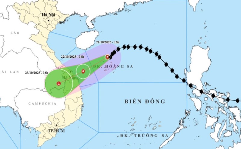
At 7:00 p.m. on October 22, the center of storm No. 12 Fengshen was at about 16.8 degrees North latitude; 109.7 degrees East longitude, about 170km East Northeast of Da Nang City.
The strongest wind near the storm center is level 9 (75-88km/h), gusting to level 11.
It is forecasted that by dawn on October 23, storm No. 12 will gradually weaken to level 8, gusting to level 10 when about 100 km from Da Nang.
On the same afternoon, storm No. 12 officially made landfall in Da Nang, continuing to gradually weaken into a low pressure area in the western area of the city.
Meanwhile, a tropical depression in the sea east of Taiwan (China) is forecast to enter the eastern sea of the North East Sea on the afternoon of October 23.
From the next 48 to 72 hours, the tropical depression will move mainly in the West Southwest direction, traveling 15-20km per hour and gradually weakening into a low pressure area.
The coastal areas of the provinces from Quang Tri to Da Nang City will have storm surge of 0.4-0.8m high.
Due to the influence of storm circulation and cold air combined with East wind disturbances and terrain effects, from the night of October 22 to October 24, in the area from Ha Tinh to Quang Ngai, there will be heavy rain and thunderstorms with common rainfall of 100-250mm, locally very heavy rain over 350mm.
In particular, the area from South Quang Tri to Da Nang City will have heavy to very heavy rain with common rainfall of 400-600mm, locally over 800mm (heavy rain will be concentrated from the night of October 22 to the end of October 23).
Heavy rain in the Central region is likely to last until the end of October 2025.
People and tourists in the Quang Tri area to Da Nang should be on guard against high risk of flash floods and landslides in mountainous areas, flooding in low-lying areas and urban areas.
Weather forecast for tomorrow, October 23 nationwide:
Hanoi
Lowest temperature: 19-21 degrees Celsius.
Highest temperature: 24-26 degrees Celsius.
Cloudy, no rain.Northeast wind level 3.Cold at night and morning.
Northwest
Lowest temperature: 18-21 degrees Celsius, some places below 17 degrees Celsius.
Highest temperature: 25-28 degrees Celsius.
Cloudy, some rain at night; sunny during the day. Light wind. Cold at night and morning, some places are cold.
Northeast
Lowest temperature: 19-21 degrees Celsius, mountainous and midland areas 17-19 degrees Celsius, high mountainous areas below 16 degrees Celsius.
Highest temperature: 24-27 degrees Celsius, some places above 27 degrees Celsius.
Cloudy, with rain in some places. Northeast wind level 3, especially coastal areas level 4, some places level 5. Cold at night and morning, mountainous areas are cold.
Thanh Hoa to Hue
Lowest temperature: 20-23 degrees Celsius.
Highest temperature: 24-27 degrees Celsius.
The North (Thanh Hoa - Nghe An) is cloudy, with rain in some places. The South (from Ha Tinh to Hue City) is cloudy, with moderate rain, heavy rain and thunderstorms, locally very heavy rain; the South of Quang Tri and Hue City have heavy to very heavy rain.
North to northwest wind level 3, coastal areas level 4, some places level2; coastal areas from Quang Tri to Hue City winds gradually increase to level 6, sometimes level 7, gusting to level 8-9. During thunderstorms, there is a possibility of tornadoes, lightning and strong gusts of wind.
South Central Coast
Lowest temperature: 23-26 degrees Celsius.
Highest temperature: North 26-29 degrees Celsius, South 29-32 degrees Celsius.
Cloudy, the North has moderate rain, heavy rain and thunderstorms, some places have very heavy rain; Da Nang City has heavy to very heavy rain. North to northwest wind level 3, from the coastal afternoon of Da Nang City, the wind gradually strengthens to level 6, sometimes level 7, gusting to level 8-9.
The South is cloudy, with scattered showers and thunderstorms; especially tonight and tomorrow evening, there will be scattered showers and thunderstorms, with some places having heavy rain. North to northeast wind level 2-3. During thunderstorms, there is a possibility of tornadoes, lightning and strong gusts of wind.
Central Highlands
Lowest temperature: 19-22 degrees Celsius.
Highest temperature: 27-30 degrees Celsius, some places above 30 degrees Celsius.
Cloudy, with showers and thunderstorms in some places; in the afternoon and evening, there will be scattered showers and thunderstorms, with some places having heavy rain. Light wind. During thunderstorms, there is a possibility of tornadoes, lightning, hail and strong gusts of wind.
Southern region
Lowest temperature: 23-26 degrees Celsius.
Highest temperature: 31-34 degrees Celsius.
Cloudy, with showers and thunderstorms in some places; in the afternoon and evening, there will be scattered showers and thunderstorms, with some places having heavy rain. Light wind. During thunderstorms, there is a possibility of tornadoes, lightning, hail and strong gusts of wind.
Ho Chi Minh City
Lowest temperature: 24-26 degrees Celsius.
Highest temperature: 32-34 degrees Celsius.
Cloudy, with showers and thunderstorms in some places; in the afternoon and evening, there will be scattered showers and thunderstorms, with some places having heavy rain. Light wind. During thunderstorms, there is a possibility of tornadoes, lightning, hail and strong gusts of wind.